Article
Pointe-Claire
Pointe-Claire was first set up as a village municipality under the name of Saint-Joachim-de-la-Pointe-Claire in 1854. Its name was shortened when it was incorporated.
Signing up enhances your TCE experience with the ability to save items to your personal reading list, and access the interactive map.
Create AccountArticle
Pointe-Claire was first set up as a village municipality under the name of Saint-Joachim-de-la-Pointe-Claire in 1854. Its name was shortened when it was incorporated.
"https://development.thecanadianencyclopedia.ca/images/tce_placeholder.jpg?v=e9dca980c9bdb3aa11e832e7ea94f5d9" // resources/views/front/categories/view.blade.phphttps://development.thecanadianencyclopedia.ca/images/tce_placeholder.jpg?v=e9dca980c9bdb3aa11e832e7ea94f5d9

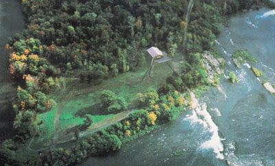
Article
Pointe-du-Buisson is a small point of land (21 ha) extending into the waters of Lake St Louis (a widening of the St-Lawrence River) at the convergence of the Ottawa River.
"https://d2ttikhf7xbzbs.cloudfront.net/media/media/b8bf0f8e-3c7a-4b11-9fa4-efe4e14a1650.jpg" // resources/views/front/categories/view.blade.phphttps://d2ttikhf7xbzbs.cloudfront.net/media/media/b8bf0f8e-3c7a-4b11-9fa4-efe4e14a1650.jpg
Article
The province of British Columbia has a majority New Democratic Party government, formed on 24 October 2020. The premier of the province is David Eby and the lieutenant-governor is Janet Austin. Its first premier, John Foster McCreight, was elected in 1871, after the province joined Confederation. Prior to Confederation, BC was a British colony, administered by a governor and a legislative assembly.
"https://d2ttikhf7xbzbs.cloudfront.net/media/new_article_images/PoliticsInBC/SirRichardMcBride_CityofVancouverArchives_LGN952.jpg" // resources/views/front/categories/view.blade.phphttps://d2ttikhf7xbzbs.cloudfront.net/media/new_article_images/PoliticsInBC/SirRichardMcBride_CityofVancouverArchives_LGN952.jpg

Article
The province of Newfoundland and Labrador has a minority Liberal government, elected on 16 May 2019. The premier of the province is Andrew Furey and the Lieutenant Governor is Judy May Foote. Its first premier, Joey Smallwood, was elected in 1949, after the province joined Confederation. Prior to Confederation, Newfoundland was first a British colony, then beginning in 1907, a dominion of the British Empire. It has been governed in various ways throughout its history, beginning with naval law in the 1600s.
"https://d2ttikhf7xbzbs.cloudfront.net/media/media/f20cb6e1-b1bb-4a81-9c3b-acbd65f7feb8.jpg" // resources/views/front/categories/view.blade.phphttps://d2ttikhf7xbzbs.cloudfront.net/media/media/f20cb6e1-b1bb-4a81-9c3b-acbd65f7feb8.jpg

Article
Ponoka, Alta, incorporated as a town in 1904, population 6773 (2011c), 6576 (2006c). The Town of Ponoka is located approximately 100 km south of Edmonton in rolling, rich parkbelt land. The Methodists established a mission to the Stoney at the nearby Samson Reserve in the late 1870s.
"https://development.thecanadianencyclopedia.ca/images/tce_placeholder.jpg?v=e9dca980c9bdb3aa11e832e7ea94f5d9" // resources/views/front/categories/view.blade.phphttps://development.thecanadianencyclopedia.ca/images/tce_placeholder.jpg?v=e9dca980c9bdb3aa11e832e7ea94f5d9
Article
Port Alberni, BC, incorporated as a city in 1967, population 17,678 (2016 c), 17,743 (2011 c). The present-day City of Port Alberni is the result of the 1967 amalgamation of two cities, Port Alberni (incorporated in 1912) and Alberni (incorporated in 1913). Port Alberni is located on central Vancouver Island, 195 km north of Victoria, at the head of Alberni Inlet, a deep fjord-like inlet that almost divides the island in two. The inlet was named after Don Pedro de Alberni, the Spanish officer in command of the Nootka garrison in 1791 during the Spanish occupation. In 1964, a tsunami caused by the Good Friday earthquake in Alaska moved up the inlet and hit the twin cities. About 375 houses were damaged, 55 of which were washed away, but there were no casualties.
"https://d2ttikhf7xbzbs.cloudfront.net/media/media/a4a66b07-c602-42f7-a156-77ed5d1334ff.jpg" // resources/views/front/categories/view.blade.phphttps://d2ttikhf7xbzbs.cloudfront.net/media/media/a4a66b07-c602-42f7-a156-77ed5d1334ff.jpg

Article
Port au Choix, NL, incorporated as a town in 1966, population 839 (2011c), 893 (2006c). The Town of Port au Choix is located on the west side of the Northern Peninsula.
"https://d2ttikhf7xbzbs.cloudfront.net/media/media/e18c8b0a-0307-4e37-b091-5665412f4aa5.jpg" // resources/views/front/categories/view.blade.phphttps://d2ttikhf7xbzbs.cloudfront.net/media/media/e18c8b0a-0307-4e37-b091-5665412f4aa5.jpg

Article
Port-au-Port peninsula is a roughly triangular peninsula with 130 km of rocky coastline but no harbours. The peninsula is joined to southwestern Newfoundland via a strip of land west of Stephenville. Port-au-Port is home to Newfoundland’s oldest francophone communities (see Francophones of Newfoundland and Labrador).
"https://development.thecanadianencyclopedia.ca/images/tce_placeholder.jpg?v=e9dca980c9bdb3aa11e832e7ea94f5d9" // resources/views/front/categories/view.blade.phphttps://development.thecanadianencyclopedia.ca/images/tce_placeholder.jpg?v=e9dca980c9bdb3aa11e832e7ea94f5d9
Article
Port Colborne, Ontario, incorporated as a city in 1966, population 18,306 (2016 census), 18,424 (2011 census). The city of Port Colborne is located on Lake Erie and serves as the south port of entry to the Welland Canal. It was named for Sir John Colborne, a lieutenant-governor of Upper Canada.
"https://development.thecanadianencyclopedia.ca/images/tce_placeholder.jpg?v=e9dca980c9bdb3aa11e832e7ea94f5d9" // resources/views/front/categories/view.blade.phphttps://development.thecanadianencyclopedia.ca/images/tce_placeholder.jpg?v=e9dca980c9bdb3aa11e832e7ea94f5d9
Article
Port Coquitlam, British Columbia, incorporated as a city in 1913, population 61,498 (2021 census), 58,612 (2016 census). The City of Port Coquitlam is located on the Pitt and Fraser rivers, 27 km east of Vancouver. It is bounded on the north and west by the City of Coquitlam. It is a member of the Metro Vancouver Regional District and part of the Tri-Cities with Coquitlam and Port Moody.
"https://development.thecanadianencyclopedia.ca/images/tce_placeholder.jpg?v=e9dca980c9bdb3aa11e832e7ea94f5d9" // resources/views/front/categories/view.blade.phphttps://development.thecanadianencyclopedia.ca/images/tce_placeholder.jpg?v=e9dca980c9bdb3aa11e832e7ea94f5d9
Article
Port Edward, BC, incorporated as a district municipality in 1991, population 544 (2011c), 577 (2006c). The District of Port Edward is located near PRINCE RUPERT on British Columbia's northern mainland coast, on Inverness Passage near the mouth of the SKEENA RIVER.
"https://development.thecanadianencyclopedia.ca/images/tce_placeholder.jpg?v=e9dca980c9bdb3aa11e832e7ea94f5d9" // resources/views/front/categories/view.blade.phphttps://development.thecanadianencyclopedia.ca/images/tce_placeholder.jpg?v=e9dca980c9bdb3aa11e832e7ea94f5d9
Article
Port Hardy, BC, incorporated as a district municipality in 1966, population 4008 (2011c), 3822 (2006c). The District of Port Hardy is located on the northeast coast of VANCOUVER ISLAND, 391 km by road north of NANAIMO.
"https://development.thecanadianencyclopedia.ca/images/tce_placeholder.jpg?v=e9dca980c9bdb3aa11e832e7ea94f5d9" // resources/views/front/categories/view.blade.phphttps://development.thecanadianencyclopedia.ca/images/tce_placeholder.jpg?v=e9dca980c9bdb3aa11e832e7ea94f5d9
Article
Some farming and a local forest industry supported the livelihood of the dominant Scottish population. As an early 19th-century ferry terminus and later a railway centre, the town suffered the loss of these activities from the building of the Canso Causeway in the mid-1950s at nearby Port Hastings.
"https://development.thecanadianencyclopedia.ca/images/tce_placeholder.jpg?v=e9dca980c9bdb3aa11e832e7ea94f5d9" // resources/views/front/categories/view.blade.phphttps://development.thecanadianencyclopedia.ca/images/tce_placeholder.jpg?v=e9dca980c9bdb3aa11e832e7ea94f5d9
Article
Long a manufacturing and regional commercial centre, Port Hope's main street is one of the best preserved from late 19th-century Ontario. It is now a centre for uranium refining and the manufacture of machinery, tools, plastics and rubber.
"https://development.thecanadianencyclopedia.ca/images/tce_placeholder.jpg?v=e9dca980c9bdb3aa11e832e7ea94f5d9" // resources/views/front/categories/view.blade.phphttps://development.thecanadianencyclopedia.ca/images/tce_placeholder.jpg?v=e9dca980c9bdb3aa11e832e7ea94f5d9
Article
Port McNeill, BC, incorporated as a town in 1984, population 2505 (2011c), 2623 (2006c). The Town of Port McNeill is located on the northeast coast of VANCOUVER ISLAND on Broughton Strait, 200 km northwest of CAMPBELL RIVER.
"https://d2ttikhf7xbzbs.cloudfront.net/media/media/af04bfbb-be18-40ef-869d-accbd98f0e3a.jpg" // resources/views/front/categories/view.blade.phphttps://d2ttikhf7xbzbs.cloudfront.net/media/media/af04bfbb-be18-40ef-869d-accbd98f0e3a.jpg
