Browse "Indigenous Reserves & Settlements"
-
List
30 Indigenous Place Names and their Meanings
To celebrate its 30th anniversary, The Canadian Encyclopedia created 30 lists of 30 things that have helped define our identity, from famous people and historic events, to iconic foods and influential artists.
"https://d2ttikhf7xbzbs.cloudfront.net/media/media/a7c708ef-3e7b-4890-a1ad-f637397985a6.jpg" // resources/views/front/categories/view.blade.php
https://d2ttikhf7xbzbs.cloudfront.net/media/media/a7c708ef-3e7b-4890-a1ad-f637397985a6.jpg
-
Article
Reserves in Canada
A reserve is land set aside by the Canadian government for use by First Nations. Reserves are managed under the Indian Act. Reserve lands represent a small fraction of the traditional territories First Nations had before European colonization. While reserves are places where members of a First Nation live, some reserves are used for hunting and other activities. Many First Nations hold more than one parcel of reserve land, and some reserves are shared by more than one First Nation. There are reserves in every province in Canada, but few have been established in the territories. Most reserves are rural, though some First Nations have created urban reserves, which are reserves within or neighboring a city. This is the full-length entry about Reserves in Canada. If you are interested in reading a plain-language summary, please see Reserves in Canada (Plain Language Summary).
"https://d2ttikhf7xbzbs.cloudfront.net/media/new_article_images/ReservesON/GardenRiver.jpg" // resources/views/front/categories/view.blade.php
https://d2ttikhf7xbzbs.cloudfront.net/media/new_article_images/ReservesON/GardenRiver.jpg
-
Article
Batoche
The Métis community of Batoche is a national historic site in central Saskatchewan. It was the scene, in 1885, of the last significant battle of the North-West Resistance, where Métis and Indigenous resistors led by Louis Riel and Gabriel Dumont were defeated by federal government militia, effectively bringing an end to the uprising.
"https://d2ttikhf7xbzbs.cloudfront.net/media/media/44b2bd9e-c62a-4a72-b6a8-029e1173ce70.jpg" // resources/views/front/categories/view.blade.php
https://d2ttikhf7xbzbs.cloudfront.net/media/media/44b2bd9e-c62a-4a72-b6a8-029e1173ce70.jpg
-
Article
Carcross
Carcross, Yukon, settlement, population 301 (2016 census), 289 (2011 census). Carcross is a major Tagish and Tlingit community located at the north end of Bennett Lake, 74 km south of Whitehorse.
"https://development.thecanadianencyclopedia.ca/images/tce_placeholder.jpg?v=e9dca980c9bdb3aa11e832e7ea94f5d9" // resources/views/front/categories/view.blade.php
https://development.thecanadianencyclopedia.ca/images/tce_placeholder.jpg?v=e9dca980c9bdb3aa11e832e7ea94f5d9
-
Article
Cassiar District
The Cassiar District lies in British Columbia's northwest corner; it historically encompasses the Stikine and Dease River watersheds and that of the upper Taku, NASS and Kechika.
"https://development.thecanadianencyclopedia.ca/images/tce_placeholder.jpg?v=e9dca980c9bdb3aa11e832e7ea94f5d9" // resources/views/front/categories/view.blade.php
https://development.thecanadianencyclopedia.ca/images/tce_placeholder.jpg?v=e9dca980c9bdb3aa11e832e7ea94f5d9
-
Article
Cumberland House
The construction of Cumberland House in 1774 marked a change in HBC policy, which had hitherto expected Indigenous people to bring their furs to the bay posts to trade.
"https://d2ttikhf7xbzbs.cloudfront.net/media/media/ae69d3f2-aebe-4a53-b1a8-ddfebac57e3f.jpg" // resources/views/front/categories/view.blade.php
https://d2ttikhf7xbzbs.cloudfront.net/media/media/ae69d3f2-aebe-4a53-b1a8-ddfebac57e3f.jpg
-
Article
Gjoa Haven
Gjoa Haven, Nunavut, incorporated as a hamlet in 1981, population 1,324 (2016 census), 1,279 (2011 census). The hamlet of Gjoa Haven is located on the southeast coast of King William Island, off the mainland Arctic coast, and just over 1,320 km northwest of Iqaluit. Channels and bays in the area are icebound for most of the year. It derived its name from Roald Amundsen, the first person to navigate the Northwest Passage. He wintered there and called the site after his ship, the Gjoa.
"https://d2ttikhf7xbzbs.cloudfront.net/media/media/5ee39267-11b5-446e-b051-119d53468b58.jpg" // resources/views/front/categories/view.blade.php
https://d2ttikhf7xbzbs.cloudfront.net/media/media/5ee39267-11b5-446e-b051-119d53468b58.jpg
-
Article
Grise Fiord
Grise Fiord, Nunavut, incorporated as a hamlet in 1987, population 130 (2011c), 141 (2006c). The Hamlet of Grise Fiord is located on the south coast of ELLESMERE ISLAND.
"https://d2ttikhf7xbzbs.cloudfront.net/media/media/81bcc22e-e2e4-4910-bb40-41c34dc9ce59.jpg" // resources/views/front/categories/view.blade.php
https://d2ttikhf7xbzbs.cloudfront.net/media/media/81bcc22e-e2e4-4910-bb40-41c34dc9ce59.jpg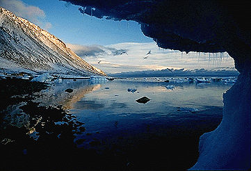
-
Article
Gwaii Haanas
At 1,470 km2, Gwaii Haanas National Park Reserve, National Marine Conservation Area Reserve, and Haida Heritage Site (also known as Gwaii Haanas) encompasses 15 per cent of Haida Gwaii.
"https://d2ttikhf7xbzbs.cloudfront.net/media/media/77c96547-25d5-4295-a540-5a07340acb6c.jpg" // resources/views/front/categories/view.blade.php
https://d2ttikhf7xbzbs.cloudfront.net/media/media/77c96547-25d5-4295-a540-5a07340acb6c.jpg
-
Article
Keno Hill
Keno Hill (or Keno City), YT, Settlement, pop 15 (2006c), 20 (2001c). Keno Hill is located 122 km northwest of the Klondike Highway, 466 km by road north from Whitehorse. In 1919 Louis Beauvette staked the Roulette silver-lead claim on top of Keno Hill in the MAYO district.
"https://development.thecanadianencyclopedia.ca/images/tce_placeholder.jpg?v=e9dca980c9bdb3aa11e832e7ea94f5d9" // resources/views/front/categories/view.blade.php
https://development.thecanadianencyclopedia.ca/images/tce_placeholder.jpg?v=e9dca980c9bdb3aa11e832e7ea94f5d9
-
Article
Listuguj
Listuguj, Quebec, is the common name for both a reserve and a Mi'kmaq First Nation. Listuguj is located on the Gaspé Peninsula at the mouth of Restigouche River. A bridge links it to Campbellton, New Brunswick. As of 2014, the Listuguj First Nation has 4,058 members, with 2,108 members living on the Listuguj reserve. The community was also previously known as Restigouche.
"https://development.thecanadianencyclopedia.ca/images/tce_placeholder.jpg?v=e9dca980c9bdb3aa11e832e7ea94f5d9" // resources/views/front/categories/view.blade.php
https://development.thecanadianencyclopedia.ca/images/tce_placeholder.jpg?v=e9dca980c9bdb3aa11e832e7ea94f5d9
-
Article
Métis Road Allowance Communities
Road allowance communities were home to Métis families throughout the late 1800s until the mid- to late 1900s. Métis peoples used the road allowances as new home communities after experiencing relocations, migrations and dispossession from their homelands. After resistance and violence in a period during and after the Riel Resistance of 1869–1870 and the North–West Resistance in 1885, Métis were marginalized and labelled as rebellious or troublesome by the government of Canada and the provinces.
"https://d2ttikhf7xbzbs.cloudfront.net/media/media/RoosterTownFamily.jpg" // resources/views/front/categories/view.blade.php
https://d2ttikhf7xbzbs.cloudfront.net/media/media/RoosterTownFamily.jpg
-
Article
History of Métis Settlements in Canada
Métis communities are found in many provinces and territories in Canada; however, the only legislated Métis land base is in Alberta. Eight Métis settlements are located across the northern and central-eastern part of the province: Paddle Prairie, Peavine, Gift Lake, East Prairie, Buffalo Lake, Kikino, Elizabeth and Fishing Lake. As of 2021, the settlements cover 1.25 million acres of land and are home to approximately 4,238 people. That year, 3,540 people reported that they were registered members of Métis Settlements in Alberta. The Métis Settlements are self-governing and provide for the protection of Métis culture and identity.
"https://d2ttikhf7xbzbs.cloudfront.net/MetisSettlementsFlag/Metis_Settlements_Flag.gif" // resources/views/front/categories/view.blade.php
https://d2ttikhf7xbzbs.cloudfront.net/MetisSettlementsFlag/Metis_Settlements_Flag.gif
-
Article
Nahanni Butte
Nahanni Butte, NWT, Settlement, population 102 (2011c), 115 (2006c). The settlement of Nahanni Butte is located on the north side of the SOUTH NAHANNI RIVER near its junction with the LIARD RIVER, about 125 km north of the Northwest Territories and British Columbia border.
"https://development.thecanadianencyclopedia.ca/images/tce_placeholder.jpg?v=e9dca980c9bdb3aa11e832e7ea94f5d9" // resources/views/front/categories/view.blade.php
https://development.thecanadianencyclopedia.ca/images/tce_placeholder.jpg?v=e9dca980c9bdb3aa11e832e7ea94f5d9
-
Article
Nanisivik
Nanisivik, Nunavut, is a settlement located on the south shore of Strathcona Sound on the Borden Peninsula of Baffin Island, 280 km northwest of Iqaluit.
"https://development.thecanadianencyclopedia.ca/images/tce_placeholder.jpg?v=e9dca980c9bdb3aa11e832e7ea94f5d9" // resources/views/front/categories/view.blade.php
https://development.thecanadianencyclopedia.ca/images/tce_placeholder.jpg?v=e9dca980c9bdb3aa11e832e7ea94f5d9