Browse "Towns"
-
Article
Creighton
The town of Creighton dates from the 1930s when the Department of Natural Resources constructed a road from Flin Flon to Amisk Lake. People began to settle along the road, and after World War II a town site was surveyed. The lots were largely taken up by young men returning from the armed services.
"https://d2ttikhf7xbzbs.cloudfront.net/media/media/d327e8c0-7182-4be6-8d02-fa173c58bd79.jpg" // resources/views/front/categories/view.blade.php
https://d2ttikhf7xbzbs.cloudfront.net/media/media/d327e8c0-7182-4be6-8d02-fa173c58bd79.jpg
-
Article
Creston
Creston, BC, incorporated as a town in 1924, population 5306 (2011c), 4826 (2006c). The Town of Creston is located in the west Kootenay region of southeastern British Columbia.
"https://development.thecanadianencyclopedia.ca/images/tce_placeholder.jpg?v=e9dca980c9bdb3aa11e832e7ea94f5d9" // resources/views/front/categories/view.blade.php
https://development.thecanadianencyclopedia.ca/images/tce_placeholder.jpg?v=e9dca980c9bdb3aa11e832e7ea94f5d9
-
Article
Cupids
Cupids, Newfoundland and Labrador, incorporated as a town in 1965, population 743 (2016 census), 761 (2011 census). The town of Cupids is located in southwest Conception Bay on the Avalon Peninsula, about 80 km west of St. John's. Originally known as Cupers Cove (1610), other early variants of the name include Cuperts Cove and Kibby's Cove. However, the name Cupids Cove appears quite early: Sir William Alexander referred to it by this name in his An Encouragement to Colonies (1624). No one knows the origin of the name, but it may be an anglicized version of a Spanish or Basque name.
"https://d2ttikhf7xbzbs.cloudfront.net/media/media/4cdbbbd0-441a-4bc7-b1bb-d46b1b94b893.jpg" // resources/views/front/categories/view.blade.php
https://d2ttikhf7xbzbs.cloudfront.net/media/media/4cdbbbd0-441a-4bc7-b1bb-d46b1b94b893.jpg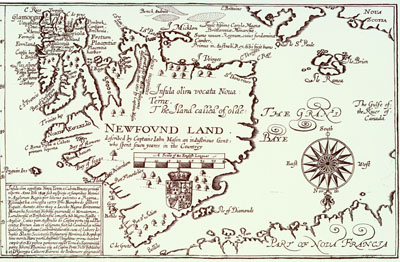
-
Article
Dalhousie
Dalhousie, NB, incorporated as a town in 1905, population 3512 (2011c), 3676 (2006c). The Town of Dalhousie, the shire town of Restigouche County (since 1837), is located on New Brunswick's north shore at the mouth of the Restigouche River.
"https://d2ttikhf7xbzbs.cloudfront.net/media/media/0eeeb273-5c1d-4e2c-9fa2-9ea5b597137e.jpg" // resources/views/front/categories/view.blade.php
https://d2ttikhf7xbzbs.cloudfront.net/media/media/0eeeb273-5c1d-4e2c-9fa2-9ea5b597137e.jpg
-
Article
Dalmeny
Dalmeny, Sask, incorporated as a town in 1983, population 1702 (2011c), 1560 (2006c). The Town of Dalmeny is located 30 km northwest of SASKATOON. It is apparently named after Dalmeny, Scotland.
"https://development.thecanadianencyclopedia.ca/images/tce_placeholder.jpg?v=e9dca980c9bdb3aa11e832e7ea94f5d9" // resources/views/front/categories/view.blade.php
https://development.thecanadianencyclopedia.ca/images/tce_placeholder.jpg?v=e9dca980c9bdb3aa11e832e7ea94f5d9
-
Article
Dawson
Dawson (also Dawson City), Yukon, incorporated as a town in 1904, population 1,577 (2021 census), 1,375 (2016 census). The Town of Dawson is located on the east bank of the Yukon River at the mouth of the Klondike River, 530 km north of Whitehorse.
"https://d2ttikhf7xbzbs.cloudfront.net/media/media/9c017727-fcf3-484b-9dbb-02f507e8486e.jpg" // resources/views/front/categories/view.blade.php
https://d2ttikhf7xbzbs.cloudfront.net/media/media/9c017727-fcf3-484b-9dbb-02f507e8486e.jpg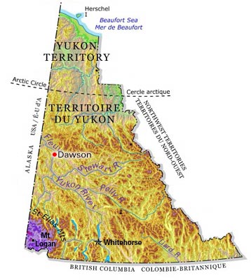
-
Article
Deep River
Deep River, Ont, incorporated as a town in 1959, population 4193 (2011c), 4216 (2006c). The Town of Deep River is located in eastern Ontario, 208 km northwest of Ottawa.
"https://development.thecanadianencyclopedia.ca/images/tce_placeholder.jpg?v=e9dca980c9bdb3aa11e832e7ea94f5d9" // resources/views/front/categories/view.blade.php
https://development.thecanadianencyclopedia.ca/images/tce_placeholder.jpg?v=e9dca980c9bdb3aa11e832e7ea94f5d9
-
Article
Delson
Delson was built up around a junction of the Delaware and Hudson and GRAND TRUNK railway lines. Originally known as Delson Junction, its name is the joining of the first syllable of Delaware to the last syllable of Hudson.
"https://d2ttikhf7xbzbs.cloudfront.net/media/media/da531432-97bc-4fae-93a5-73c5258cab76.jpg" // resources/views/front/categories/view.blade.php
https://d2ttikhf7xbzbs.cloudfront.net/media/media/da531432-97bc-4fae-93a5-73c5258cab76.jpg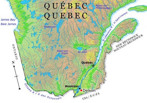
-
Article
Didsbury
Didsbury, Alta, incorporated as a town in 1906, population 4957 (2011c), 4305 (2006c). The Town of Didsbury is located about 75 km north of Calgary and is named after the town of Didsbury near Manchester in England.
"https://development.thecanadianencyclopedia.ca/images/tce_placeholder.jpg?v=e9dca980c9bdb3aa11e832e7ea94f5d9" // resources/views/front/categories/view.blade.php
https://development.thecanadianencyclopedia.ca/images/tce_placeholder.jpg?v=e9dca980c9bdb3aa11e832e7ea94f5d9
-
Article
Digby
Digby, NS, incorporated as a town in 1890, population 2152 (2011c), 2092 (2006c). The Town of Digby is located on the west side of the Annapolis Basin in western Nova Scotia.
"https://development.thecanadianencyclopedia.ca/images/tce_placeholder.jpg?v=e9dca980c9bdb3aa11e832e7ea94f5d9" // resources/views/front/categories/view.blade.php
https://development.thecanadianencyclopedia.ca/images/tce_placeholder.jpg?v=e9dca980c9bdb3aa11e832e7ea94f5d9
-
Article
Donnacona (Qué)
History Donnacona had its beginning in 1700 with the building of a paper mill at a site along the river called Fond Jacques-Cartier. A second mill was built in 1815 and a third mill, Donnacona Paper, was built in 1912.
"https://d2ttikhf7xbzbs.cloudfront.net/media/media/25bfb5e0-54ea-4275-922f-a940e33fd2de.jpg" // resources/views/front/categories/view.blade.php
https://d2ttikhf7xbzbs.cloudfront.net/media/media/25bfb5e0-54ea-4275-922f-a940e33fd2de.jpg
-
Article
Drumheller
Drumheller, Alberta, incorporated as a town in 1998, population 7,909 (2021 census), 7,982 (2016 census). The town of Drumheller is located on the Red Deer River in southern Alberta, 138 km northeast of Calgary. The Red Deer River valley is internationally known its abundance of fossils, particularly of dinosaurs.
"https://development.thecanadianencyclopedia.ca/images/tce_placeholder.jpg?v=e9dca980c9bdb3aa11e832e7ea94f5d9" // resources/views/front/categories/view.blade.php
https://development.thecanadianencyclopedia.ca/images/tce_placeholder.jpg?v=e9dca980c9bdb3aa11e832e7ea94f5d9
-
Article
East Gwillimbury
East Gwillimbury, Ontario, incorporated as a town in 1971, population 34,637 (2021 census), 23,991 (2016 census). Located in York Region, East Gwillimbury’s northern border is less than a kilometre from Lake Simcoe. Historic communities within East Gwillimbury include Sharon, Holland Landing, Queensville and Mount Albert. As of 2021, the town was Canada’s fastest growing municipality of over 5,000 people, with a population increase of over 44 per cent between 2016 and 2021. Throughout history, the East Gwillimbury area has been home to different Indigenous groups, namely the Wendat (Huron), Tionontati (Petun), Haudenosaunee and Anishinaabeg, including the Chippewas of Georgina Island First Nation. The land is part of the Williams Treaties (1923).
"https://d2ttikhf7xbzbs.cloudfront.net/EastGwillimbury/SharonTemple.jpg" // resources/views/front/categories/view.blade.php
https://d2ttikhf7xbzbs.cloudfront.net/EastGwillimbury/SharonTemple.jpg
-
Article
Emerson
Emerson, Manitoba, incorporated as a town in 1879, population 671 (2011c), 689 (2006c). The Town of Emerson is Manitoba's main port of entry on the international boundary.
"https://development.thecanadianencyclopedia.ca/images/tce_placeholder.jpg?v=e9dca980c9bdb3aa11e832e7ea94f5d9" // resources/views/front/categories/view.blade.php
https://development.thecanadianencyclopedia.ca/images/tce_placeholder.jpg?v=e9dca980c9bdb3aa11e832e7ea94f5d9
-
Article
Erickson
Swedish and Norwegian immigrants were among the first settlers in the region. They took up homesteads in the Otter Lake and Rolling River area on a reserve called Scandinavia or New Sweden, established in 1885 as part of a campaign to attract Scandinavian immigrants to Canada.
"https://development.thecanadianencyclopedia.ca/images/tce_placeholder.jpg?v=e9dca980c9bdb3aa11e832e7ea94f5d9" // resources/views/front/categories/view.blade.php
https://development.thecanadianencyclopedia.ca/images/tce_placeholder.jpg?v=e9dca980c9bdb3aa11e832e7ea94f5d9