Browse "Cities & Populated Places"
-
Article
British Columbia and Confederation
The colony of British Columbia was founded in 1858 in response to the Fraser River Gold Rush. (See also The Fraser River Gold Rush and the Founding of British Columbia.) The colony established representative government in 1864 and merged with the colony of Vancouver Island in 1866. In May 1868, Amor De Cosmos formed the Confederation League to bring responsible government to BC and to join Confederation. In September 1868, the Confederation League passed 37 resolutions outlining the terms for a union with the Dominion of Canada. The terms were passed by both the BC assembly and the federal Parliament in 1871. The colony joined Canada as the country’s sixth province on 20 July 1871. The threat of American annexation, embodied by the Alaska purchase of 1867, and the promise of a railway linking BC to the rest of Canada, were decisive factors.
"https://d2ttikhf7xbzbs.cloudfront.net/media/media/1f3712f0-f1ac-4fba-a093-ff4c7cfec856.jpg" // resources/views/front/categories/view.blade.php
https://d2ttikhf7xbzbs.cloudfront.net/media/media/1f3712f0-f1ac-4fba-a093-ff4c7cfec856.jpg
-
Article
British North America
British North America refers to the British colonies and territories in North America after the US became independent in 1783 (see also American Revolution) and until Confederation in 1867. The British North America Act (BNA Act), which came into effect on 1 July 1867, united three of the five British North American colonies. The Act (renamed the Constitution Act, 1867, in 1982) is the foundational document of Canada’s Constitution.
"https://d2ttikhf7xbzbs.cloudfront.net/media/media/38e5f8ee-b0d4-46c9-99d7-11bdda3004ce.jpg" // resources/views/front/categories/view.blade.php
https://d2ttikhf7xbzbs.cloudfront.net/media/media/38e5f8ee-b0d4-46c9-99d7-11bdda3004ce.jpg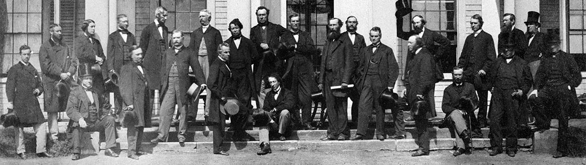
-
Article
Brockville
Brockville, Ont, incorporated as a city in 1962, population 21 870 (2011c), 21 957 (2006c). The City of Brockville is located on the St Lawrence River, 80 km east of Kingston.
"https://d2ttikhf7xbzbs.cloudfront.net/media/media/22f08ba6-1b15-4ad2-8735-6081fd45a518.jpg" // resources/views/front/categories/view.blade.php
https://d2ttikhf7xbzbs.cloudfront.net/media/media/22f08ba6-1b15-4ad2-8735-6081fd45a518.jpg
-
Article
Brooks
Brooks, Alta, incorporated as a city in 2005, population 13 676 (2011c), 12 508 (2006c). The City of Brooks is located 185 km southeast of Calgary on the Trans-Canada Highway.
"https://development.thecanadianencyclopedia.ca/images/tce_placeholder.jpg?v=e9dca980c9bdb3aa11e832e7ea94f5d9" // resources/views/front/categories/view.blade.php
https://development.thecanadianencyclopedia.ca/images/tce_placeholder.jpg?v=e9dca980c9bdb3aa11e832e7ea94f5d9
-
Article
Brossard
Brossard, Quebec, population 85,721 (2016 census), 79,273 (2011 census). Incorporated as a city in 1978, from 2002 to 2006 Brossard was a borough of Longueuil. Longueil was created by the amalgamation of eight distinct municipalities, including Brossard. In a 2004 referendum, Brossard residents voted to reconstitute their city. In 2006, Brossard again became its own municipality. Brossard is located on the South Shore of the St. Lawrence River, a short distance from the Champlain Bridge that links it to Montreal.
"https://development.thecanadianencyclopedia.ca/images/tce_placeholder.jpg?v=e9dca980c9bdb3aa11e832e7ea94f5d9" // resources/views/front/categories/view.blade.php
https://development.thecanadianencyclopedia.ca/images/tce_placeholder.jpg?v=e9dca980c9bdb3aa11e832e7ea94f5d9
-
Article
Buckingham
Originally incorporated as a village in 1855 and as a city in 1890, it adopted the name of the township in which it is situated. The name is a historical reminder of the role played in 19th-century British politics by George Nugent Temple Grenville, 1st Marquis of Buckingham (1753-1813).
"https://development.thecanadianencyclopedia.ca/images/tce_placeholder.jpg?v=e9dca980c9bdb3aa11e832e7ea94f5d9" // resources/views/front/categories/view.blade.php
https://development.thecanadianencyclopedia.ca/images/tce_placeholder.jpg?v=e9dca980c9bdb3aa11e832e7ea94f5d9
-
Article
Buckland
Buckland, Sask, incorporated as a rural municipality in 1911, population 3658 (2011c), 3429 (2006c). The Rural Municipality of Buckland is named for the deer that were once common in the area.
"https://development.thecanadianencyclopedia.ca/images/tce_placeholder.jpg?v=e9dca980c9bdb3aa11e832e7ea94f5d9" // resources/views/front/categories/view.blade.php
https://development.thecanadianencyclopedia.ca/images/tce_placeholder.jpg?v=e9dca980c9bdb3aa11e832e7ea94f5d9
-
"https://development.thecanadianencyclopedia.ca/images/tce_placeholder.jpg?v=e9dca980c9bdb3aa11e832e7ea94f5d9" // resources/views/front/categories/view.blade.php
https://development.thecanadianencyclopedia.ca/images/tce_placeholder.jpg?v=e9dca980c9bdb3aa11e832e7ea94f5d9
-
Article
Burin
Burin, NL, incorporated as a town in 1950, population 2424 (2011c), 2483 (2006c). The Town of Burin is located along a protected inlet of Placentia Bay on the southeast coast of the Burin Peninsula.
"https://development.thecanadianencyclopedia.ca/images/tce_placeholder.jpg?v=e9dca980c9bdb3aa11e832e7ea94f5d9" // resources/views/front/categories/view.blade.php
https://development.thecanadianencyclopedia.ca/images/tce_placeholder.jpg?v=e9dca980c9bdb3aa11e832e7ea94f5d9
-
Article
Burlington
Burlington, Ontario, population 186,948 (2021 census), 183,314 (2016 census), is located at the head of Lake Ontario. It borders Hamilton, Milton and Oakville. Burlington was first incorporated in 1873 as a village, as a town in 1915, and as a city in 1974. Amalgamation created the modern boundaries in 1958, combining the Town of Burlington, Nelson Township, and part of East Flamborough Township. Throughout history, the Burlington area has been home to different Indigenous groups, namely the Neutral, Haudenosaunee and Anishinaabeg, including the Mississauga. The land is covered by treaties 3, 8, 14 and 19 (see Upper Canada Land Surrenders).
"https://d2ttikhf7xbzbs.cloudfront.net/media/media/36ed4822-e26d-4d96-9391-164cab4d1da0.jpg" // resources/views/front/categories/view.blade.php
https://d2ttikhf7xbzbs.cloudfront.net/media/media/36ed4822-e26d-4d96-9391-164cab4d1da0.jpg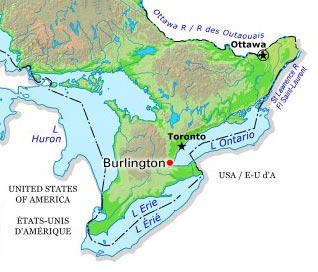
-
Article
Burnaby
Burnaby, BC, incorporated as a city in 1992, population 249,125 (2021 census), 232,755 (2016 census). Burnaby adjoins Vancouver on the west, Coquitlam on the east and New Westminster on the southeast. Named after Robert Burnaby, a businessman and legislator of the 1860s, it features Burnaby Mountain (365 m), Burnaby Lake, the Fraser River and Burrard Inlet. Burnaby was a district municipality for one hundred years before being granted civic status in 1992. It is governed by a mayor and eight councillors and is a member Metro Vancouver. (See also Municipal Government in Canada.)
"https://d2ttikhf7xbzbs.cloudfront.net/media/media/2bd7362f-7692-4d30-b07f-0cde82e5492a.jpg" // resources/views/front/categories/view.blade.php
https://d2ttikhf7xbzbs.cloudfront.net/media/media/2bd7362f-7692-4d30-b07f-0cde82e5492a.jpg
-
Article
Burns Lake
Burns Lake, BC, incorporated as a village in 1923, population 2029 (2011c), 2107 (2006c). The Village of Burns Lake is located on Highway 16 in the geographical centre of British Columbia on the Nechako Plateau, 226 km west of Prince George.
"https://development.thecanadianencyclopedia.ca/images/tce_placeholder.jpg?v=e9dca980c9bdb3aa11e832e7ea94f5d9" // resources/views/front/categories/view.blade.php
https://development.thecanadianencyclopedia.ca/images/tce_placeholder.jpg?v=e9dca980c9bdb3aa11e832e7ea94f5d9
-
Article
Burwash Landing
Burwash Landing,Yukon, settlement, population 72 (2016census), 95 (2011 census). The settlement of Burwash Landing is located on the northwest shore of Kluane Lake at Mile 1095 of theAlaska Highway.
"https://development.thecanadianencyclopedia.ca/images/tce_placeholder.jpg?v=e9dca980c9bdb3aa11e832e7ea94f5d9" // resources/views/front/categories/view.blade.php
https://development.thecanadianencyclopedia.ca/images/tce_placeholder.jpg?v=e9dca980c9bdb3aa11e832e7ea94f5d9
-
Article
Cabbagetown
Cabbagetown, a district in east-central Toronto, the general boundaries of which are the Don River on the east, Parliament St on the west, Gerrard St on the north, and Queen St on the south.
"https://development.thecanadianencyclopedia.ca/images/tce_placeholder.jpg?v=e9dca980c9bdb3aa11e832e7ea94f5d9" // resources/views/front/categories/view.blade.php
https://development.thecanadianencyclopedia.ca/images/tce_placeholder.jpg?v=e9dca980c9bdb3aa11e832e7ea94f5d9
-
Article
Cache Creek
Cache Creek, BC, incorporated as a village in 1967, population 1040 (2011c), 1056 (2001c). The Village of Cache Creek is located in the dry belt of the southern interior of British Columbia at the junction of highways 1 and 97, 84 km west of KAMLOOPS.
"https://development.thecanadianencyclopedia.ca/images/tce_placeholder.jpg?v=e9dca980c9bdb3aa11e832e7ea94f5d9" // resources/views/front/categories/view.blade.php
https://development.thecanadianencyclopedia.ca/images/tce_placeholder.jpg?v=e9dca980c9bdb3aa11e832e7ea94f5d9