Browse "Geographical features"
-
Article
Okanagan Valley
The Okanagan Valley is in south-central British Columbia, extending about 200 km north from the American border.
"https://d2ttikhf7xbzbs.cloudfront.net/media/media/4c55a3e5-810a-4ea3-b81d-24da77ff3b7c.jpg" // resources/views/front/categories/view.blade.php
https://d2ttikhf7xbzbs.cloudfront.net/media/media/4c55a3e5-810a-4ea3-b81d-24da77ff3b7c.jpg
-
Article
Old Crow Basin
Old Crow Basin is an important geographic feature in the natural history and human history of Canada
"https://d2ttikhf7xbzbs.cloudfront.net/media/media/3372115f-2e5f-492c-a1d9-de73d4668939.jpg" // resources/views/front/categories/view.blade.php
https://d2ttikhf7xbzbs.cloudfront.net/media/media/3372115f-2e5f-492c-a1d9-de73d4668939.jpg
-
Article
Old Crow Plain
The vegetation is of the tundra type, with outliers of the boreal spruce forest; willow thickets line the course of the Old Crow River.
"https://d2ttikhf7xbzbs.cloudfront.net/media/media/3372115f-2e5f-492c-a1d9-de73d4668939.jpg" // resources/views/front/categories/view.blade.php
https://d2ttikhf7xbzbs.cloudfront.net/media/media/3372115f-2e5f-492c-a1d9-de73d4668939.jpg
-
Article
Ontario's Greenbelt
Ontario’s Greenbelt, also known as the Greater Golden Horseshoe Greenbelt, is about 800,000 hectares of permanently protected green space and farmland in Ontario. It is one of many prominent greenbelts worldwide, including the British Columbia Agricultural Land Reserve in Canada and greenbelts in Copenhagen, Brazil, London, England and elsewhere. The Greenbelt forms a “belt” around the Greater Golden Horseshoe, Canada’s most densely populated area. The region includes municipalities such as Toronto, Oakville, Pickering, Hamilton, and Mississauga and stretches from Rice Lake in the east to the Niagara River in the west. The Greenbelt was created in 2005 to protect high-quality farmland and environmentally sensitive features like forests, lakes and sensitive species from urban sprawl and development.
"https://d2ttikhf7xbzbs.cloudfront.net/greenbelt/oak-ridges-moraine.jpg" // resources/views/front/categories/view.blade.php
https://d2ttikhf7xbzbs.cloudfront.net/greenbelt/oak-ridges-moraine.jpg
-
Article
Pacific Rim
The term Pacific Rim has been used to refer to all those countries with coastlines bordering the Pacific Ocean. However, in recent years the term has become synonymous with the Asia Pacific region which encompasses East and Southeast Asia, South Asia, Australia, New Zealand and North America.
"https://development.thecanadianencyclopedia.ca/images/tce_placeholder.jpg?v=e9dca980c9bdb3aa11e832e7ea94f5d9" // resources/views/front/categories/view.blade.php
https://development.thecanadianencyclopedia.ca/images/tce_placeholder.jpg?v=e9dca980c9bdb3aa11e832e7ea94f5d9
-
Article
Parry Channel
Parry Channel is a sea passage running east to west through the arctic islands.
"https://development.thecanadianencyclopedia.ca/images/tce_placeholder.jpg?v=e9dca980c9bdb3aa11e832e7ea94f5d9" // resources/views/front/categories/view.blade.php
https://development.thecanadianencyclopedia.ca/images/tce_placeholder.jpg?v=e9dca980c9bdb3aa11e832e7ea94f5d9
-
Article
Parry Islands
The Parry Islands are a group of high arctic islands comprising Melville, Bathurst and Cornwallis islands, as well as a number of smaller ones. Melville is the largest of the 3 main islands and is also the highest, exceeding 1000 m in places.
"https://development.thecanadianencyclopedia.ca/images/tce_placeholder.jpg?v=e9dca980c9bdb3aa11e832e7ea94f5d9" // resources/views/front/categories/view.blade.php
https://development.thecanadianencyclopedia.ca/images/tce_placeholder.jpg?v=e9dca980c9bdb3aa11e832e7ea94f5d9
-
Article
Partridge Island
Partridge Island is located in the Bay of Fundy, about 1 km from the shoreline and the city of Saint John, New Brunswick. The island was set aside as a quarantine station in 1785 and operated as such between 1830 and 1941. Many immigrants arriving to Canada by ship, including thousands of Irish in 1847, were isolated on the island before being allowed to enter the country. This was done in an effort to prevent the spread of infectious diseases common on overcrowded vessels. In 1974, the Partridge Island quarantine station was designated a national historic site. Other important events are associated with the island, including the installation of the world’s first steam-operated fog alarm in 1859 (see also Robert Foulis).
"https://d2ttikhf7xbzbs.cloudfront.net/media/media/0332fe7a-6266-457b-b839-06a558ff5047.jpg" // resources/views/front/categories/view.blade.php
https://d2ttikhf7xbzbs.cloudfront.net/media/media/0332fe7a-6266-457b-b839-06a558ff5047.jpg
-
Article
Passamaquoddy Bay
Passamaquoddy Bay is a small inlet near the mouth of the Bay of Fundy. Its mouth is restricted by a chain of islands, including Deer and Campobello, and strong tides (range 8.3 m) prevail in the region.
"https://development.thecanadianencyclopedia.ca/images/tce_placeholder.jpg?v=e9dca980c9bdb3aa11e832e7ea94f5d9" // resources/views/front/categories/view.blade.php
https://development.thecanadianencyclopedia.ca/images/tce_placeholder.jpg?v=e9dca980c9bdb3aa11e832e7ea94f5d9
-
Article
Peace River
Peace River, 1,923 km long, is one of the principal tributaries of the Mackenzie River system. The name of the river refers to a settlement between Cree and Dane-Zaa (Beaver) warring parties around 1781 at Peace Point at the lower portion of the river. The Dane-Zaa word for the river is unchaga, meaning “big river”; the Cree word for the settlement there is sâkitawâhk.
"https://d2ttikhf7xbzbs.cloudfront.net/media/media/1086px-Sagitawa_Lookout,_Peace_River,_Alberta.jpg" // resources/views/front/categories/view.blade.php
https://d2ttikhf7xbzbs.cloudfront.net/media/media/1086px-Sagitawa_Lookout,_Peace_River,_Alberta.jpg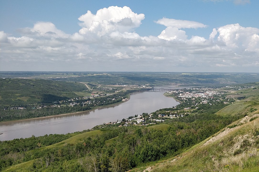
-
Article
Peace River Lowland
The Peace River Lowland is a gently rolling lowland without clearly defined outer boundaries, extending east of the Rocky Mountains on both sides of the Peace River, sloping downward to the north and east.
"https://d2ttikhf7xbzbs.cloudfront.net/media/media/13c13382-db21-45b1-a110-45d06d282f6e.jpg" // resources/views/front/categories/view.blade.php
https://d2ttikhf7xbzbs.cloudfront.net/media/media/13c13382-db21-45b1-a110-45d06d282f6e.jpg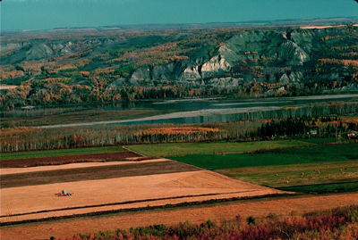
-
Article
Percé Rock
Percé Rock (or Rocher Percé) is a monolith off the Gaspé Peninsula, 750 km east of Québec City, near its namesake, the town of Percé.
"https://d2ttikhf7xbzbs.cloudfront.net/media/media/ad3866be-b4ea-484b-a7c6-4e112b36cf85.jpg" // resources/views/front/categories/view.blade.php
https://d2ttikhf7xbzbs.cloudfront.net/media/media/ad3866be-b4ea-484b-a7c6-4e112b36cf85.jpg
-
Article
Pine Pass
Pine Pass, elevation 874 m, crosses the continental divide northwest-southeast in northeastern BC. The Pine River rises southwest of the pass then flows northwest to meet the Peace River, near Fort St John.
"https://development.thecanadianencyclopedia.ca/images/tce_placeholder.jpg?v=e9dca980c9bdb3aa11e832e7ea94f5d9" // resources/views/front/categories/view.blade.php
https://development.thecanadianencyclopedia.ca/images/tce_placeholder.jpg?v=e9dca980c9bdb3aa11e832e7ea94f5d9
-
Article
Placentia Bay
Placentia Bay, from the French plaisance (meaning a "pleasant place"), is a large, deep bay formed by Newfoundland's Burin Peninsula to the west, and the southwestern Avalon Peninsula to the east.
"https://d2ttikhf7xbzbs.cloudfront.net/media/media/1156688e-36f0-43f0-b71a-c95ed49e88d0.jpg" // resources/views/front/categories/view.blade.php
https://d2ttikhf7xbzbs.cloudfront.net/media/media/1156688e-36f0-43f0-b71a-c95ed49e88d0.jpg
-
Article
Port-au-Port Peninsula
Port-au-Port peninsula is a roughly triangular peninsula with 130 km of rocky coastline but no harbours. The peninsula is joined to southwestern Newfoundland via a strip of land west of Stephenville. Port-au-Port is home to Newfoundland’s oldest francophone communities (see Francophones of Newfoundland and Labrador).
"https://development.thecanadianencyclopedia.ca/images/tce_placeholder.jpg?v=e9dca980c9bdb3aa11e832e7ea94f5d9" // resources/views/front/categories/view.blade.php
https://development.thecanadianencyclopedia.ca/images/tce_placeholder.jpg?v=e9dca980c9bdb3aa11e832e7ea94f5d9