Browse "Geographical features"
-
Article
Davis Strait
Some of the greatest depths in the eastern Arctic are reached here (3660 m) in the southern end of the strait. The surface waters are strongly affected by counterclockwise-flowing currents.
"https://d2ttikhf7xbzbs.cloudfront.net/media/media/9669519f-2a3e-42ad-83f1-b803cd3cf07b.jpg" // resources/views/front/categories/view.blade.php
https://d2ttikhf7xbzbs.cloudfront.net/media/media/9669519f-2a3e-42ad-83f1-b803cd3cf07b.jpg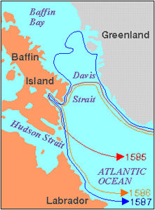
-
Article
Dean River
Dean River, 241 km long, world-famous steelhead- and salmon-fishing stream, rises in the Fraser Plateau of west-central BC, flows northwest and west through the COAST MOUNTAINS and empties near the head of Dean Channel.
"https://development.thecanadianencyclopedia.ca/images/tce_placeholder.jpg?v=e9dca980c9bdb3aa11e832e7ea94f5d9" // resources/views/front/categories/view.blade.php
https://development.thecanadianencyclopedia.ca/images/tce_placeholder.jpg?v=e9dca980c9bdb3aa11e832e7ea94f5d9
-
Article
Deer Island
Deer Island abuts the border with the US at the entrance to Passamaquoddy Bay on the south coast of New Brunswick. Long in dispute with the US, sovereignty over the island passed to NB in 1817. The name is probably descriptive. Fishing is the most important economic activity.
"https://development.thecanadianencyclopedia.ca/images/tce_placeholder.jpg?v=e9dca980c9bdb3aa11e832e7ea94f5d9" // resources/views/front/categories/view.blade.php
https://development.thecanadianencyclopedia.ca/images/tce_placeholder.jpg?v=e9dca980c9bdb3aa11e832e7ea94f5d9
-
"https://development.thecanadianencyclopedia.ca/images/tce_placeholder.jpg?v=e9dca980c9bdb3aa11e832e7ea94f5d9" // resources/views/front/categories/view.blade.php
https://development.thecanadianencyclopedia.ca/images/tce_placeholder.jpg?v=e9dca980c9bdb3aa11e832e7ea94f5d9
-
Article
Delta (Landform)
A delta is a deposit of sediment at the mouth of a river that accumulates as the river flows into a standing body of water such as a lake or ocean. Because sediment tends to be rich in nutrients, deltas become fertile wetlands inhabited by diverse wildlife. Among the largest deltas in Canada are those of the Mackenzie and Saskatchewan rivers, as well as the Peace-Athabasca Delta (where the Peace, Athabasca and Birch rivers meet). Certain deltas offer advantageous access to natural resources and maritime transportation, but development projects are often controversial due to the ecological importance of these environments.
"https://d2ttikhf7xbzbs.cloudfront.net/media/media/293454d6-184b-47a4-b934-b91879492e33.jpg" // resources/views/front/categories/view.blade.php
https://d2ttikhf7xbzbs.cloudfront.net/media/media/293454d6-184b-47a4-b934-b91879492e33.jpg
-
"https://d2ttikhf7xbzbs.cloudfront.net/media/media/57efb97e-fd6e-4a08-85d6-ce216c441360.jpg" // resources/views/front/categories/view.blade.php
https://d2ttikhf7xbzbs.cloudfront.net/media/media/57efb97e-fd6e-4a08-85d6-ce216c441360.jpg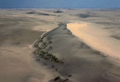
-
Article
Detroit River
The Detroit River, 52 km long, flows south from Lake ST CLAIR to the west end of Lake ERIE, forming part of the boundary between Ontario and Michigan. Detroit, Michigan, and WINDSOR, Ontario, dominate its shores. Part of the ST LAWRENCE SEAWAY, it is heavily used by commercial traffic.
"https://development.thecanadianencyclopedia.ca/images/tce_placeholder.jpg?v=e9dca980c9bdb3aa11e832e7ea94f5d9" // resources/views/front/categories/view.blade.php
https://development.thecanadianencyclopedia.ca/images/tce_placeholder.jpg?v=e9dca980c9bdb3aa11e832e7ea94f5d9
-
Article
Devon Island
The Truelove Lowland area of the island has diverse vegetation and wildlife, an abundance of soil water in the summer owing to blocked drainage, and greater precipitation and higher summer temperatures (4° to 8°C), with more clear days than other parts of the island.
"https://d2ttikhf7xbzbs.cloudfront.net/media/media/4aad02e3-72bd-400c-87ab-d1380ccad4dc.jpg" // resources/views/front/categories/view.blade.php
https://d2ttikhf7xbzbs.cloudfront.net/media/media/4aad02e3-72bd-400c-87ab-d1380ccad4dc.jpg
-
Article
Devon Island Miocene Fossils
FOSSIL bones were first discovered in 1978 in the rocks formed in the now vanished Haughton Lake.
"https://development.thecanadianencyclopedia.ca/images/tce_placeholder.jpg?v=e9dca980c9bdb3aa11e832e7ea94f5d9" // resources/views/front/categories/view.blade.php
https://development.thecanadianencyclopedia.ca/images/tce_placeholder.jpg?v=e9dca980c9bdb3aa11e832e7ea94f5d9
-
Article
Dixon Entrance
Dixon Entrance is a strait between Haida Gwaii on the north coast of British Columbia and Prince of Wales and Dall islands in Alaska.
"https://development.thecanadianencyclopedia.ca/images/tce_placeholder.jpg?v=e9dca980c9bdb3aa11e832e7ea94f5d9" // resources/views/front/categories/view.blade.php
https://development.thecanadianencyclopedia.ca/images/tce_placeholder.jpg?v=e9dca980c9bdb3aa11e832e7ea94f5d9
-
Article
Drainage Basin
A drainage basin is an area of land that contributes the water it receives as precipitation to a river or network of rivers.
"https://development.thecanadianencyclopedia.ca/images/tce_placeholder.jpg?v=e9dca980c9bdb3aa11e832e7ea94f5d9" // resources/views/front/categories/view.blade.php
https://development.thecanadianencyclopedia.ca/images/tce_placeholder.jpg?v=e9dca980c9bdb3aa11e832e7ea94f5d9
-
Editorial
Drought in Palliser's Triangle
The following article is an editorial written by The Canadian Encyclopedia staff. Editorials are not usually updated.
"https://development.thecanadianencyclopedia.ca/images/tce_placeholder.jpg?v=e9dca980c9bdb3aa11e832e7ea94f5d9" // resources/views/front/categories/view.blade.php
https://development.thecanadianencyclopedia.ca/images/tce_placeholder.jpg?v=e9dca980c9bdb3aa11e832e7ea94f5d9
-
Article
Dubawnt Lake
Dubawnt Lake, 3833 km2, elevation 236 m, is situated in the southern part of mainland Nunavut, 350 km south of the Arctic Circle. Within the Precambrian SHIELD, the lake has irregular shorelines and numerous islands.
"https://development.thecanadianencyclopedia.ca/images/tce_placeholder.jpg?v=e9dca980c9bdb3aa11e832e7ea94f5d9" // resources/views/front/categories/view.blade.php
https://development.thecanadianencyclopedia.ca/images/tce_placeholder.jpg?v=e9dca980c9bdb3aa11e832e7ea94f5d9
-
Article
Dubawnt River
Dubawnt River, 842 km long, rises from a web of lakes in the Northwest Territories, 120 km northeast of Lake Athabasca, flows northeast, gathering the waters of Wholdaia, Boyd, Barlow, Nicholson, Dubawnt, Wharton and Marjorie lakes, and turns abruptly northwest to join the Thelon River at Beverly Lake.
"https://development.thecanadianencyclopedia.ca/images/tce_placeholder.jpg?v=e9dca980c9bdb3aa11e832e7ea94f5d9" // resources/views/front/categories/view.blade.php
https://development.thecanadianencyclopedia.ca/images/tce_placeholder.jpg?v=e9dca980c9bdb3aa11e832e7ea94f5d9
-
Article
Eagle Pass
Eagle Pass, elevation about 550 m, provides a corridor through the Gold Range in the Monashee Mountains between Shuswap Lake and the Columbia River, 12 km southwest of Revelstoke, British Columbia.
"https://d2ttikhf7xbzbs.cloudfront.net/media/media/1f3712f0-f1ac-4fba-a093-ff4c7cfec856.jpg" // resources/views/front/categories/view.blade.php
https://d2ttikhf7xbzbs.cloudfront.net/media/media/1f3712f0-f1ac-4fba-a093-ff4c7cfec856.jpg