Article
Rivière Koksoak
Koksoak, Rivière, 874 km long (to head of Caniapiscau River), final leg of a river system that drains a vast area (133 000 km2) of northern Québec.
Signing up enhances your TCE experience with the ability to save items to your personal reading list, and access the interactive map.
Create AccountArticle
Koksoak, Rivière, 874 km long (to head of Caniapiscau River), final leg of a river system that drains a vast area (133 000 km2) of northern Québec.
"https://development.thecanadianencyclopedia.ca/images/tce_placeholder.jpg?v=e9dca980c9bdb3aa11e832e7ea94f5d9" // resources/views/front/categories/view.blade.phphttps://development.thecanadianencyclopedia.ca/images/tce_placeholder.jpg?v=e9dca980c9bdb3aa11e832e7ea94f5d9

Article
The Rivière Manicouagan, 560 km long, rises in east-central Québec near the Labrador border and flows south through the Réservoir Manicouagan to the St Lawrence River near Baie-Comeau.
"https://d2ttikhf7xbzbs.cloudfront.net/media/media/6be9c93a-1849-439f-b16a-f87c91691760.jpg" // resources/views/front/categories/view.blade.phphttps://d2ttikhf7xbzbs.cloudfront.net/media/media/6be9c93a-1849-439f-b16a-f87c91691760.jpg

Article
Rivière Moisie, 410 km long, rises in eastern Québec from Lac Opocopa and flows south to the St. Lawrence River. With a drainage basin of 19,200 km2 and a mean discharge of 490 m3/s, it is the river of greatest volume along the middle north Shore of the St. Lawrence.
"https://development.thecanadianencyclopedia.ca/images/tce_placeholder.jpg?v=e9dca980c9bdb3aa11e832e7ea94f5d9" // resources/views/front/categories/view.blade.phphttps://development.thecanadianencyclopedia.ca/images/tce_placeholder.jpg?v=e9dca980c9bdb3aa11e832e7ea94f5d9
Article
Rivière Nottaway, 776 km (via Rivière Bell to head of Rivière Mégiscane), rises in west-central Québec and flows north via Lacs Parent and Quévillon into Lac Matagami. Here it is joined by its chief headstream, Rivière Waswanipi, and then drains northwest through Lac Soscumica.
"https://development.thecanadianencyclopedia.ca/images/tce_placeholder.jpg?v=e9dca980c9bdb3aa11e832e7ea94f5d9" // resources/views/front/categories/view.blade.phphttps://development.thecanadianencyclopedia.ca/images/tce_placeholder.jpg?v=e9dca980c9bdb3aa11e832e7ea94f5d9
Article
The Richelieu River has played a prominent role in the historical development of Québec. Originally inhabited by Iroquois, Huron and Algonquin, Samuel de CHAMPLAIN navigated its waters shortly after his arrival in 1608.
"https://d2ttikhf7xbzbs.cloudfront.net/media/media/eb8d4d81-eea3-4fe3-b07d-149f6170ebbf.jpg" // resources/views/front/categories/view.blade.phphttps://d2ttikhf7xbzbs.cloudfront.net/media/media/eb8d4d81-eea3-4fe3-b07d-149f6170ebbf.jpg
Article
Rivière Romaine, 496 km long with a 14 350 km2 basin, rises (elev 760 m) in the Québec-Labrador lacustrine plateau, 45 km southwest of the CHURCHILL RIVER, and forms part of the Québec-Labrador boundary north of the 52nd parallel.
"https://development.thecanadianencyclopedia.ca/images/tce_placeholder.jpg?v=e9dca980c9bdb3aa11e832e7ea94f5d9" // resources/views/front/categories/view.blade.phphttps://development.thecanadianencyclopedia.ca/images/tce_placeholder.jpg?v=e9dca980c9bdb3aa11e832e7ea94f5d9
Article
The Rouge River is a tributary of the Ottawa River. Its source is Lac de la Fougère, in the northeast part of Rouge-Matawin Wildlife Reserve in Québec.
"https://d2ttikhf7xbzbs.cloudfront.net/media/media/6953ea93-69d2-40dd-a80d-f44f0be8c655.JPG" // resources/views/front/categories/view.blade.phphttps://d2ttikhf7xbzbs.cloudfront.net/media/media/6953ea93-69d2-40dd-a80d-f44f0be8c655.JPG

Article
Rivière Saint-François, 280 km long, drainage basin 10 230 km2, is located in southern Québec.
"https://development.thecanadianencyclopedia.ca/images/tce_placeholder.jpg?v=e9dca980c9bdb3aa11e832e7ea94f5d9" // resources/views/front/categories/view.blade.phphttps://development.thecanadianencyclopedia.ca/images/tce_placeholder.jpg?v=e9dca980c9bdb3aa11e832e7ea94f5d9
Article
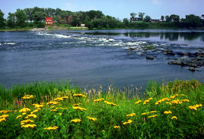
Rivière Saint-Maurice, 563 km long, rises upstream from Réservoir Gouin, 200 km west of Lac Saint-Jean, Québec. It drains a basin of 43 300 km2. After its confluence with Rivière Manouane, it feeds Réservoir Blanc and then takes in the Vermillon, Trenche, Croche, Mattawin and Mékinac rivers.
"https://d2ttikhf7xbzbs.cloudfront.net/media/media/26ddf9e4-78b9-4850-b1ab-94971048ce2e.jpg" // resources/views/front/categories/view.blade.phphttps://d2ttikhf7xbzbs.cloudfront.net/media/media/26ddf9e4-78b9-4850-b1ab-94971048ce2e.jpg

Article
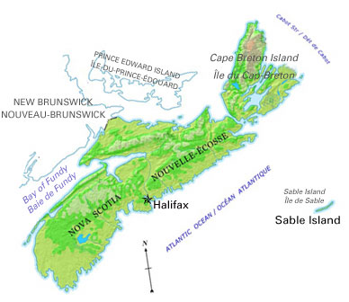
The Rocky Mountain Trench is a long and deep valley extending approximately 1,500 km from the Bitterroot Valley in northwest Montana through British Columbia to the Liard Plain just south of the Yukon Territory. Its predominantly flat floor is 3–20 km wide and ranges in elevation between 600 m and 1,000 m above sea level. With walls made of sedimentary, volcanic and igneous rock, the Trench is sometimes referred to as the “Valley of a Thousand Peaks” because of the towering mountain ranges on either side: the Rocky Mountains to the east and the Columbia, Omineca and Cassiar mountains to the west. Humans have relied on the rich resources provided by this distinctive landscape from pre-colonial times to the present.
"https://d2ttikhf7xbzbs.cloudfront.net/media/media/061fe992-a3bf-45bc-906d-216d1bef45c7.jpg" // resources/views/front/categories/view.blade.phphttps://d2ttikhf7xbzbs.cloudfront.net/media/media/061fe992-a3bf-45bc-906d-216d1bef45c7.jpg

Article
Castlelike mountain resorts built on the rail line at Banff and Lake Louise have become all-season recreation centres for Banff National Park's (established 1885) many alpine attractions, which attract 4.5 million visitors annually.
"https://d2ttikhf7xbzbs.cloudfront.net/media/media/ebac2147-4f0e-4324-844b-afdbfd364b52.jpg" // resources/views/front/categories/view.blade.phphttps://d2ttikhf7xbzbs.cloudfront.net/media/media/ebac2147-4f0e-4324-844b-afdbfd364b52.jpg

Article
Rupert’s Land was a vast territory of northern wilderness. It represented a third of what is now Canada. From 1670 to 1870, it was the exclusive commercial domain of the Hudson’s Bay Company(HBC) and the primary trapping grounds of the fur trade. The territory was named after Prince Rupert, the HBC’s first governor. Three years after Confederation, the Government of Canada acquired Rupert’s Land from the HBC for CAD$1.5-million (£300,000). It is the largest real estate transaction (by land area) in the country’s history. The purchase of Rupert’s Land transformed Canada geographically. It changed from a modest country in the northeast of the continent into an expansive one that reached across North America. Rupert’s Land was eventually divided among Quebec, Ontario, Manitoba, Saskatchewan, Alberta and the Northwest Territories.
"https://d2ttikhf7xbzbs.cloudfront.net/media/media/2e0091d5-aa3e-4656-b4b6-2a1948aff9d7.jpg" // resources/views/front/categories/view.blade.phphttps://d2ttikhf7xbzbs.cloudfront.net/media/media/2e0091d5-aa3e-4656-b4b6-2a1948aff9d7.jpg

Article
Saanich Peninsula, BC, forms part of the Nanaimo Lowlands, along Vancouver Island's east coast. It extends from Sidney in the north to Victoria in the south, and is 33 km long and averages 4 km in width; 90 per cent of its perimeter is fronted by sea. The dominant geographical features are Mount Newton and Saanich Inlet.
"https://development.thecanadianencyclopedia.ca/images/tce_placeholder.jpg?v=e9dca980c9bdb3aa11e832e7ea94f5d9" // resources/views/front/categories/view.blade.phphttps://development.thecanadianencyclopedia.ca/images/tce_placeholder.jpg?v=e9dca980c9bdb3aa11e832e7ea94f5d9
Article
Shaped like an open crescent, 35 km long and 1.6 km wide at its widest point, it narrows at both ends to West and East Spits, which continue offshore as shallow submerged bars.
"https://d2ttikhf7xbzbs.cloudfront.net/media/media/6607c641-cc62-438d-b372-fcea498c311b.jpg" // resources/views/front/categories/view.blade.phphttps://d2ttikhf7xbzbs.cloudfront.net/media/media/6607c641-cc62-438d-b372-fcea498c311b.jpg
Article
Saint John River, 673 km long, rises in northern Maine and flows northeast into the forests of Madawaska County to Edmundston, where it is joined by the Madawaska River and turns southeast, forming much of the border between Maine and New Brunswick. Saint John River is known as the Wolastoq by the Wolastoqiyik people, which means “beautiful river” in their language.
"https://d2ttikhf7xbzbs.cloudfront.net/media/media/150b0699-4963-43be-ada6-fe736bf4d819.jpg" // resources/views/front/categories/view.blade.phphttps://d2ttikhf7xbzbs.cloudfront.net/media/media/150b0699-4963-43be-ada6-fe736bf4d819.jpg
