Browse "Parks & Nature Reserves"
-
Article
National Parks of Canada
Canada’s national parks are protected areas established under federal legislation to preserve Canada’s natural heritage. They are administered by Parks Canada, a government agency that evolved from the world’s first national parks service, the Dominion Parks Branch, established in 1911. The National Parks System Plan, developed in 1970, divided Canada into 39 natural regions and set the goal of representing each region with at least one national park. Canada now has 48 national parks and national park reserves, and one national urban park, in 30 of these regions. In total, the parks cover more than 340,000 km2, which is over 3 per cent of Canada’s landmass. They protect important land and marine habitats, geographical features and sites of cultural significance. National parks also benefit local economies and the tourism industry in Canada. (This is the full-length entry about National Parks of Canada. For a plain-language summary, please see National Parks of Canada (Plain-Language Summary).)
"https://d2ttikhf7xbzbs.cloudfront.net/media/media/27f9bb3e-3454-4b12-9aca-ded0299bfe8c.jpg" // resources/views/front/categories/view.blade.php
https://d2ttikhf7xbzbs.cloudfront.net/media/media/27f9bb3e-3454-4b12-9aca-ded0299bfe8c.jpg
-
search.types.interactivemap
National Parks of Canada Interactive Map
The map below indicates the location of national parks and national park reserves in Canada. Click on individual points to learn a park’s name and the year it was established. Canada’s national parks and national park reserves are protected areas established under federal legislation. They aim to preserve Canada’s natural heritage. There are 48 national parks and national park reserves in Canada, and one national urban park. (See also National Parks of Canada)
"https://d2ttikhf7xbzbs.cloudfront.net/media/new_article_images/NationalParksInteractiveMap/NationalParksofCanadaScreenShot.png" // resources/views/front/categories/view.blade.php
https://d2ttikhf7xbzbs.cloudfront.net/media/new_article_images/NationalParksInteractiveMap/NationalParksofCanadaScreenShot.png
-
Article
Notikewin Provincial Park
Interest from local residents led to the establishment of Notikewin Provincial Park (established 1979, 97 km2). Here is preserved a small piece of the quintessential natural landscape of northern Alberta, the once endless poplar and spruce forests deeply dissected by moody rivers.
"https://development.thecanadianencyclopedia.ca/images/tce_placeholder.jpg?v=e9dca980c9bdb3aa11e832e7ea94f5d9" // resources/views/front/categories/view.blade.php
https://development.thecanadianencyclopedia.ca/images/tce_placeholder.jpg?v=e9dca980c9bdb3aa11e832e7ea94f5d9
-
Article
Notre Dame Provincial Park
Nestled in the lush forests of central Newfoundland, Notre Dame Provincial Park (established 1959, 113 ha) borders on the serene waters of Junction Pond.
"https://development.thecanadianencyclopedia.ca/images/tce_placeholder.jpg?v=e9dca980c9bdb3aa11e832e7ea94f5d9" // resources/views/front/categories/view.blade.php
https://development.thecanadianencyclopedia.ca/images/tce_placeholder.jpg?v=e9dca980c9bdb3aa11e832e7ea94f5d9
-
Article
Nunavik
Nunavik, the portion of land within the province of Quebec located north of the 55th parallel, covers approximately 500,000 km2 (representing more than one-third of Quebec’s territory). For approximately 4,000 years, Indigenous people have inhabited Nunavik, including Inuit who have made the region their homeland. Today, over 13,000 people live in Nunavik’s 14 villages spread along the Ungava Bay, Hudson Strait and Eastern Hudson Bay coasts.
"https://development.thecanadianencyclopedia.ca/images/tce_placeholder.jpg?v=e9dca980c9bdb3aa11e832e7ea94f5d9" // resources/views/front/categories/view.blade.php
https://development.thecanadianencyclopedia.ca/images/tce_placeholder.jpg?v=e9dca980c9bdb3aa11e832e7ea94f5d9
-
Article
Ontario's Greenbelt
Ontario’s Greenbelt, also known as the Greater Golden Horseshoe Greenbelt, is about 800,000 hectares of permanently protected green space and farmland in Ontario. It is one of many prominent greenbelts worldwide, including the British Columbia Agricultural Land Reserve in Canada and greenbelts in Copenhagen, Brazil, London, England and elsewhere. The Greenbelt forms a “belt” around the Greater Golden Horseshoe, Canada’s most densely populated area. The region includes municipalities such as Toronto, Oakville, Pickering, Hamilton, and Mississauga and stretches from Rice Lake in the east to the Niagara River in the west. The Greenbelt was created in 2005 to protect high-quality farmland and environmentally sensitive features like forests, lakes and sensitive species from urban sprawl and development.
"https://d2ttikhf7xbzbs.cloudfront.net/greenbelt/oak-ridges-moraine.jpg" // resources/views/front/categories/view.blade.php
https://d2ttikhf7xbzbs.cloudfront.net/greenbelt/oak-ridges-moraine.jpg
-
Article
Ouimet Canyon Provincial Park
A spectacular, steep-sided gorge cut into volcanic rock of Lake Superior's northern shore is protected in Ouimet Canyon Provincial Park (established 1972, 777 ha), 65 km northeast of Thunder Bay, Ontario.
"https://d2ttikhf7xbzbs.cloudfront.net/media/media/fe2420b7-d26b-483e-b339-46a75ac65e13.jpg" // resources/views/front/categories/view.blade.php
https://d2ttikhf7xbzbs.cloudfront.net/media/media/fe2420b7-d26b-483e-b339-46a75ac65e13.jpg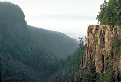
-
Article
Pacific Rim National Park Reserve
Pacific Rim National Park Reserve (est 1970, 285.8 km2) stretches for 105 km along the rugged west coast of Vancouver Island.
"https://d2ttikhf7xbzbs.cloudfront.net/media/media/14e848e6-2343-4115-a5a5-78d718430c10.jpg" // resources/views/front/categories/view.blade.php
https://d2ttikhf7xbzbs.cloudfront.net/media/media/14e848e6-2343-4115-a5a5-78d718430c10.jpg
-
Article
Parc national de la Gaspésie
In the heart of the Gaspé Peninsula, 196 km east of Rimouski, is Parc national de la Gaspésie (established 1981, 802 km2). First established in 1937 by means of special legislation, the park has in the past bowed to mining and forestry pressures. It is now completely protected through the park's Act.
"https://development.thecanadianencyclopedia.ca/images/tce_placeholder.jpg?v=e9dca980c9bdb3aa11e832e7ea94f5d9" // resources/views/front/categories/view.blade.php
https://development.thecanadianencyclopedia.ca/images/tce_placeholder.jpg?v=e9dca980c9bdb3aa11e832e7ea94f5d9
-
Article
Petroglyphs Provincial Park
Petroglyphs Provincial Park (established 1976, 1643 ha) is the site of one of Canada's archaeological and cultural treasures. On a flat expanse of rock are some 900 carvings or petroglyphs of symbolic shapes and figures, likely carved by Algonquian-speaking people. Established as a historic-class park, Petroglyphs Provincial Park is located 55 km northeast of Peterborough, Ontario. It is located on the southern edge of the Canadian Shield and in a transition zone between the Shield and the Great Lakes-St Lawrence Lowland area. Rocky ridges covered with thin soil are interspersed with low-lying wetlands.
"https://development.thecanadianencyclopedia.ca/images/tce_placeholder.jpg?v=e9dca980c9bdb3aa11e832e7ea94f5d9" // resources/views/front/categories/view.blade.php
https://development.thecanadianencyclopedia.ca/images/tce_placeholder.jpg?v=e9dca980c9bdb3aa11e832e7ea94f5d9
-
Article
Point Pelee National Park
Point Pelee National Park (established 1918) is a protected area at the tip of Point Pelee, a long peninsula extending into the western end of Lake Erie, south of Leamington, Ontario. Middle Island — Canada’s southernmost piece of land located southwest of Point Pelee — was added to the park in 2000. At 15 km2, Point Pelee National Park is Canada’s second smallest national park. It’s also the southernmost tip of Canada’s mainland, located further south than northern California.
"https://d2ttikhf7xbzbs.cloudfront.net/media/new_article_images/25942993688_275b33c77b_o.jpg" // resources/views/front/categories/view.blade.php
https://d2ttikhf7xbzbs.cloudfront.net/media/new_article_images/25942993688_275b33c77b_o.jpg
-
Article
Prince Albert National Park
Natural Heritage Bounded to the south by farmland, the park lies on a transition zone between 2 ecoregions. Pockets of aspen parkland and fescue prairie in the south of the park blend with mixed-wood and boreal forests in the park's northern reaches.
"https://d2ttikhf7xbzbs.cloudfront.net/media/media/f507b630-0ecd-47f8-b3a8-7ef49ed586c9.jpg" // resources/views/front/categories/view.blade.php
https://d2ttikhf7xbzbs.cloudfront.net/media/media/f507b630-0ecd-47f8-b3a8-7ef49ed586c9.jpg
-
Article
Prince Edward Island National Park
Prince Edward Island National Park (est 1937, 21.5 km2) is a narrow strip of coastline stretching over 40 km along the north shore of PEI.
"https://d2ttikhf7xbzbs.cloudfront.net/media/media/43c98966-afd6-46ad-88a3-937937a88fff.jpg" // resources/views/front/categories/view.blade.php
https://d2ttikhf7xbzbs.cloudfront.net/media/media/43c98966-afd6-46ad-88a3-937937a88fff.jpg
-
Article
Provincial Parks
This image of Reesor Lake in Cypress Hills Interprovincial Park depicts mixed spruce, aspen woodland and fescue grassland (photo by Cliff Wallis, courtesy Cottonwood Consultants Ltd.).Typical boreal shield country in northern Ontario (photo by Brian Milne/First Light).PreviousNext Parks, Provincial Provincial parks are areas of land and water, large or small, natural or man-modified, designated by any of the provincial governments for the purposes of nature protection, recreation, TOURISM, historic preservation and education. They range in...
"https://d2ttikhf7xbzbs.cloudfront.net/media/media/ca373d61-2489-44ec-a604-201d64f5116e.jpg" // resources/views/front/categories/view.blade.php
https://d2ttikhf7xbzbs.cloudfront.net/media/media/ca373d61-2489-44ec-a604-201d64f5116e.jpg
-
Article
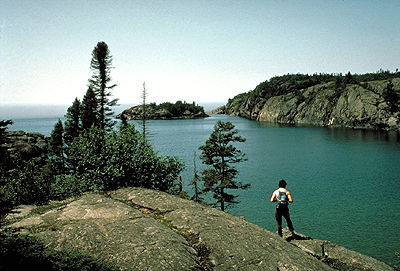
Pukaskwa National Park
Pukaskwa National Park (designated 1978, 1877.8 km2) is bracketed on the west by the coastline of Lake Superior, an impressive stretch of massive headlands and beaches of golden sand or water-worn cobble. The name is of native origin but its meaning is unclear.
"https://d2ttikhf7xbzbs.cloudfront.net/media/media/8fa1ba40-04c8-4e20-b684-d478d83147ff.jpg" // resources/views/front/categories/view.blade.php
https://d2ttikhf7xbzbs.cloudfront.net/media/media/8fa1ba40-04c8-4e20-b684-d478d83147ff.jpg