Browse "Places"
-
Article
Rebellion in Lower Canada (The Patriots' War)
In 1837 and 1838, French Canadian militants in Lower Canada took up arms against the British Crown in a pair of insurrections. The twin rebellions killed more than 300 people. They followed years of tensions between the colony’s anglophone minority and the growing, nationalistic aspirations of its francophone majority. The rebels failed in their campaign against British rule. However, their revolt led to political reform, including the unified Province of Canada and the introduction of responsible government. The rebellion in Lower Canada, which is also known as the Patriots' War (la Guerre des patriotes), also gave French Canadians one of their first nationalist heroes in Louis-Joseph Papineau.
"https://d2ttikhf7xbzbs.cloudfront.net/media/media/37aadc48-3f88-4946-a9aa-0d2ad30495cd.jpg" // resources/views/front/categories/view.blade.php
https://d2ttikhf7xbzbs.cloudfront.net/media/media/37aadc48-3f88-4946-a9aa-0d2ad30495cd.jpg
-
Article
Rebellion in Upper Canada
The 1837 rebellion in Upper Canada was a less violent, more limited affair than the uprising earlier that year in Lower Canada. However, its leaders, including William Lyon Mackenzie, were equally serious in their demands. They wanted democratic reform and an end to the rule of a privileged oligarchy. The rebellion itself failed, but its very failure helped pave the way for moderate and careful political change in British North America. This included the union of Upper and Lower Canada into the Province of Canada and the eventual introduction of responsible government.
"https://d2ttikhf7xbzbs.cloudfront.net/media/media/ab6ffbc8-72e2-4fc1-9007-43a1b2c8948d.jpg" // resources/views/front/categories/view.blade.php
https://d2ttikhf7xbzbs.cloudfront.net/media/media/ab6ffbc8-72e2-4fc1-9007-43a1b2c8948d.jpg
-
Article
Red Bay
Red Bay, NL, incorporated as a town in 1997, population 169 (2016 census), 194 (2011 census). The town of Red Bay is located on the Strait of Belle Isle, off Labrador’s south coast. Named for its prominent red cliffs, it was one of two major Basque whaling stations established in the 1540s. After research into Spanish documents and archaeological finds on Saddle Island and under water, Red Bay was designated a historical site in 1978-79 (see Red Bay Archaeological Site). In 2013, the whaling station at Red Bay was designated a UNESCO World Heritage Site.
"https://d2ttikhf7xbzbs.cloudfront.net/media/media/2d045c80-3539-44a1-a87c-7b1a734b8c91.jpg" // resources/views/front/categories/view.blade.php
https://d2ttikhf7xbzbs.cloudfront.net/media/media/2d045c80-3539-44a1-a87c-7b1a734b8c91.jpg
-
Article
Red Bay Archaeological Site
Red Bay, located on the north shore of the Strait of Belle Isle, Labrador, is an archaeological reference for the 16th-century transatlantic fishery, particularly for Basque whaling activities. After research into Spanish documents and archaeological finds on Saddle Island and under water, Red Bay was designated a historical site in 1978-79. In 2013, the whaling station at Red Bay was designated a UNESCO World Heritage Site.
"https://d2ttikhf7xbzbs.cloudfront.net/media/media/2d045c80-3539-44a1-a87c-7b1a734b8c91.jpg" // resources/views/front/categories/view.blade.php
https://d2ttikhf7xbzbs.cloudfront.net/media/media/2d045c80-3539-44a1-a87c-7b1a734b8c91.jpg
-
Article
Red Deer
Red Deer, Alberta, incorporated as a city in 1913, population 100,844 (2021 census), 100,418 (2016 census). The city of Red Deer is located on the Red Deer River, 150 km south of Edmonton. The Cree applied the name “Elk” to the river, but Scottish fur traders appear to have confused elk with the red deer of their homeland.
"https://development.thecanadianencyclopedia.ca/images/tce_placeholder.jpg?v=e9dca980c9bdb3aa11e832e7ea94f5d9" // resources/views/front/categories/view.blade.php
https://development.thecanadianencyclopedia.ca/images/tce_placeholder.jpg?v=e9dca980c9bdb3aa11e832e7ea94f5d9
-
Article
Red Deer River
The Red Deer River (740 km, mean annual flow rate 62 m3/s), is glacier-fed by streams from Mount Drummond and Cyclone Mountain in the Rockies of Banff National Park in Alberta. It flows east then south to join the South SASKATCHEWAN RIVER just inside Saskatchewan.
"https://development.thecanadianencyclopedia.ca/images/tce_placeholder.jpg?v=e9dca980c9bdb3aa11e832e7ea94f5d9" // resources/views/front/categories/view.blade.php
https://development.thecanadianencyclopedia.ca/images/tce_placeholder.jpg?v=e9dca980c9bdb3aa11e832e7ea94f5d9
-
Article
Red Lake
Red Lake, Ontario, incorporated as a municipality in 1998, population 4,094 (2021 census), 4,107 (2016 census). The municipality of Red Lake is located in northwestern Ontario on the shore of Red Lake, 555 km northwest of Thunder Bay. The municipality is the result of the amalgamation of the former townships of Red Lake (incorporated in 1960) and Golden (established in 1985), and the unorganized territory governed by the Madsen local services board. Red Lake consists of six communities (Madsen, Red Lake, Balmertown, Cochenour, McKenzie Island and Starratt-Olsen) that sprang up around the area's gold mines.
"https://development.thecanadianencyclopedia.ca/images/tce_placeholder.jpg?v=e9dca980c9bdb3aa11e832e7ea94f5d9" // resources/views/front/categories/view.blade.php
https://development.thecanadianencyclopedia.ca/images/tce_placeholder.jpg?v=e9dca980c9bdb3aa11e832e7ea94f5d9
-
Article
Red River
The Red River (880 km long) begins at the confluence of the Bois de Sioux and Otter Tail rivers at the border between Minnesota and North Dakota. It then flows north through southern Manitoba and into Lake Winnipeg. The last 175 km of the Red River, the portion located in Manitoba, is designated as a Canadian Heritage River due to its cultural and historical value. The Red River flows through a productive agricultural region that is prone to both drought and severe flooding — the largest flood in the area in recent history, coined “the flood of the century,” occurred in 1997. The river’s basin was once the bottom of a glacial lake, Lake Agassiz, which covered the region 8,000 years ago. Currently, the Red River provides water for municipal, industrial and agricultural uses, and offers numerous summer and winter recreational opportunities, including boating, fishing (including ice fishing), camping and skating.
"https://d2ttikhf7xbzbs.cloudfront.net/media/media/c61bdc21-634f-4316-9ab1-acb89adc0cdf.jpg" // resources/views/front/categories/view.blade.php
https://d2ttikhf7xbzbs.cloudfront.net/media/media/c61bdc21-634f-4316-9ab1-acb89adc0cdf.jpg
-
Article
Red River Resistance
The Red River Resistance (also known as the Red River Rebellion) was an uprising in 1869–70 in the Red River Colony. The resistance was sparked by the transfer of the vast territory of Rupert’s Land to the new Dominion of Canada. The colony of farmers and hunters, many of them Métis, occupied a corner of Rupert’s Land and feared for their culture and land rights under Canadian control. The Métis mounted a resistance and declared a provisional government to negotiate terms for entering Confederation. The uprising led to the creation of the province of Manitoba, and the emergence of Métis leader Louis Riel — a hero to his people and many in Quebec, but an outlaw in the eyes of the Canadian government.
"https://d2ttikhf7xbzbs.cloudfront.net/media/media/f0a1f84f-c420-4038-8815-42587e295b75.jpg" // resources/views/front/categories/view.blade.php
https://d2ttikhf7xbzbs.cloudfront.net/media/media/f0a1f84f-c420-4038-8815-42587e295b75.jpg
-
Article
Redcliff
Redcliff, Alta, incorporated as a town in 1912, population 5588 (2011c), 5116 (2006c). The Town of Redcliff is located adjacent to MEDICINE HAT and named for the outcroppings of red shale occurring along the banks of the nearby South Saskatchewan River.
"https://development.thecanadianencyclopedia.ca/images/tce_placeholder.jpg?v=e9dca980c9bdb3aa11e832e7ea94f5d9" // resources/views/front/categories/view.blade.php
https://development.thecanadianencyclopedia.ca/images/tce_placeholder.jpg?v=e9dca980c9bdb3aa11e832e7ea94f5d9
-
Article
Redwater
Redwater, Alberta, incorporated as a town in 1950, population 1915 (2011c), 2202 (2006c). The Town of Redwater is located 55 km northeast of Edmonton. The town takes its name from the Redwater River.
"https://d2ttikhf7xbzbs.cloudfront.net/media/media/4b45247f-6c8f-453c-a6fa-06eb8ef9ec7c.jpg" // resources/views/front/categories/view.blade.php
https://d2ttikhf7xbzbs.cloudfront.net/media/media/4b45247f-6c8f-453c-a6fa-06eb8ef9ec7c.jpg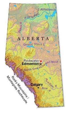
-
Article
Reform Movement in Upper Canada
After the War of 1812, Upper Canada began to develop rapidly. This resulted in social and economic tensions and political issues. These included the expulsion of Robert Gourlay, the Alien Question, the Anglican monopoly of the Clergy Reserves and education, and Tory control of patronage.
"https://d2ttikhf7xbzbs.cloudfront.net/media/media/9e9e3848-d959-4713-9a6f-8747181ebc24.jpg" // resources/views/front/categories/view.blade.php
https://d2ttikhf7xbzbs.cloudfront.net/media/media/9e9e3848-d959-4713-9a6f-8747181ebc24.jpg
-
Article
Regina
Regina, Saskatchewan, founded in 1882, incorporated as a city in 1903, population 226,404 (2021 census), 215,106 (2016 census). The City of Regina is the capital, commercial and financial centre of Saskatchewan. Regina is situated 160 km north of the United States border. The city is set in a wide, level alluvial plain. It was named for Queen Victoria, mother-in-law of the Marquess of Lorne, governor general at the time of the city’s founding.
"https://d2ttikhf7xbzbs.cloudfront.net/media/media/28886a39-49ac-49a7-b464-aeefa4a2b4cc.jpg" // resources/views/front/categories/view.blade.php
https://d2ttikhf7xbzbs.cloudfront.net/media/media/28886a39-49ac-49a7-b464-aeefa4a2b4cc.jpg
-
Article
Music in Regina
Capital city of Saskatchewan. Originally called 'Pile of Bones,' from the Cree word Wascana, it became the capital of the Northwest Territories in 1882 with the coming of the railway and was renamed Regina after Queen Victoria.
"https://development.thecanadianencyclopedia.ca/images/tce_placeholder.jpg?v=e9dca980c9bdb3aa11e832e7ea94f5d9" // resources/views/front/categories/view.blade.php
https://development.thecanadianencyclopedia.ca/images/tce_placeholder.jpg?v=e9dca980c9bdb3aa11e832e7ea94f5d9
-
Article
Reindeer Lake
Reindeer Lake, 6650 km2, elev 337 m, max length 233 km, located on the border between northeastern Saskatchewan and northwestern Manitoba, is the second-largest lake in Saskatchewan and ninth largest in Canada. It has a heavily indented shoreline and contains numerous small islands.
"https://development.thecanadianencyclopedia.ca/images/tce_placeholder.jpg?v=e9dca980c9bdb3aa11e832e7ea94f5d9" // resources/views/front/categories/view.blade.php
https://development.thecanadianencyclopedia.ca/images/tce_placeholder.jpg?v=e9dca980c9bdb3aa11e832e7ea94f5d9