Browse "Places"
-
Article
Reserves on Prince Edward Island
There are four reserves on Prince Edward Island, held by two First Nations (see also First Nations on Prince Edward Island). Three of these reserves, Morell, Rocky Point and Scotchfort, are held by Abegweit First Nation, while Lennox Island is held by Lennox Island First Nation. PEI is just one of two provinces, the other being Nova Scotia, that is part of the traditional territory of only one Indigenous people. In both cases, it is the Mi'kmaq. Of PEI’s 1,405 registered Mi'kmaq (2021), 615 live on the four reserves. The reserves vary in size from less than 1 km 2 to 5.4 km2. Both Lennox Island and Abegweit First Nations are headed by Chiefs, who are required to live on-reserve, and Councillors, who may live on- or off-reserve. Elections are held in a three-year and four-year cycle, respectively.
"https://d2ttikhf7xbzbs.cloudfront.net/media/new_article_images/ReservesonPEI/LennoxIslandChildren.jpg" // resources/views/front/categories/view.blade.php
https://d2ttikhf7xbzbs.cloudfront.net/media/new_article_images/ReservesonPEI/LennoxIslandChildren.jpg
-
search.types.interactivemap
Residential Schools in Canada Interactive Map
The map below indicates the location of many residential schools in Canada. Click on individual points to learn a school’s name, religious denomination, opening and closing dates, and any other names by which the school was known. This map does not reflect every residential school that operated in the country. It only includes schools listed in the Indian Residential School Settlement Agreement and a similar agreement reached for survivors of schools in Newfoundland and Labrador. This means that schools that operated without the support of the federal government — as in schools run by a province, a religious order, or both — are not included on this map. Day schools, where many Indigenous students experienced treatment similar to that described at residential schools, are also not included.
"https://d2ttikhf7xbzbs.cloudfront.net/media/new_article_images/ResidentialSchoolMap/ResidentialSchoolMapScreenGrab.png" // resources/views/front/categories/view.blade.php
https://d2ttikhf7xbzbs.cloudfront.net/media/new_article_images/ResidentialSchoolMap/ResidentialSchoolMapScreenGrab.png
-
Article
Resistance and Residential Schools
Residential schools were government-sponsored religious schools that many Indigenous children were forced to attend. They were established to assimilate Indigenous children into Euro-Canadian culture. Indigenous parents and children did not simply accept the residential-school system. Indigenous peoples fought against – and engaged with – the state, schools and other key players in the system. For the duration of the residential-school era, parents acted in the best interests of their children and communities. The children responded in ways that would allow them to survive.
"https://d2ttikhf7xbzbs.cloudfront.net/ResistanceandResidentialSchools/a101771-v8.jpg" // resources/views/front/categories/view.blade.php
https://d2ttikhf7xbzbs.cloudfront.net/ResistanceandResidentialSchools/a101771-v8.jpg
-
Article
Resolute
Resolute, Nunavut, incorporated as a hamlet in 1987, population 198 (2021 census), 183 (2016 census). The Hamlet of Resolute is located on the south coast of Cornwallis Island in the Arctic Archipelago, near the middle of the Northwest Passage. It is the second most northern community in both Nunavut and Canada and is far enough North that the sun never sets in the winter.
"https://d2ttikhf7xbzbs.cloudfront.net/resolute/Resolute.jpg" // resources/views/front/categories/view.blade.php
https://d2ttikhf7xbzbs.cloudfront.net/resolute/Resolute.jpg
-
Article
Restigouche River
Restigouche River (Ristigouche in Québec), 200 km long, rises in the highlands of northwestern New Brunswick as the Little Main Restigouche River.
"https://development.thecanadianencyclopedia.ca/images/tce_placeholder.jpg?v=e9dca980c9bdb3aa11e832e7ea94f5d9" // resources/views/front/categories/view.blade.php
https://development.thecanadianencyclopedia.ca/images/tce_placeholder.jpg?v=e9dca980c9bdb3aa11e832e7ea94f5d9
-
Article
Revelstoke
Revelstoke, British Columbia, incorporated as a city in 1899, population 7,547 (2016 census), 7,139 (2011 census). The city of Revelstoke is situated on the Columbia River between the Selkirk and Monashee mountains. It is on the Trans-Canada Highway at the western entrance to Rogers Pass and Mount Revelstoke and Glacier national parks. Revelstoke is located on the traditional territory of the Ktunaxa, Sinixt, Secwepemc and Okanagan peoples. (See also Interior Salish.)
"https://d2ttikhf7xbzbs.cloudfront.net/media/media/d1ad52d1-3866-4ccd-9454-4d28fb26ee18.jpg" // resources/views/front/categories/view.blade.php
https://d2ttikhf7xbzbs.cloudfront.net/media/media/d1ad52d1-3866-4ccd-9454-4d28fb26ee18.jpg
-
Macleans
Revelstoke Avalanche Deaths Raise Questions About Backcountry Safety
RICH MARSHALL, back from a therapeutic ski trek with his wife, Abby Watkins, sits at the kitchen table of their home in Golden, B.C., attempting to describe the godawful choices thrust upon them on Feb. 1 by chance, by training and, as they see it, by a duty to help.This article was originally published in Maclean's Magazine on February 17, 2003
"https://development.thecanadianencyclopedia.ca/images/tce_placeholder.jpg?v=e9dca980c9bdb3aa11e832e7ea94f5d9" // resources/views/front/categories/view.blade.php
https://development.thecanadianencyclopedia.ca/images/tce_placeholder.jpg?v=e9dca980c9bdb3aa11e832e7ea94f5d9
-
Article
Rexton
Rexton, NB, incorporated as a village in 1966, population 818 (2011c), 862 (2006c). The Village of Rexton is located in southeastern New Brunswick, at the mouth of the Richibucto River.
"https://development.thecanadianencyclopedia.ca/images/tce_placeholder.jpg?v=e9dca980c9bdb3aa11e832e7ea94f5d9" // resources/views/front/categories/view.blade.php
https://development.thecanadianencyclopedia.ca/images/tce_placeholder.jpg?v=e9dca980c9bdb3aa11e832e7ea94f5d9
-
Article
Richmond
Richmond, British Columbia, incorporated as a city in 1990, population 209,937 (2021 census), 198,309 (2016 census). The City of Richmond is located adjacent to and south of Vancouver and west of New Westminster. The city comprises Sea Island, most of Lulu Island and 12 smaller islands in the delta of the Fraser River. Due to its culturally diverse populace, the city provides many services in different languages. Vancouver International Airport is located in Richmond.
"https://development.thecanadianencyclopedia.ca/images/tce_placeholder.jpg?v=e9dca980c9bdb3aa11e832e7ea94f5d9" // resources/views/front/categories/view.blade.php
https://development.thecanadianencyclopedia.ca/images/tce_placeholder.jpg?v=e9dca980c9bdb3aa11e832e7ea94f5d9
-
Article
Richmond Hill
Richmond Hill, Ontario, is a city 23 km north of Lake Ontario, population 202,022 (2021 census), 195,022 (2016 census). It is one of nine municipalities that make up the Regional Municipality of York. The city is bordered by Aurora to the north, Whitchurch-Stouffville to the east, Markham to the east and south, Vaughan to the west and south, and King Township to the west. Richmond Hill became an incorporated village in 1872, changing status to town in 1957, and city in 2019. The modern borders were established in 1971 from the Town of Richmond Hill, as well as parts of King, Vaughan, Whitchurch and Markham Townships. Throughout history, the Richmond Hill area has been home to different Indigenous groups, namely the Huron Wendat, Haudenosaunee and Anishinaabeg. The land is covered by Treaty 13 and the Williams Treaties.
"https://d2ttikhf7xbzbs.cloudfront.net/media/new_article_images/RichmondHill/DowntownRichmondHill.jpg" // resources/views/front/categories/view.blade.php
https://d2ttikhf7xbzbs.cloudfront.net/media/new_article_images/RichmondHill/DowntownRichmondHill.jpg
-
Article
Rideau Hall
A sophisticated estate that incorporated the primary elements of English landscape style, Rideau Hall was thought to be in keeping with the stature and lifestyle of the Queen's representative in Canada.
"https://d2ttikhf7xbzbs.cloudfront.net/media/media/65601146-87c4-4c0a-9747-e9ea04708cd6.jpg" // resources/views/front/categories/view.blade.php
https://d2ttikhf7xbzbs.cloudfront.net/media/media/65601146-87c4-4c0a-9747-e9ea04708cd6.jpg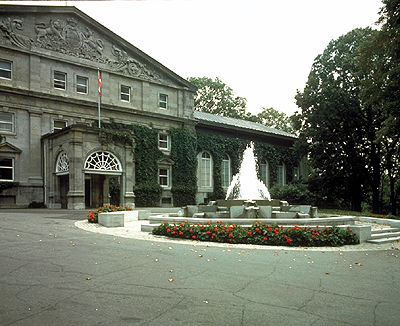
-
Article
Rideau Lakes
Rideau Lakes, 65 km2, elev 123 m, mean depth 12.3 m, is a commonly used collective name for 3 lakes: Big Rideau, Upper Rideau and Lower Rideau.
"https://d2ttikhf7xbzbs.cloudfront.net/media/media/3f6f49a4-9e6a-4764-8ac0-b535a8fed146.jpg" // resources/views/front/categories/view.blade.php
https://d2ttikhf7xbzbs.cloudfront.net/media/media/3f6f49a4-9e6a-4764-8ac0-b535a8fed146.jpg
-
Article
Rideau River
The Rideau River flows 100 km northwards from the Rideau Lakes in eastern Ontario to the Ottawa River at Ottawa.
"https://d2ttikhf7xbzbs.cloudfront.net/media/media/7d8b1603-093b-431d-9c12-aa68e477912f.jpg" // resources/views/front/categories/view.blade.php
https://d2ttikhf7xbzbs.cloudfront.net/media/media/7d8b1603-093b-431d-9c12-aa68e477912f.jpg
-
Article
Riding Mountain National Park
Natural History The park is a rolling landscape of mixed forests and grasslands dotted with lakes, streams and bogs, an "island" of green rising out of a sea of farmland.
"https://d2ttikhf7xbzbs.cloudfront.net/media/media/c9679ffa-5ed0-4a59-995b-e07de3516e05.jpg" // resources/views/front/categories/view.blade.php
https://d2ttikhf7xbzbs.cloudfront.net/media/media/c9679ffa-5ed0-4a59-995b-e07de3516e05.jpg
-
Article
Rimouski
In the 18th century, agriculture and seasonal fishing were the only occupations, but the area experienced some growth when Québec City merchants, including William Price, began to develop the forest resources and built several sawmills.
"https://development.thecanadianencyclopedia.ca/images/tce_placeholder.jpg?v=e9dca980c9bdb3aa11e832e7ea94f5d9" // resources/views/front/categories/view.blade.php
https://development.thecanadianencyclopedia.ca/images/tce_placeholder.jpg?v=e9dca980c9bdb3aa11e832e7ea94f5d9