Browse "Places"
-
Article
Music in Rimouski
City situated on the south shore of the St Lawrence River, 300 kilometres east of Quebec City. The name, meaning 'moose sanctuary,' comes from the Micmac language.
"https://development.thecanadianencyclopedia.ca/images/tce_placeholder.jpg?v=e9dca980c9bdb3aa11e832e7ea94f5d9" // resources/views/front/categories/view.blade.php
https://development.thecanadianencyclopedia.ca/images/tce_placeholder.jpg?v=e9dca980c9bdb3aa11e832e7ea94f5d9
-
Article
Riverboat
The Riverboat. Coffeehouse in Toronto's Yorkville district. Seating about 100 in the narrow basement of a house at 134 Yorkville Ave, it was opened in October 1964 by Bernie Fiedler and became the best-known coffeehouse in Canada.
"https://development.thecanadianencyclopedia.ca/images/tce_placeholder.jpg?v=e9dca980c9bdb3aa11e832e7ea94f5d9" // resources/views/front/categories/view.blade.php
https://development.thecanadianencyclopedia.ca/images/tce_placeholder.jpg?v=e9dca980c9bdb3aa11e832e7ea94f5d9
-
Article
Riverview
Riverview, incorporated as a town in 1973, population 19 128 (2011c), 17 832 (2006c). The Town of Riverview is situated on the Petitcodiac River opposite MONCTON.
"https://development.thecanadianencyclopedia.ca/images/tce_placeholder.jpg?v=e9dca980c9bdb3aa11e832e7ea94f5d9" // resources/views/front/categories/view.blade.php
https://development.thecanadianencyclopedia.ca/images/tce_placeholder.jpg?v=e9dca980c9bdb3aa11e832e7ea94f5d9
-
"https://development.thecanadianencyclopedia.ca/images/tce_placeholder.jpg?v=e9dca980c9bdb3aa11e832e7ea94f5d9" // resources/views/front/categories/view.blade.php
https://development.thecanadianencyclopedia.ca/images/tce_placeholder.jpg?v=e9dca980c9bdb3aa11e832e7ea94f5d9
-
Article
Rivière Chaudière
Rivière Chaudière, 193 km long and with a basin 6690 km2, is located in southern Québec. It is named after the waters that "boil" from its falls or after the numerous glacial erosion kettles (chaudière is French for boiler and also for bucket).
"https://development.thecanadianencyclopedia.ca/images/tce_placeholder.jpg?v=e9dca980c9bdb3aa11e832e7ea94f5d9" // resources/views/front/categories/view.blade.php
https://development.thecanadianencyclopedia.ca/images/tce_placeholder.jpg?v=e9dca980c9bdb3aa11e832e7ea94f5d9
-
Article
Rivière de Rupert
Rivière de Rupert is 763 km long to the head of Lac Témiscamie. It drains Lac Mistassini and then follows a twisted course through a series of lakes and across a flat coastal plain to discharge into southeastern James Bay.
"https://development.thecanadianencyclopedia.ca/images/tce_placeholder.jpg?v=e9dca980c9bdb3aa11e832e7ea94f5d9" // resources/views/front/categories/view.blade.php
https://development.thecanadianencyclopedia.ca/images/tce_placeholder.jpg?v=e9dca980c9bdb3aa11e832e7ea94f5d9
-
Article
Rivière Dumoine
The Dumoine, 129 km long, rises in Lac Dumoine in southwest Québec and flows off the south edge of the Laurentian Highlands through a series of waterfalls, wild rapids and long chutes into the Ottawa River.
"https://development.thecanadianencyclopedia.ca/images/tce_placeholder.jpg?v=e9dca980c9bdb3aa11e832e7ea94f5d9" // resources/views/front/categories/view.blade.php
https://development.thecanadianencyclopedia.ca/images/tce_placeholder.jpg?v=e9dca980c9bdb3aa11e832e7ea94f5d9
-
Article
Rivière Eastmain
The Rivière Eastmain, 756 km long, rises in the central part of Québec on the side of a low drainage divide from which streams flow west to James Bay.
"https://development.thecanadianencyclopedia.ca/images/tce_placeholder.jpg?v=e9dca980c9bdb3aa11e832e7ea94f5d9" // resources/views/front/categories/view.blade.php
https://development.thecanadianencyclopedia.ca/images/tce_placeholder.jpg?v=e9dca980c9bdb3aa11e832e7ea94f5d9
-
Article
Rivière Koksoak
Koksoak, Rivière, 874 km long (to head of Caniapiscau River), final leg of a river system that drains a vast area (133 000 km2) of northern Québec.
"https://development.thecanadianencyclopedia.ca/images/tce_placeholder.jpg?v=e9dca980c9bdb3aa11e832e7ea94f5d9" // resources/views/front/categories/view.blade.php
https://development.thecanadianencyclopedia.ca/images/tce_placeholder.jpg?v=e9dca980c9bdb3aa11e832e7ea94f5d9
-
Article
Rivière Manicouagan
The Rivière Manicouagan, 560 km long, rises in east-central Québec near the Labrador border and flows south through the Réservoir Manicouagan to the St Lawrence River near Baie-Comeau.
"https://d2ttikhf7xbzbs.cloudfront.net/media/media/6be9c93a-1849-439f-b16a-f87c91691760.jpg" // resources/views/front/categories/view.blade.php
https://d2ttikhf7xbzbs.cloudfront.net/media/media/6be9c93a-1849-439f-b16a-f87c91691760.jpg
-
Article
Rivière Moisie
Rivière Moisie, 410 km long, rises in eastern Québec from Lac Opocopa and flows south to the St. Lawrence River. With a drainage basin of 19,200 km2 and a mean discharge of 490 m3/s, it is the river of greatest volume along the middle north Shore of the St. Lawrence.
"https://development.thecanadianencyclopedia.ca/images/tce_placeholder.jpg?v=e9dca980c9bdb3aa11e832e7ea94f5d9" // resources/views/front/categories/view.blade.php
https://development.thecanadianencyclopedia.ca/images/tce_placeholder.jpg?v=e9dca980c9bdb3aa11e832e7ea94f5d9
-
Article
Rivière Nottaway
Rivière Nottaway, 776 km (via Rivière Bell to head of Rivière Mégiscane), rises in west-central Québec and flows north via Lacs Parent and Quévillon into Lac Matagami. Here it is joined by its chief headstream, Rivière Waswanipi, and then drains northwest through Lac Soscumica.
"https://development.thecanadianencyclopedia.ca/images/tce_placeholder.jpg?v=e9dca980c9bdb3aa11e832e7ea94f5d9" // resources/views/front/categories/view.blade.php
https://development.thecanadianencyclopedia.ca/images/tce_placeholder.jpg?v=e9dca980c9bdb3aa11e832e7ea94f5d9
-
Article
Rivière Richelieu
The Richelieu River has played a prominent role in the historical development of Québec. Originally inhabited by Iroquois, Huron and Algonquin, Samuel de CHAMPLAIN navigated its waters shortly after his arrival in 1608.
"https://d2ttikhf7xbzbs.cloudfront.net/media/media/eb8d4d81-eea3-4fe3-b07d-149f6170ebbf.jpg" // resources/views/front/categories/view.blade.php
https://d2ttikhf7xbzbs.cloudfront.net/media/media/eb8d4d81-eea3-4fe3-b07d-149f6170ebbf.jpg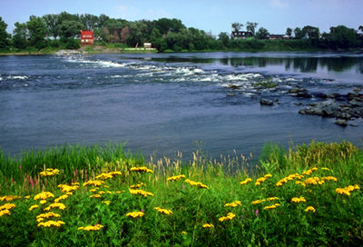
-
Article
Rivière Romaine
Rivière Romaine, 496 km long with a 14 350 km2 basin, rises (elev 760 m) in the Québec-Labrador lacustrine plateau, 45 km southwest of the CHURCHILL RIVER, and forms part of the Québec-Labrador boundary north of the 52nd parallel.
"https://development.thecanadianencyclopedia.ca/images/tce_placeholder.jpg?v=e9dca980c9bdb3aa11e832e7ea94f5d9" // resources/views/front/categories/view.blade.php
https://development.thecanadianencyclopedia.ca/images/tce_placeholder.jpg?v=e9dca980c9bdb3aa11e832e7ea94f5d9
-
Article
Rouge River (Québec)
The Rouge River is a tributary of the Ottawa River. Its source is Lac de la Fougère, in the northeast part of Rouge-Matawin Wildlife Reserve in Québec.
"https://d2ttikhf7xbzbs.cloudfront.net/media/media/6953ea93-69d2-40dd-a80d-f44f0be8c655.JPG" // resources/views/front/categories/view.blade.php
https://d2ttikhf7xbzbs.cloudfront.net/media/media/6953ea93-69d2-40dd-a80d-f44f0be8c655.JPG