Browse "Places"
-
Article
Sillery (Qué)
Sillery has a grand history dating back to the 17th century. It was the site of Canada's first Indian reserve and Jesuit mission, Sillery, on the edge of the St Lawrence. The reserve was funded by Noël Brulart de Sillery (1577-1640), for whom the town was named.
"https://d2ttikhf7xbzbs.cloudfront.net/media/media/91a88fee-54b1-44f5-86a7-a19175816c6e.jpg" // resources/views/front/categories/view.blade.php
https://d2ttikhf7xbzbs.cloudfront.net/media/media/91a88fee-54b1-44f5-86a7-a19175816c6e.jpg
-
Article
Silver Islet
Silver Islet lies off the tip of Sibley Peninsula, across the harbour from Thunder Bay, Ont. In 1868 prospectors found nuggets of pure Silver, and from 1869 to 1884 shafts were sunk deep beneath the rock, which rose only 2.5 m above the water, and $3.2 million in silver was taken.
"https://d2ttikhf7xbzbs.cloudfront.net/media/media/e53f0267-a935-463b-b0cf-e1995d2548ca.jpg" // resources/views/front/categories/view.blade.php
https://d2ttikhf7xbzbs.cloudfront.net/media/media/e53f0267-a935-463b-b0cf-e1995d2548ca.jpg
-
Article
Simcoe
The town of Simcoe, including the nearby hamlet of Hillcrest, was one of 6 area municipalities formed as part of the Regional Municipality of Haldimand-Norfolk in 1974.
"https://development.thecanadianencyclopedia.ca/images/tce_placeholder.jpg?v=e9dca980c9bdb3aa11e832e7ea94f5d9" // resources/views/front/categories/view.blade.php
https://development.thecanadianencyclopedia.ca/images/tce_placeholder.jpg?v=e9dca980c9bdb3aa11e832e7ea94f5d9
-
Article
Sioux Narrows-Nestor Falls
Some 500 Ojibwa currently live on the nearby Whitefish Bay Reserve. European settlement dates from the late 1920s, although previously there were numerous lumber camps in the area.
"https://development.thecanadianencyclopedia.ca/images/tce_placeholder.jpg?v=e9dca980c9bdb3aa11e832e7ea94f5d9" // resources/views/front/categories/view.blade.php
https://development.thecanadianencyclopedia.ca/images/tce_placeholder.jpg?v=e9dca980c9bdb3aa11e832e7ea94f5d9
-
Article
Sirmilik National Park
Located on northern Baffin Island in Canada's High Arctic, Sirmilik National Park (agreement signed 1999; 22 250 km2) is one of Canada's isolated and most spectacular national parks. Sirmilik is an Inuktitut word that means "place of glaciers."
"https://d2ttikhf7xbzbs.cloudfront.net/media/media/99e23c81-75f9-472e-8482-f10ddb1bb260.jpg" // resources/views/front/categories/view.blade.php
https://d2ttikhf7xbzbs.cloudfront.net/media/media/99e23c81-75f9-472e-8482-f10ddb1bb260.jpg
-
Article
Six Nations of the Grand River
Six Nations of the Grand River, Ontario, is the common name for both a reserve and a Haudenosaunee First Nation. The reserve, legally known as Six Nations Indian Reserve No. 40, is just over 182 km2, located along the Grand River in southwestern Ontario. As of September 2024, the nations that make up Six Nations of the Grand River have a combined registered population of 29,209 members, with 12,834 members living on-reserve. Six Nations is the largest First Nations reserve in Canada by population, and the second largest by size. There are several individual communities within the reserve, the largest of which is Ohsweken. (See also Reserves in Ontario.) Six Nations is home to the six individual nations that form the Hodinöhsö:ni’ Confederacy (Haudenosaunee). These nations are the Kanyen’kehaka (Mohawk), Onyota’a:ka (Oneida), Onöñda’gega’ (Onondaga), Gayogohono (Cayuga), Onöndowága’ (Seneca) and Skaru:reh (Tuscarora).
"https://d2ttikhf7xbzbs.cloudfront.net/media/new_article_images/SixNations/SixNationsPowwow.jpg" // resources/views/front/categories/view.blade.php
https://d2ttikhf7xbzbs.cloudfront.net/media/new_article_images/SixNations/SixNationsPowwow.jpg
-
Article
Skeena River
Skeena River, 580 km long, rises in the northern interior of BC and flows generally SW, draining about 54 000 km2, to meet the Pacific Ocean at Chatham Sound south of Prince Rupert.
"https://development.thecanadianencyclopedia.ca/images/tce_placeholder.jpg?v=e9dca980c9bdb3aa11e832e7ea94f5d9" // resources/views/front/categories/view.blade.php
https://development.thecanadianencyclopedia.ca/images/tce_placeholder.jpg?v=e9dca980c9bdb3aa11e832e7ea94f5d9
-
Article
Skinners Pond
Beginning in the 1940s, the fishermen have supplemented their incomes by raking IRISH MOSS from the harbour beaches, from which a gelatinous substance called carrageenin is extracted for use in pharmaceutical and certain food products.
"https://development.thecanadianencyclopedia.ca/images/tce_placeholder.jpg?v=e9dca980c9bdb3aa11e832e7ea94f5d9" // resources/views/front/categories/view.blade.php
https://development.thecanadianencyclopedia.ca/images/tce_placeholder.jpg?v=e9dca980c9bdb3aa11e832e7ea94f5d9
-
Article
Skyscrapers
A skyscraper, simply put, is a building of well-above-average height with useable storeys and a self-supporting skeleton structure. There is no fixed height at which buildings qualify, but those less than about 40 metres (130 feet) or 10 storeys have historically not been considered skyscrapers.
"https://d2ttikhf7xbzbs.cloudfront.net/media/media/ae191658-58e8-4e0b-9a29-ace2229b1b6c.jpg" // resources/views/front/categories/view.blade.php
https://d2ttikhf7xbzbs.cloudfront.net/media/media/ae191658-58e8-4e0b-9a29-ace2229b1b6c.jpg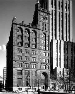
-
Article
Skyscrapers: Table
Skyscrapers: Table Skyscrapers: Table Skyscrapers: Table NAME CITY HEIGHT YEAR First Bank Tower Toronto 298 m/978 ft 1975 Scotia Plaza Toronto 275 m/901 ft 1988 Commerce Court West Toronto 239 m/784 ft 1972 Canada Trust Tower Toronto 226 m/740 ft 1990 Toronto Dominion Bank Tower Toronto 223 m/731 ft 1967 Petro-Canada Centre, West Tower Calgary 210 m/689 ft 1984 Tour du 1000 de la Gauchetière Montréal 204 m/669 ft 1991 Tour IBM-Marathon Montréal 198 m/650...
"https://development.thecanadianencyclopedia.ca/images/tce_placeholder.jpg?v=e9dca980c9bdb3aa11e832e7ea94f5d9" // resources/views/front/categories/view.blade.php
https://development.thecanadianencyclopedia.ca/images/tce_placeholder.jpg?v=e9dca980c9bdb3aa11e832e7ea94f5d9
-
Article
SkyTrain
The SkyTrain is the rapid transit rail system serving Metro Vancouver, British Columbia. It uses mostly Advanced Light Rapid Transit (ALRT) technology, an automated rail system that operates mainly on a raised guideway, although some sections run underground or at street level. Regular service began 3 January 1986. The SkyTrain’s opening coincided with Expo 86, the world’s fair hosted by Vancouver as part of its 100th anniversary celebrations. The system is run by TransLink, the provincial transit agency for the South Coast of British Columbia. It was the world’s first driverless urban rail system. Now, it is one of the longest fully automated rapid transit systems in the world. The SkyTrain has three lines connecting 53 stations in seven municipalities. In 2018, it had more than 495,000 boardings per weekday, on average.
"https://d2ttikhf7xbzbs.cloudfront.net/media/media/82bd1d11-dffa-4919-8590-ae9ea87a523c.jpg" // resources/views/front/categories/view.blade.php
https://d2ttikhf7xbzbs.cloudfront.net/media/media/82bd1d11-dffa-4919-8590-ae9ea87a523c.jpg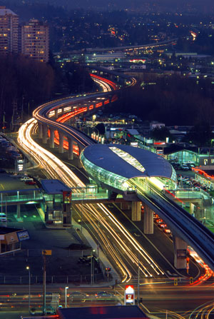
-
Article
Slave Lake
Slave Lake, Alberta, incorporated as a town in 1965, population 6,651 (2016 census), 6,782 (2011 census). The town of Slave Lake is about two kilometres from the southeastern shore of Lesser Slave Lake.
"https://d2ttikhf7xbzbs.cloudfront.net/media/media/04d79109-7d09-494b-943b-1d5a62085ec2.jpg" // resources/views/front/categories/view.blade.php
https://d2ttikhf7xbzbs.cloudfront.net/media/media/04d79109-7d09-494b-943b-1d5a62085ec2.jpg
-
Article
Slave River
Slave River, 415 km long with an estimated mean annual flow rate in excess of 4000 cubic metres per second, connects the PEACE RIVER and the drainage from lakes CLAIRE and ATHABASCA to GREAT SLAVE LAKE, forming the short upper reaches of the Slave- MACKENZIE RIVER system in the Northwest Territories. It has a sinuous, often multichannelled, course traversing the flat, extensively glaciated Archean granitic terrain of the Canadian SHIELD and is currently used almost...
"https://development.thecanadianencyclopedia.ca/images/tce_placeholder.jpg?v=e9dca980c9bdb3aa11e832e7ea94f5d9" // resources/views/front/categories/view.blade.php
https://development.thecanadianencyclopedia.ca/images/tce_placeholder.jpg?v=e9dca980c9bdb3aa11e832e7ea94f5d9
-
Article
Slocan
Slocan, British Columbia, incorporated as a village in 1958, population 272 (2016 census), 296 (2011 census). The village of Slocan is located 70 km by road northwest of Nelson, at the south end of Slocan Lake. Slocan is an Okanagan word meaning “pierce or strike on the head,” referring to the salmon-fishing practice of the Okanagan (see Interior Salish). The community was also known as Slocan City when it was an incorporated city (1901-1958).
"https://d2ttikhf7xbzbs.cloudfront.net/media/media/ade75a0e-66ab-432e-af8e-3566a6dad341.jpg" // resources/views/front/categories/view.blade.php
https://d2ttikhf7xbzbs.cloudfront.net/media/media/ade75a0e-66ab-432e-af8e-3566a6dad341.jpg
-
List
Smallest Cities in Canada
If you look at a map of Canada, the number of place names can be overwhelming. Whether or not these places are considered municipalities depends on legislation specific to the province or territory in which they are located. Depending on the number of people who live there, municipalities may be called a number of names, including city, town, village or hamlet. Most Canadian municipalities have thousands of residents. There are 11, however, that have 10 or fewer people. This list is largely based on Statistics Canada’s 2016 census, as well as reliable information from other sources. It does not include “unorganized” communities, “designated places,” or reserves, as these are governed by larger municipalities, or in the case of reserves, the federal government.
"https://development.thecanadianencyclopedia.ca/images/tce_placeholder.jpg?v=e9dca980c9bdb3aa11e832e7ea94f5d9" // resources/views/front/categories/view.blade.php
https://development.thecanadianencyclopedia.ca/images/tce_placeholder.jpg?v=e9dca980c9bdb3aa11e832e7ea94f5d9