Browse "Places"
-
Article
Burlington
Burlington, Ontario, population 186,948 (2021 census), 183,314 (2016 census), is located at the head of Lake Ontario. It borders Hamilton, Milton and Oakville. Burlington was first incorporated in 1873 as a village, as a town in 1915, and as a city in 1974. Amalgamation created the modern boundaries in 1958, combining the Town of Burlington, Nelson Township, and part of East Flamborough Township. Throughout history, the Burlington area has been home to different Indigenous groups, namely the Neutral, Haudenosaunee and Anishinaabeg, including the Mississauga. The land is covered by treaties 3, 8, 14 and 19 (see Upper Canada Land Surrenders).
"https://d2ttikhf7xbzbs.cloudfront.net/media/media/36ed4822-e26d-4d96-9391-164cab4d1da0.jpg" // resources/views/front/categories/view.blade.php
https://d2ttikhf7xbzbs.cloudfront.net/media/media/36ed4822-e26d-4d96-9391-164cab4d1da0.jpg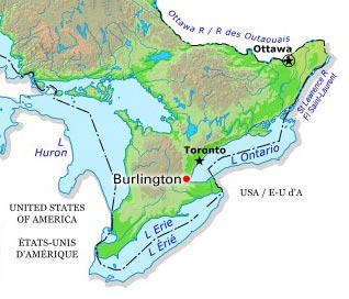
-
Article
Burnaby
Burnaby, BC, incorporated as a city in 1992, population 249,125 (2021 census), 232,755 (2016 census). Burnaby adjoins Vancouver on the west, Coquitlam on the east and New Westminster on the southeast. Named after Robert Burnaby, a businessman and legislator of the 1860s, it features Burnaby Mountain (365 m), Burnaby Lake, the Fraser River and Burrard Inlet. Burnaby was a district municipality for one hundred years before being granted civic status in 1992. It is governed by a mayor and eight councillors and is a member Metro Vancouver. (See also Municipal Government in Canada.)
"https://d2ttikhf7xbzbs.cloudfront.net/media/media/2bd7362f-7692-4d30-b07f-0cde82e5492a.jpg" // resources/views/front/categories/view.blade.php
https://d2ttikhf7xbzbs.cloudfront.net/media/media/2bd7362f-7692-4d30-b07f-0cde82e5492a.jpg
-
Article
Burns Lake
Burns Lake, BC, incorporated as a village in 1923, population 2029 (2011c), 2107 (2006c). The Village of Burns Lake is located on Highway 16 in the geographical centre of British Columbia on the Nechako Plateau, 226 km west of Prince George.
"https://development.thecanadianencyclopedia.ca/images/tce_placeholder.jpg?v=e9dca980c9bdb3aa11e832e7ea94f5d9" // resources/views/front/categories/view.blade.php
https://development.thecanadianencyclopedia.ca/images/tce_placeholder.jpg?v=e9dca980c9bdb3aa11e832e7ea94f5d9
-
Article
Burwash Landing
Burwash Landing,Yukon, settlement, population 72 (2016census), 95 (2011 census). The settlement of Burwash Landing is located on the northwest shore of Kluane Lake at Mile 1095 of theAlaska Highway.
"https://development.thecanadianencyclopedia.ca/images/tce_placeholder.jpg?v=e9dca980c9bdb3aa11e832e7ea94f5d9" // resources/views/front/categories/view.blade.php
https://development.thecanadianencyclopedia.ca/images/tce_placeholder.jpg?v=e9dca980c9bdb3aa11e832e7ea94f5d9
-
Article
Bus Transportation
The word "bus," short for omnibus, refers to any self-propelled road vehicle capable of carrying more persons than a private automobile.
"https://development.thecanadianencyclopedia.ca/images/tce_placeholder.jpg?v=e9dca980c9bdb3aa11e832e7ea94f5d9" // resources/views/front/categories/view.blade.php
https://development.thecanadianencyclopedia.ca/images/tce_placeholder.jpg?v=e9dca980c9bdb3aa11e832e7ea94f5d9
-
Article
Butter Pot Provincial Park
Located on the Avalon Peninsula, Butter Pot Provincial Park (established 1958, 2833 ha) is 36 km southwest of St John's, Newfoundland, along the Trans-Canada Highway.
"https://development.thecanadianencyclopedia.ca/images/tce_placeholder.jpg?v=e9dca980c9bdb3aa11e832e7ea94f5d9" // resources/views/front/categories/view.blade.php
https://development.thecanadianencyclopedia.ca/images/tce_placeholder.jpg?v=e9dca980c9bdb3aa11e832e7ea94f5d9
-
Article
Bylot Island
Bylot Island, 11 067 km2, is nestled into the northeastern corner of Baffin Island at the entrance to Lancaster Sound.
"https://development.thecanadianencyclopedia.ca/images/tce_placeholder.jpg?v=e9dca980c9bdb3aa11e832e7ea94f5d9" // resources/views/front/categories/view.blade.php
https://development.thecanadianencyclopedia.ca/images/tce_placeholder.jpg?v=e9dca980c9bdb3aa11e832e7ea94f5d9
-
Article
Cabbagetown
Cabbagetown, a district in east-central Toronto, the general boundaries of which are the Don River on the east, Parliament St on the west, Gerrard St on the north, and Queen St on the south.
"https://development.thecanadianencyclopedia.ca/images/tce_placeholder.jpg?v=e9dca980c9bdb3aa11e832e7ea94f5d9" // resources/views/front/categories/view.blade.php
https://development.thecanadianencyclopedia.ca/images/tce_placeholder.jpg?v=e9dca980c9bdb3aa11e832e7ea94f5d9
-
Article
Cabot Strait
Cabot Strait, the passage between southwest Newfoundland and Cape Breton Island. Named for explorer John Cabot, it is 110 km wide between Cape Ray, Nfld, and Cape North, NS.
"https://development.thecanadianencyclopedia.ca/images/tce_placeholder.jpg?v=e9dca980c9bdb3aa11e832e7ea94f5d9" // resources/views/front/categories/view.blade.php
https://development.thecanadianencyclopedia.ca/images/tce_placeholder.jpg?v=e9dca980c9bdb3aa11e832e7ea94f5d9
-
Article
Cache Creek
Cache Creek, BC, incorporated as a village in 1967, population 1040 (2011c), 1056 (2001c). The Village of Cache Creek is located in the dry belt of the southern interior of British Columbia at the junction of highways 1 and 97, 84 km west of KAMLOOPS.
"https://development.thecanadianencyclopedia.ca/images/tce_placeholder.jpg?v=e9dca980c9bdb3aa11e832e7ea94f5d9" // resources/views/front/categories/view.blade.php
https://development.thecanadianencyclopedia.ca/images/tce_placeholder.jpg?v=e9dca980c9bdb3aa11e832e7ea94f5d9
-
Article
Café Le Hibou
Café Le Hibou Coffee House was a renowned coffee house in Ottawa. Founded by Denis Faulkner, who ran it until 1968, it was in business from 1960 to 1975. It was an important venue for the folk music scene of the early 1960s. The café helped establish the ByWard Market as Ottawa’s trendy neighbourhood at a time when the city’s nightlife was virtually nonexistent. By the end of the 1960s, it was a frequent stop for big-name artists, musicians and celebrities. It entrenched café culture in Ottawa and helped major venues establish themselves nearby.
"https://development.thecanadianencyclopedia.ca/images/tce_placeholder.jpg?v=e9dca980c9bdb3aa11e832e7ea94f5d9" // resources/views/front/categories/view.blade.php
https://development.thecanadianencyclopedia.ca/images/tce_placeholder.jpg?v=e9dca980c9bdb3aa11e832e7ea94f5d9
-
Article
Caledon
Caledon, Ontario, incorporated as a city in 1974, population 76,581 (2021 census), 66,502 (2016 census). Northwest of Toronto, Caledon shares its border with nine other municipalities. Together with Brampton and Mississauga, it creates the Region of Peel. Up until recent decades, the area has been relatively rural. Today, however, it is in the midst of urbanization. Throughout history, the Caledon area has been home to different Indigenous groups, namely the Wendat (Huron), Tionontati (Petun), Haudenosaunee and Anishinaabeg, including the Mississaugas of the Credit First Nation. The land is part of the Ajetance Purchase (1818).
"https://d2ttikhf7xbzbs.cloudfront.net/Caledon/CaledonBadlands.jpg" // resources/views/front/categories/view.blade.php
https://d2ttikhf7xbzbs.cloudfront.net/Caledon/CaledonBadlands.jpg
-
Article
Calgary
Calgary, Alberta, incorporated as a city in 1894, population 1,306,784 (2021 census), 1,239,220 (2016 census). The city of Calgary is situated on the Bow River in southern Alberta, about 220 km north of the American border at the meeting point of the Western prairies and mountain foothills. It is the financial centre of western Canada, based on its key role in the development of the region’s oil and gas industry. With its panoramic backdrop of the Rocky Mountains and its historic association with cattle ranching and oil exploration, Calgary is one of Canada’s most identifiable cities.
"https://d2ttikhf7xbzbs.cloudfront.net/media/media/82e124db-7884-44c8-85c5-5696968ef38e.jpg" // resources/views/front/categories/view.blade.php
https://d2ttikhf7xbzbs.cloudfront.net/media/media/82e124db-7884-44c8-85c5-5696968ef38e.jpg
-
Article
Music in Calgary
Alberta city founded on or near the site of Fort la Jonquière which was built in 1751 at the junction of the Bow and Elbow rivers and was abandoned after 1785. Fort Brisebois, established there by the Northwest Mounted Police in 1875, was renamed Fort Calgary a year later.
"https://development.thecanadianencyclopedia.ca/images/tce_placeholder.jpg?v=e9dca980c9bdb3aa11e832e7ea94f5d9" // resources/views/front/categories/view.blade.php
https://development.thecanadianencyclopedia.ca/images/tce_placeholder.jpg?v=e9dca980c9bdb3aa11e832e7ea94f5d9
-
Article
Cambridge
Cambridge, Ontario, incorporated as a city in 1973, population 138,479 (2021 census), 129,920 (2016 census). Cambridge is located within Waterloo Region and along the Grand River. It was created through the amalgamation of the City of Galt, the Towns of Preston and Hespeler, and parts of North Dumfries and Waterloo townships. Throughout history, the Cambridge area has been home to different Indigenous groups, namely the Neutral, Haudenosaunee and Anishinaabe. The land is covered by the Haldimand Proclamation.
"https://d2ttikhf7xbzbs.cloudfront.net/Cambridge/GrandRiverCambridge.jpg" // resources/views/front/categories/view.blade.php
https://d2ttikhf7xbzbs.cloudfront.net/Cambridge/GrandRiverCambridge.jpg