Browse "Places"
-
Article
Coronation Gulf
Coronation Gulf is a broad indentation in the arctic shore of the territory of Nunavut, roughly the shape of the south coast of Victoria Island, which lies directly north.
"https://d2ttikhf7xbzbs.cloudfront.net/media/media/b504d03a-1419-4bf4-ab27-00b5e8cc89a0.jpg" // resources/views/front/categories/view.blade.php
https://d2ttikhf7xbzbs.cloudfront.net/media/media/b504d03a-1419-4bf4-ab27-00b5e8cc89a0.jpg
-
Article
Côte-des-Neiges
Côte-des-Neiges is a Montreal neighbourhood located on the ancestral lands of several Indigenous peoples. Situated on the western slope of Mount Royal, it is part of the borough of Côte-des-Neiges—Notre-Dame-de-Grâce. Côte-des-Neiges is known for its ethnocultural diversity, due to the numerous cohorts of immigration that have settled there. (See Immigration to Canada.) According to the 2016 census, the neighbourhood has a population of 99,540. Of this number, over 54 per cent belong to racialized groups; approximately 52 per cent are immigrants; 45 per cent are allophones. Côte-des-Neiges is also home to a number of major institutions, such as the Université de Montréal and Saint Joseph’s Oratory.
"https://d2ttikhf7xbzbs.cloudfront.net/media/media/VM94-A0639-001.jpg" // resources/views/front/categories/view.blade.php
https://d2ttikhf7xbzbs.cloudfront.net/media/media/VM94-A0639-001.jpg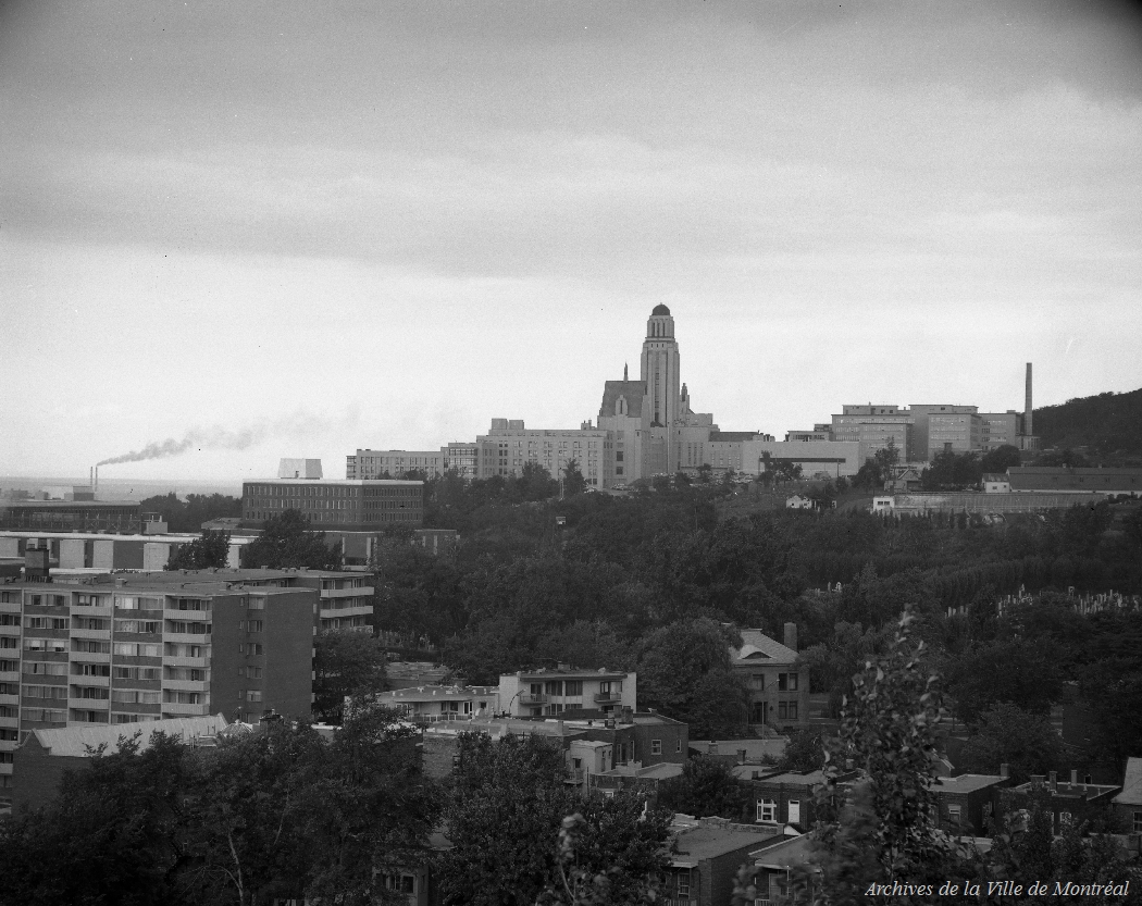
-
Article
Côte-Saint-Luc
Côte-Saint-Luc, originally settled in the 18th century, remained a farming community until the middle of the 20th century. In 1818, the total population of the community was 209; in 1940 it had only reached 747.
"https://development.thecanadianencyclopedia.ca/images/tce_placeholder.jpg?v=e9dca980c9bdb3aa11e832e7ea94f5d9" // resources/views/front/categories/view.blade.php
https://development.thecanadianencyclopedia.ca/images/tce_placeholder.jpg?v=e9dca980c9bdb3aa11e832e7ea94f5d9
-
Article
Courtenay
Courtenay, BC, incorporated as a city, population 24 099 (2011c), 21 940 (2006c). The City of Courtenay is located on the east coast of Vancouver Island, 220 km by road north of Victoria. The city is situated on a narrow plain, with mountains to the west rising over 2000 m.
"https://development.thecanadianencyclopedia.ca/images/tce_placeholder.jpg?v=e9dca980c9bdb3aa11e832e7ea94f5d9" // resources/views/front/categories/view.blade.php
https://development.thecanadianencyclopedia.ca/images/tce_placeholder.jpg?v=e9dca980c9bdb3aa11e832e7ea94f5d9
-
Article
Cowansville
Cowansville was an agricultural, textile and furniture-making centre until 1940, when it underwent industrial diversification. Situated about 20 km from the US border and 85 km southeast of MONTRÉAL, it has attracted several large companies based in the northern United States and Ontario.
"https://development.thecanadianencyclopedia.ca/images/tce_placeholder.jpg?v=e9dca980c9bdb3aa11e832e7ea94f5d9" // resources/views/front/categories/view.blade.php
https://development.thecanadianencyclopedia.ca/images/tce_placeholder.jpg?v=e9dca980c9bdb3aa11e832e7ea94f5d9
-
Article
Craigellachie
Craigellachie, BC, is a small community located at the west entrance to Eagle Pass. Craigellachie was the place where Donald Smith drove the symbolic "last spike" in a ceremony marking the completion of the Canadian Pacific Railway.
"https://d2ttikhf7xbzbs.cloudfront.net/media/media/62923069-c687-482d-b465-8d1c007b323c.jpg" // resources/views/front/categories/view.blade.php
https://d2ttikhf7xbzbs.cloudfront.net/media/media/62923069-c687-482d-b465-8d1c007b323c.jpg
-
Article
Craigflower Manor and Schoolhouse
The Craigflower Manor (1856) and Schoolhouse (1855) were built by the Puget's Sound Agricultural Company, a subsidiary of the Hudson’s Bay Company (HBC). Both the manor and schoolhouse national historic sites located near Victoria, British Columbia.
"https://d2ttikhf7xbzbs.cloudfront.net/Craigflower/Craigflower_Manor_House.jpg" // resources/views/front/categories/view.blade.php
https://d2ttikhf7xbzbs.cloudfront.net/Craigflower/Craigflower_Manor_House.jpg
-
Article
Cranbrook
Cranbrook, BC, incorporated as a city in 1905, population 19 319 (2011c), 18 329 (2006c). The City of Cranbrook lies near the western edge of the ROCKY MOUNTAIN TRENCH, in the Kootenay region, 845 km east of Vancouver.
"https://development.thecanadianencyclopedia.ca/images/tce_placeholder.jpg?v=e9dca980c9bdb3aa11e832e7ea94f5d9" // resources/views/front/categories/view.blade.php
https://development.thecanadianencyclopedia.ca/images/tce_placeholder.jpg?v=e9dca980c9bdb3aa11e832e7ea94f5d9
-
Article
Crawford Lake (Kionywarihwaen)
Crawford Lake is a small, deep body of water in central Milton, Southern Ontario. The lake is located in a conservation area within the Halton Region and is part of the Niagara Escarpment. The lake’s name derives from the Crawford family, who lived on the site prior to it being bought by the conservation authority. Its Wendat place name, “Kionywarihwaen,” also reflects its history as an Indigenous settlement. For decades, the lake has been the site of various scientific studies.
"https://d2ttikhf7xbzbs.cloudfront.net/crawfordlake/Crawford-Lake.jpg" // resources/views/front/categories/view.blade.php
https://d2ttikhf7xbzbs.cloudfront.net/crawfordlake/Crawford-Lake.jpg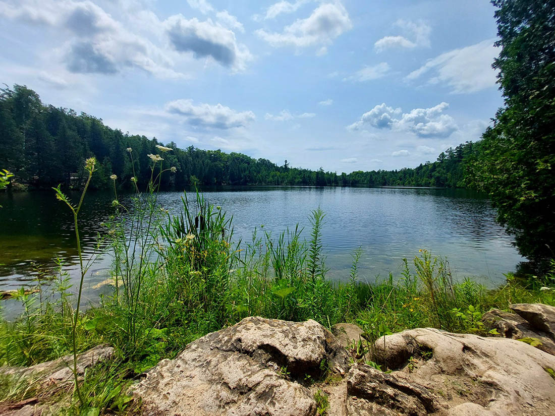
-
Article
Cree Lake
Cree Lake, 1435 km2, elevation 487 m, max length 81 km, max width 57 km, located in northern Saskatchewan west of Reindeer Lake and S of Lake Athabasca, is the fourth-largest lake in Saskatchewan.
"https://development.thecanadianencyclopedia.ca/images/tce_placeholder.jpg?v=e9dca980c9bdb3aa11e832e7ea94f5d9" // resources/views/front/categories/view.blade.php
https://development.thecanadianencyclopedia.ca/images/tce_placeholder.jpg?v=e9dca980c9bdb3aa11e832e7ea94f5d9
-
Article
Creighton
The town of Creighton dates from the 1930s when the Department of Natural Resources constructed a road from Flin Flon to Amisk Lake. People began to settle along the road, and after World War II a town site was surveyed. The lots were largely taken up by young men returning from the armed services.
"https://d2ttikhf7xbzbs.cloudfront.net/media/media/d327e8c0-7182-4be6-8d02-fa173c58bd79.jpg" // resources/views/front/categories/view.blade.php
https://d2ttikhf7xbzbs.cloudfront.net/media/media/d327e8c0-7182-4be6-8d02-fa173c58bd79.jpg
-
Article
Creston
Creston, BC, incorporated as a town in 1924, population 5306 (2011c), 4826 (2006c). The Town of Creston is located in the west Kootenay region of southeastern British Columbia.
"https://development.thecanadianencyclopedia.ca/images/tce_placeholder.jpg?v=e9dca980c9bdb3aa11e832e7ea94f5d9" // resources/views/front/categories/view.blade.php
https://development.thecanadianencyclopedia.ca/images/tce_placeholder.jpg?v=e9dca980c9bdb3aa11e832e7ea94f5d9
-
Article
Crown Point
Crown Point is a large peninsula strategically commanding the narrow passage of the southwestern portion of Lake CHAMPLAIN in upper New York State. It was initially the site of Fort Saint-Frédéric, built by the French in 1731 to defend French territory from English colonial invasion.
"https://development.thecanadianencyclopedia.ca/images/tce_placeholder.jpg?v=e9dca980c9bdb3aa11e832e7ea94f5d9" // resources/views/front/categories/view.blade.php
https://development.thecanadianencyclopedia.ca/images/tce_placeholder.jpg?v=e9dca980c9bdb3aa11e832e7ea94f5d9
-
Article
Crowsnest Pass
Crowsnest Pass, elevation 1357 m, is situated in the Rocky Mountains, on the BC-Alberta border.
"https://development.thecanadianencyclopedia.ca/images/tce_placeholder.jpg?v=e9dca980c9bdb3aa11e832e7ea94f5d9" // resources/views/front/categories/view.blade.php
https://development.thecanadianencyclopedia.ca/images/tce_placeholder.jpg?v=e9dca980c9bdb3aa11e832e7ea94f5d9
-
Article
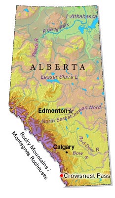
Crowsnest Pass (Alta)
Crowsnest Pass, Alta, incorporated as a municipality in 2008, population 5565 (2011c), 6261 (2006c). The Municipality of Crowsnest Pass is located 269 km southwest of Calgary in the historic CROWSNEST PASS through the Rocky Mountains. The municipality takes its name from a prominent nearby mountain.
"https://d2ttikhf7xbzbs.cloudfront.net/media/media/a9ba436e-b7bf-4c60-be8f-304e450dbf4f.jpg" // resources/views/front/categories/view.blade.php
https://d2ttikhf7xbzbs.cloudfront.net/media/media/a9ba436e-b7bf-4c60-be8f-304e450dbf4f.jpg