Browse "Places"
-
Article
Kirkland
The town began with an edict by King Louis the XIV of France on 29 June 1711 which established the parish of St-Joachim de Pointe-Claire. A civil parish was established 11 years later on 3 March 1722. On 1 July 1845, the parish came under the control of the clergy.
"https://d2ttikhf7xbzbs.cloudfront.net/media/media/957abd37-5418-464b-9c53-740d485debeb.jpg" // resources/views/front/categories/view.blade.php
https://d2ttikhf7xbzbs.cloudfront.net/media/media/957abd37-5418-464b-9c53-740d485debeb.jpg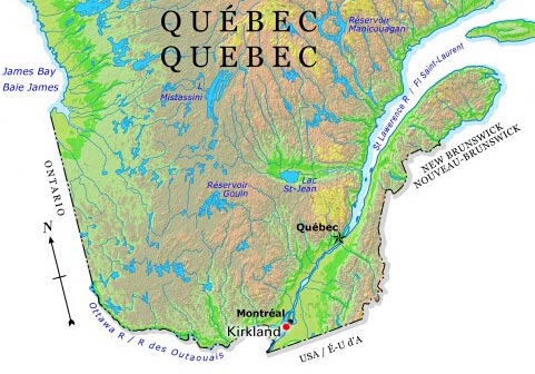
-
Article
Kirkland Lake
Kirkland Lake, Ont, incorporated as a town in 1972, population 8133 (2011c), 8248 (2006c). The Town of Kirkland Lake is located 241 km northwest of North Bay.
"https://development.thecanadianencyclopedia.ca/images/tce_placeholder.jpg?v=e9dca980c9bdb3aa11e832e7ea94f5d9" // resources/views/front/categories/view.blade.php
https://development.thecanadianencyclopedia.ca/images/tce_placeholder.jpg?v=e9dca980c9bdb3aa11e832e7ea94f5d9
-
Article
Music in Kitchener-Waterloo
Twin cities in southwestern Ontario. In both, a significant proportion of the population has always been of German and Mennonite stock. Kitchener, the larger of the two cities, was called Ebytown until 1824 and Berlin until 1916.
"https://development.thecanadianencyclopedia.ca/images/tce_placeholder.jpg?v=e9dca980c9bdb3aa11e832e7ea94f5d9" // resources/views/front/categories/view.blade.php
https://development.thecanadianencyclopedia.ca/images/tce_placeholder.jpg?v=e9dca980c9bdb3aa11e832e7ea94f5d9
-
Article
Kitchener-Waterloo
Kitchener, Ontario, incorporated as a city in 1912, population 256,885 (2021 census), 233,222 (2016 census). Waterloo, Ontario, incorporated as a city in 1948, population 121,436 (2021 census), 104,986 (2016 census). The twin cities of Kitchener-Waterloo are located in central southwestern Ontario, 105 km southwest of Toronto. Each retains its own political culture within a common historical framework and with similar, but by no means identical, socio-economic developments. Kitchener (originally named Berlin), the larger of the two, was the county seat (1853), judicial and financial centre of Waterloo County from 1853 to 1973. It continues to have a predominant influence in the Regional Municipality of Waterloo, which was formed in 1973 by combining several communities and cities, including Kitchener, Waterloo and Cambridge.
"https://d2ttikhf7xbzbs.cloudfront.net/media/media/936bad19-168e-4c98-a747-201f5eb2cefa.jpg" // resources/views/front/categories/view.blade.php
https://d2ttikhf7xbzbs.cloudfront.net/media/media/936bad19-168e-4c98-a747-201f5eb2cefa.jpg
-
Article
Kitigaaryuit (Kittigazuit)
Kitigaaryuit is the name of an area (ca 5 km2) at the mouth of the East Channel of the Mackenzie River that was the gathering place of the Kitigaaryungmiut.
"https://d2ttikhf7xbzbs.cloudfront.net/media/media/edd62de2-9eff-48e0-978d-f634c3dc4dc8.jpg" // resources/views/front/categories/view.blade.php
https://d2ttikhf7xbzbs.cloudfront.net/media/media/edd62de2-9eff-48e0-978d-f634c3dc4dc8.jpg
-
Article
Kitimat
Kitimat, British Columbia, incorporated as a district municipality in 1953, population 8,236 (2021 census), 8,131 (2016 census). The district of Kitimat is located at the head of the Douglas Channel, 206 km east of Prince Rupert by road. Its name comes from the Tsimshian term for the Haisla inhabitants of the area, Kitamaat (“people of the snow”). The modern community was founded in the early 1950s.
"https://d2ttikhf7xbzbs.cloudfront.net/media/new_article_images/Kitimat/Kitimat_2008.jpg" // resources/views/front/categories/view.blade.php
https://d2ttikhf7xbzbs.cloudfront.net/media/new_article_images/Kitimat/Kitimat_2008.jpg
-
Article
Kitsilano
Kitsilano, a 549 ha waterfront section of VANCOUVER, incorporated into that city in 1886. It stretches south from English Bay to 16th Avenue and east from Alma to Burrard street.
"https://d2ttikhf7xbzbs.cloudfront.net/media/media/a1d97bef-a8f5-4fa4-89fe-aadf1c0107f6.jpg" // resources/views/front/categories/view.blade.php
https://d2ttikhf7xbzbs.cloudfront.net/media/media/a1d97bef-a8f5-4fa4-89fe-aadf1c0107f6.jpg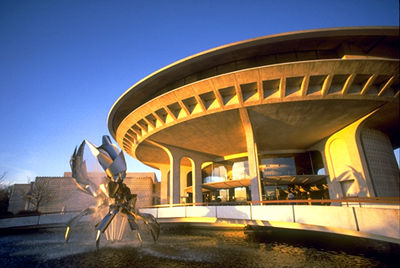
-
Article
Gitwangak Battle Hill National Historic Site
Gitwangak Battle Hill (formerly Kitwanga Fort) is the site of a former Gitwangak fortified village on the Kitwanga River in British Columbia, northeast of Terrace.
"https://d2ttikhf7xbzbs.cloudfront.net/media/media/fa957cb9-e291-44d5-aac2-e406ec5ea9d1.JPG" // resources/views/front/categories/view.blade.php
https://d2ttikhf7xbzbs.cloudfront.net/media/media/fa957cb9-e291-44d5-aac2-e406ec5ea9d1.JPG
-
Article
Kleinburg
Kleinburg, Ont, straddles a hogback between 2 branches of the Humber River 40 km NW of Toronto. It has no legal entity, being part of the sprawling city of Vaughan (formerly Vaughan Township), and therefore no official boundaries. Founded around 1847 by an Alsatian immigrant, John Kline (sic), who built the first gristmill, it is known today as the site of one of Canada's largest art galleries, the McMichael Canadian Art Collection; for the Toronto...
"https://development.thecanadianencyclopedia.ca/images/tce_placeholder.jpg?v=e9dca980c9bdb3aa11e832e7ea94f5d9" // resources/views/front/categories/view.blade.php
https://development.thecanadianencyclopedia.ca/images/tce_placeholder.jpg?v=e9dca980c9bdb3aa11e832e7ea94f5d9
-
Article
Klondike
Klondike (also spelled Klondyke). The name is derived from a Gwich'in word, thron-duick (hammer river), and identifies a town, a river, and a range of hills in the Yukon.
"https://development.thecanadianencyclopedia.ca/images/tce_placeholder.jpg?v=e9dca980c9bdb3aa11e832e7ea94f5d9" // resources/views/front/categories/view.blade.php
https://development.thecanadianencyclopedia.ca/images/tce_placeholder.jpg?v=e9dca980c9bdb3aa11e832e7ea94f5d9
-
Article
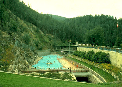
Kluane National Park and Reserve
Kluane National Park and Reserve (established 1976, 21,980 km2) is an area of unclimbed peaks, vast ice fields, clear lakes, glaciers and spectacular wildlife. Tucked in the southwest corner of the Yukon Territory, 150 km west of Whitehorse, Kluane (pronounced kloo-AH-nee) contains Canada’s highest peak, Mount Logan. It is named after Yukon’s largest lake, which borders the park. The park and park reserve, together with Tatshenshini-Alsek Wilderness Provincial Park in British Columbia and Glacier Bay and Wrangell-St. Elias national parks in Alaska, form an international UNESCO World Heritage Site covering over 98,391 km2.
"https://d2ttikhf7xbzbs.cloudfront.net/media/media/eaf72296-f152-4658-8249-bbf7a8b70296.jpg" // resources/views/front/categories/view.blade.php
https://d2ttikhf7xbzbs.cloudfront.net/media/media/eaf72296-f152-4658-8249-bbf7a8b70296.jpg
-
Article
Kluane Ranges
The Kluane Ranges are a chain of mountains in the Yukon that run parallel to Haines Road and the Alaska Highway. The Kluane Ranges extend 350 km northwest from the easternmost St. Elias Mountains in the Yukon to the Tatshenshini River just beyond the Yukon-Alaska boundary.
"https://d2ttikhf7xbzbs.cloudfront.net/kluaneranges/Spruce-Forest.jpg" // resources/views/front/categories/view.blade.php
https://d2ttikhf7xbzbs.cloudfront.net/kluaneranges/Spruce-Forest.jpg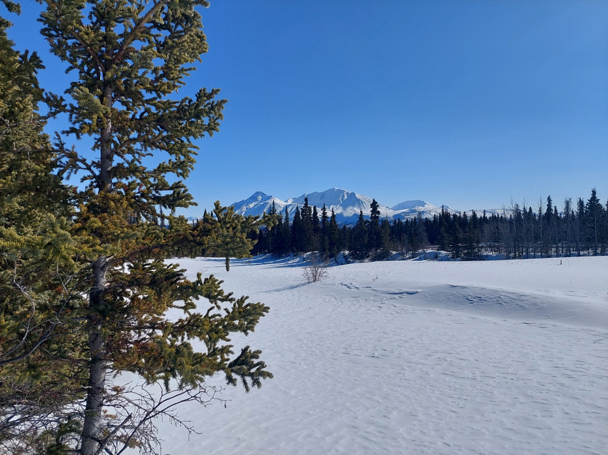
-
Article
Koerner Hall
Koerner Hall, which seats 1,135 and took about 3 years to build at an approximate cost of $110 million, actually dates back to 1991.
"https://d2ttikhf7xbzbs.cloudfront.net/media/media/05cd04a8-bf63-4691-8b60-aa6e50fb8965.jpg" // resources/views/front/categories/view.blade.php
https://d2ttikhf7xbzbs.cloudfront.net/media/media/05cd04a8-bf63-4691-8b60-aa6e50fb8965.jpg
-
Article
Kootenay Lake
Kootenay Lake, 407 km2, elev 532 m, is situated in the mountainous southeastern interior of BC.
"https://d2ttikhf7xbzbs.cloudfront.net/media/media/889433fb-787d-4d50-9c0d-a3cfcfcff6a5.jpg" // resources/views/front/categories/view.blade.php
https://d2ttikhf7xbzbs.cloudfront.net/media/media/889433fb-787d-4d50-9c0d-a3cfcfcff6a5.jpg
-
Article
Kootenay National Park
Kootenay National Park (established 1920, 1406.4 km2) is located on the west slope of the Continental Divide. The park, stretching north and south for 104 km, is bounded on the east by Banff and Mount Assiniboine Provincial Park on the north by Yoho National Park.
"https://d2ttikhf7xbzbs.cloudfront.net/media/media/1aa8fafc-a0a0-48c9-86a8-6e588b13ecfe.jpg" // resources/views/front/categories/view.blade.php
https://d2ttikhf7xbzbs.cloudfront.net/media/media/1aa8fafc-a0a0-48c9-86a8-6e588b13ecfe.jpg