Places | The Canadian Encyclopedia

Browse "Places"

Displaying 1726-1740 of 2286 results
  • Article

    Saint Joseph's Oratory

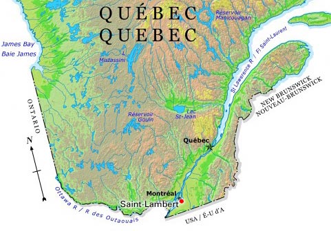
    Saint Joseph’s Oratory of Mount Royal is a minor basilica of the Roman Catholic Church. The Oratory is located on the northwestern slope of Mount Royal in the city of Montreal. (See also Côte-des-Neiges.) It is the tallest church in Canada and one of the largest domed structures in the world. The Oratory is an important landmark and symbol of Montreal, as well as a tourist attraction. Pilgrims come to visit it from all corners of the world. It attracts about 2 million visitors every year.

    "https://d2ttikhf7xbzbs.cloudfront.net/media/media/Oratoire-saint-joseph.jpg" // resources/views/front/categories/view.blade.php
    
    https://d2ttikhf7xbzbs.cloudfront.net/media/media/Oratoire-saint-joseph.jpg Saint Joseph's Oratory
  • Article

    Saint-Lambert

    Saint-Lambert, Quebec, population 21,861 (2016 census), 21,555 (2011 census). Saint-Lambert was settled beginning in the 17th century. It was first incorporated as a city in 1921 and reincorporated in 2006. Saint-Lambert was amalgamated into the city of Longueuil from 2002 until 2006 when it regained its municipal status. It is located along the South Shore of the St. Lawrence River across from Montreal, and is connected to that city by the Victoria bridge (completed 1859).Saint-Lambert is situated on the ancestral lands of the Kanyen’kehà:ka. The land remains unceded and is considered Indigenous territory.

    "https://d2ttikhf7xbzbs.cloudfront.net/media/media/78498ea5-f87b-4f08-bb5a-240f93223ca7.jpg" // resources/views/front/categories/view.blade.php
    
    https://d2ttikhf7xbzbs.cloudfront.net/media/media/78498ea5-f87b-4f08-bb5a-240f93223ca7.jpg Saint-Lambert
  • Article

    Saint-Léonard (NB)

    Saint-Léonard, NB, incorporated as a town in 1920, population 1343 (2011c), 1352 (2006c).

    "https://development.thecanadianencyclopedia.ca/images/tce_placeholder.jpg?v=e9dca980c9bdb3aa11e832e7ea94f5d9" // resources/views/front/categories/view.blade.php
    
    https://development.thecanadianencyclopedia.ca/images/tce_placeholder.jpg?v=e9dca980c9bdb3aa11e832e7ea94f5d9 Saint-Léonard (NB)
  • Article

    Saint-Louis Forts and Châteaux Archaeological Site

    The Saint-Louis Forts and Châteaux archaeological site is located on top of a cliff overlooking the lower part of Quebec City, close to the Château Frontenac Hotel, under the Dufferin Terrace.

    "https://d2ttikhf7xbzbs.cloudfront.net/media/media/3198c511-bb10-4183-acac-164a9c95e9eb.jpg" // resources/views/front/categories/view.blade.php
    
    https://d2ttikhf7xbzbs.cloudfront.net/media/media/3198c511-bb10-4183-acac-164a9c95e9eb.jpg Saint-Louis Forts and Châteaux Archaeological Site
  • Article

    Saint-Luc

    Saint-Luc was named by association with the neighbouring parishes of St-Martin and St-Marc. In 1963 it incorporated as the city of Saint-Luc with a population of 3218. Eel fishing was one of the mainstays of the economy. This industry remains part of present-day Saint-Luc.

    "https://d2ttikhf7xbzbs.cloudfront.net/media/media/3a3e45fe-9cf1-4f08-ae79-06c5f7df3f4f.jpg" // resources/views/front/categories/view.blade.php
    
    https://d2ttikhf7xbzbs.cloudfront.net/media/media/3a3e45fe-9cf1-4f08-ae79-06c5f7df3f4f.jpg Saint-Luc
  • Article

    Saint-Nicéphore

    The municipality has its origins from 2 lumber communities which developed in the early 1800s, Wheatland and Watkins Mill. In 1873, Tourville Lumber Mills arrived in the area and began purchasing land for trees it shipped to its sawmill in Pierreville, downstream on the Rivère Saint-François.

    "https://d2ttikhf7xbzbs.cloudfront.net/media/media/4c3501c2-ec99-4bc2-8942-eef4005efd49.jpg" // resources/views/front/categories/view.blade.php
    
    https://d2ttikhf7xbzbs.cloudfront.net/media/media/4c3501c2-ec99-4bc2-8942-eef4005efd49.jpg Saint-Nicéphore
  • Article

    Saint-Nicolas

    Saint-Nicolas, Quebec, population 23,675 (2019), 16,645 (2001 census). The city of Saint-Nicolas was originally incorporated in 1994 with the amalgamation of the municipalities of Bernières and Saint-Nicolas. Since 2002, Saint-Nicolas is part of the city of Lévis. Saint-Nicolas is located 17 km southwest of Quebec City. Saint-Nicolas is on the south shore of the St. Lawrence River and to the west of Rivière Chaudière. It is a thriving residential suburb of Quebec City. The area is linked to the city of Sainte-Foy, on the opposite shore of the St. Lawrence, by the Pierre-Laporte suspension bridge and the old, cantilever Quebec Bridge. (See also Quebec Bridge Disaster.)

    "https://development.thecanadianencyclopedia.ca/images/tce_placeholder.jpg?v=e9dca980c9bdb3aa11e832e7ea94f5d9" // resources/views/front/categories/view.blade.php
    
    https://development.thecanadianencyclopedia.ca/images/tce_placeholder.jpg?v=e9dca980c9bdb3aa11e832e7ea94f5d9 Saint-Nicolas
  • Article

    Saint-Pierre

    In 1611, Samuel de CHAMPLAIN first made a reference to a small river that would later be named Rivière Saint-Pierre. A small community developed and this waterway made possible the construction of a large number of flour mills and sawmills.

    "https://d2ttikhf7xbzbs.cloudfront.net/media/media/d5117ed8-6366-42c3-b566-0cb74f890d1c.jpg" // resources/views/front/categories/view.blade.php
    
    https://d2ttikhf7xbzbs.cloudfront.net/media/media/d5117ed8-6366-42c3-b566-0cb74f890d1c.jpg Saint-Pierre
  • Article

    Saint-Pierre and Miquelon

    Saint-Pierre and Miquelon, French islands in the Gulf of St. Lawrence, 20 km southwest of the Burin Peninsula, Newfoundland and Labrador.

    "https://d2ttikhf7xbzbs.cloudfront.net/media/media/9d6643b4-9d9f-4854-9b56-35ce14ffbffd.jpg" // resources/views/front/categories/view.blade.php
    
    https://d2ttikhf7xbzbs.cloudfront.net/media/media/9d6643b4-9d9f-4854-9b56-35ce14ffbffd.jpg Saint-Pierre and Miquelon
  • Article

    Saint-Quentin

    Saint-Quentin, NB, incorporated as a town in 1992, population 2095 (2011c), 2250 (2006c). The Town of Saint-Quentin is located in northern New Brunswick in the Appalachian Highlands between the RESTIGOUCHE and MIRAMICHI rivers and tributaries of the SAINT JOHN RIVER.

    "https://development.thecanadianencyclopedia.ca/images/tce_placeholder.jpg?v=e9dca980c9bdb3aa11e832e7ea94f5d9" // resources/views/front/categories/view.blade.php
    
    https://development.thecanadianencyclopedia.ca/images/tce_placeholder.jpg?v=e9dca980c9bdb3aa11e832e7ea94f5d9 Saint-Quentin
  • Article

    Saint-Raymond

    Saint-Raymond's industrial activity has always been closely linked to the forest industry. Sawmilling, pulp and paper, wood products, house and cottage manufacturing as well as charcoal production, are still key economic activities.

    "https://d2ttikhf7xbzbs.cloudfront.net/media/media/eafda8a7-b679-46ed-bcc0-bd5a00bdc540.jpg" // resources/views/front/categories/view.blade.php
    
    https://d2ttikhf7xbzbs.cloudfront.net/media/media/eafda8a7-b679-46ed-bcc0-bd5a00bdc540.jpg Saint-Raymond
  • Article

    Saint-Romuald

    Saint-Romuald, Quebec, population 13,435 (2019), 10,825 (2001 census). Originally incorporated in 1965, Saint-Romuald is located on the south shore of the St. Lawrence River. It is across from Sillery and is situated 19 km south of Quebec City. Since 2002, Saint-Romuald is part of the city of Lévis.

    "https://d2ttikhf7xbzbs.cloudfront.net/media/media/Saint-romuald.jpg" // resources/views/front/categories/view.blade.php
    
    https://d2ttikhf7xbzbs.cloudfront.net/media/media/Saint-romuald.jpg Saint-Romuald
  • Article

    Sainte-Adèle

    In the mid-1840s, as conditions worsened in the seigneuries, settlers came to the area called Les Cantons du nord, later, Les Pays-d'en-haut. The coming of the railway at the turn of the century assisted colonization and the establishment of the tourist industry in the area.

    "https://d2ttikhf7xbzbs.cloudfront.net/media/media/b5046a48-3bfb-4a94-acd7-52ad59bde3da.jpg" // resources/views/front/categories/view.blade.php
    
    https://d2ttikhf7xbzbs.cloudfront.net/media/media/b5046a48-3bfb-4a94-acd7-52ad59bde3da.jpg Sainte-Adèle
  • Article

    Sainte-Agathe-des-Monts

    In the 19th century, Sainte-Agathe had only a few sawmills, but the construction of the Montreal and Occidental Railway in 1892 (replaced by the CPR in 1900) encouraged tourism and the development of the hotels that have become the region's economic mainstay.

    "https://development.thecanadianencyclopedia.ca/images/tce_placeholder.jpg?v=e9dca980c9bdb3aa11e832e7ea94f5d9" // resources/views/front/categories/view.blade.php
    
    https://development.thecanadianencyclopedia.ca/images/tce_placeholder.jpg?v=e9dca980c9bdb3aa11e832e7ea94f5d9 Sainte-Agathe-des-Monts
  • Article

    Sainte-Anne-de-Bellevue

    Sainte-Anne-de-Bellevue, Qué, Town, pop 5197 (2006c), 5062 (2001c), inc 1895. Sainte-Anne-de-Bellevue is located on the western tip of Île de Montréal, about 35 km west of MONTRÉAL.

    "https://development.thecanadianencyclopedia.ca/images/tce_placeholder.jpg?v=e9dca980c9bdb3aa11e832e7ea94f5d9" // resources/views/front/categories/view.blade.php
    
    https://development.thecanadianencyclopedia.ca/images/tce_placeholder.jpg?v=e9dca980c9bdb3aa11e832e7ea94f5d9 Sainte-Anne-de-Bellevue