Browse "Cities & Populated Places"
-
Article
Iqaluit
Iqaluit, Nunavut, incorporated as a city in 2001, population 7,429 (2021 census), 7,740 (2016 census). Iqaluit is the capital and largest community in Canada’s newest territory, Nunavut. It is also the territory's only city. Iqaluit is situated at the northeast head of Frobisher Bay, on southern Baffin Island. In an area long used by the Inuit and their ancestors, it is surrounded by hills close to the Sylvia Grinnell River and looks across the bay to the mountains of the Meta Incognita Peninsula.
"https://d2ttikhf7xbzbs.cloudfront.net/TCEImages/413364c4-0f53-4564-9ec5-2090b6387005.jpg" // resources/views/front/categories/view.blade.php
https://d2ttikhf7xbzbs.cloudfront.net/TCEImages/413364c4-0f53-4564-9ec5-2090b6387005.jpg
-
Macleans
Iqaluit: Future Capital
Adapting. It's a buzzword among the Inuit, and for good reason.This article was originally published in Maclean's Magazine on February 19, 1996
"https://d2ttikhf7xbzbs.cloudfront.net/media/media/af7269d4-d65f-451f-af70-3e54fcb8a8f1.jpg" // resources/views/front/categories/view.blade.php
https://d2ttikhf7xbzbs.cloudfront.net/media/media/af7269d4-d65f-451f-af70-3e54fcb8a8f1.jpg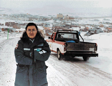
-
Article
Irishtown-Summerside
Irishtown-Summerside, NL, incorporated as a town in 1991, population 1428 (2011c), 1290 (2006c). Irishtown-Summerside is located on Humber Arm in the Bay of Islands near Corner Brook.
"https://development.thecanadianencyclopedia.ca/images/tce_placeholder.jpg?v=e9dca980c9bdb3aa11e832e7ea94f5d9" // resources/views/front/categories/view.blade.php
https://development.thecanadianencyclopedia.ca/images/tce_placeholder.jpg?v=e9dca980c9bdb3aa11e832e7ea94f5d9
-
Article
Iroquois Falls
Iroquois Falls, Ont, Town, incorporated as a town in 1915, population 4595 (2011c), 4729 (2006c). The Town of Iroquois Falls is located 334 km northwest of North Bay.
"https://development.thecanadianencyclopedia.ca/images/tce_placeholder.jpg?v=e9dca980c9bdb3aa11e832e7ea94f5d9" // resources/views/front/categories/view.blade.php
https://development.thecanadianencyclopedia.ca/images/tce_placeholder.jpg?v=e9dca980c9bdb3aa11e832e7ea94f5d9
-
Article
Jaffray Melick
Jaffray Melick, Ont, was a town from 1988 to 2000. Its former territory is now the easternmost section of the city of KENORA.
"https://d2ttikhf7xbzbs.cloudfront.net/media/media/1bf03a7f-ee0f-4f62-bd82-e4196d3f3040.jpg" // resources/views/front/categories/view.blade.php
https://d2ttikhf7xbzbs.cloudfront.net/media/media/1bf03a7f-ee0f-4f62-bd82-e4196d3f3040.jpg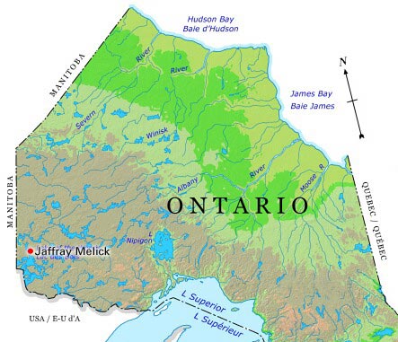
-
Article
Jasper
Jasper, Alta, incorporated as a specialized municipality in 2001, population 4051 (2011c), 4265 (2006c). The Municipality of Jasper is located at the junction of the Miette and Athabasca rivers in JASPER NATIONAL PARK, 362 km west of Edmonton.
"https://d2ttikhf7xbzbs.cloudfront.net/media/media/c315e3ee-1e50-4979-8262-d18cb2844c6e.jpg" // resources/views/front/categories/view.blade.php
https://d2ttikhf7xbzbs.cloudfront.net/media/media/c315e3ee-1e50-4979-8262-d18cb2844c6e.jpg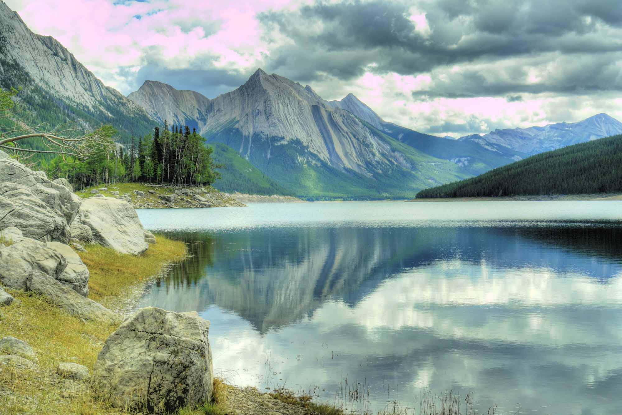
-
Article
Joliette
It was founded about 1824 by Barthélemy Joliette, seigneur de Lavaltrie, who wanted to become involved in the forestry industry. The lumber mill was one of the first buildings constructed. The town's economy diversified rapidly with the establishment of stone quarries and a foundry.
"https://development.thecanadianencyclopedia.ca/images/tce_placeholder.jpg?v=e9dca980c9bdb3aa11e832e7ea94f5d9" // resources/views/front/categories/view.blade.php
https://development.thecanadianencyclopedia.ca/images/tce_placeholder.jpg?v=e9dca980c9bdb3aa11e832e7ea94f5d9
-
Article
Jonquière
As the industrial axis of the region, its history is closely tied to the history of major corporations, specifically to that of the Price Company Ltd (now Abitibi-Price Inc) and Alcan. An agricultural parish founded in 1847, Jonquière began developing after 1893 when the railway arrived.
"https://d2ttikhf7xbzbs.cloudfront.net/media/media/21c5573a-de65-429a-b557-c72d0572f3dc.jpg" // resources/views/front/categories/view.blade.php
https://d2ttikhf7xbzbs.cloudfront.net/media/media/21c5573a-de65-429a-b557-c72d0572f3dc.jpg
-
Article
Kamloops
Kamloops, BC, incorporated as a city in 1893, population 97,902 (2021 census), 90,280 (2016 census). The City of Kamloops amalgamated with North Kamloops in 1967 and in 1973 with surrounding residential areas to form the present city of Kamloops. It is located in southern British Columbia 355 km northeast of Vancouver via the Coquihalla highway. The city is situated at the confluence of the North and South Thompson rivers near their entrance into Kamloops Lake. The Kamloops Reserve 1, home to some members of the Tk'emlúps te Secwépemc First Nation, is adjacent to the city, on the northeast corner of the river junction.
"https://development.thecanadianencyclopedia.ca/images/tce_placeholder.jpg?v=e9dca980c9bdb3aa11e832e7ea94f5d9" // resources/views/front/categories/view.blade.php
https://development.thecanadianencyclopedia.ca/images/tce_placeholder.jpg?v=e9dca980c9bdb3aa11e832e7ea94f5d9
-
Article
Kamouraska (Qué)
In 1849 the first superior court outside Québec City was established here. Incorporated as a village in 1858, Kamouraska was an important tourist area in the 19th and early 20th centuries. People came to admire the countryside, breathe the salt air and bathe in the sea.
"https://d2ttikhf7xbzbs.cloudfront.net/media/media/807c11be-1891-494f-a926-99f1c1ccd160.jpg" // resources/views/front/categories/view.blade.php
https://d2ttikhf7xbzbs.cloudfront.net/media/media/807c11be-1891-494f-a926-99f1c1ccd160.jpg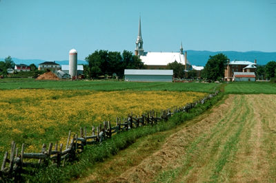
-
Article
Kamsack
Kamsack primarily serves as an agricultural service centre for the surrounding district, which contains both grain and mixed farms.
"https://development.thecanadianencyclopedia.ca/images/tce_placeholder.jpg?v=e9dca980c9bdb3aa11e832e7ea94f5d9" // resources/views/front/categories/view.blade.php
https://development.thecanadianencyclopedia.ca/images/tce_placeholder.jpg?v=e9dca980c9bdb3aa11e832e7ea94f5d9
-
Article
Kangiqsualujjuaq
A Hudson's Bay Company's trading post operated intermittently in the area from 1838 to 1952. A sawmill near the trading post attracted a permanent population, and the establishment of an arctic CHAR fishing co-operative in 1959 cemented the community's existence.
"https://d2ttikhf7xbzbs.cloudfront.net/media/media/2ddd79fe-a676-4b02-976a-d5c5001ed6a2.jpg" // resources/views/front/categories/view.blade.php
https://d2ttikhf7xbzbs.cloudfront.net/media/media/2ddd79fe-a676-4b02-976a-d5c5001ed6a2.jpg
-
Article
Kapuskasing
Kapuskasing, Ont, incorporated as a town in 1921, population 8196 (2011c), 8509 (2006c). The Town of Kapuskasing is located on the Kapuskasing River, 493 km northwest of North Bay.
"https://development.thecanadianencyclopedia.ca/images/tce_placeholder.jpg?v=e9dca980c9bdb3aa11e832e7ea94f5d9" // resources/views/front/categories/view.blade.php
https://development.thecanadianencyclopedia.ca/images/tce_placeholder.jpg?v=e9dca980c9bdb3aa11e832e7ea94f5d9
-
Article
Kaslo
Kaslo, BC, incorporated as a village in 1959, population 1026 (2011c), 1072 (2006c). The Village of Kaslo is located 70 km north of Nelson, overlooking KOOTENAY LAKE. It was established in 1892 to service the silver-mining boom sweeping the Kootenays. The origin of the name is unclear.
"https://development.thecanadianencyclopedia.ca/images/tce_placeholder.jpg?v=e9dca980c9bdb3aa11e832e7ea94f5d9" // resources/views/front/categories/view.blade.php
https://development.thecanadianencyclopedia.ca/images/tce_placeholder.jpg?v=e9dca980c9bdb3aa11e832e7ea94f5d9
-
Article
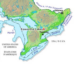
Kawartha Lakes (Ont)
Kawartha Lakes, Ontario, incorporated as a city in 2001, population 75,423 (2016 census), 73,214 (2011 census). The city of Kawartha Lakes is located almost immediately west and north of Peterborough. Kawartha Lakes was created in 2001 by the amalgamation of all the municipalities in the former county of Victoria, including Lindsay, Bobcaygeon, Verulam, Fenelon Falls, Omemee, Sturgeon Point, Woodville and 10 townships. The name is taken from the name given to a group of lakes in the area, the Kawartha Lakes. The name was given to these lakes in 1895.
"https://d2ttikhf7xbzbs.cloudfront.net/media/media/a444015a-7bdd-448d-a491-b495edd22dee.jpg" // resources/views/front/categories/view.blade.php
https://d2ttikhf7xbzbs.cloudfront.net/media/media/a444015a-7bdd-448d-a491-b495edd22dee.jpg