Canada’s rivers have played a vital role in the country’s history and cultural heritage. As transportation routes for Indigenous people and early settlers, they connected the country before railways and other modes of transportation. They have also been a source of water, food and recreation for thousands of years. Below is a list of Canada’s 10 longest rivers. The list is ordered by the river’s total length, not just the portions within Canadian borders. Similarly, the length cited is the length of the river’s main stem and does not include tributaries.
1. Yukon River: 3,185 km

In Canada, the Yukon River and its headwaters traverse the territories of the Tr’ondëk Hwëch’in, Tutchone, Tagish and Tlingit. In turn, the river is central to Indigenous cultural landscapes. The story cycle of the Athapaskan hero Tachokaii (“the Traveller”) tells of the making of both the river and time itself. According to these stories, the birchbark canoe was created on the shores of the river, where it widens into the south end of Lake Laberge. In addition to the canoe, Indigenous people also travelled the river with mooseskin boats and rafts that could carry entire households.
2. Columbia River: 2,000 km

Originally called “Rio de San Roque” by Spanish explorers, in 1792 the river was renamed “Columbia” by Boston fur trader Robert Gray, who named it after his ship. The headwaters of the Columbia River belong to the traditional territory of the Ktunaxa; the region surrounding Kinbasket Lake and Revelstoke is the traditional territory of the Secwepemc; and the area between Revelstoke and the interior Columbia Basin is the traditional territory of the Sinixt (see Interior Salish).
3. Peace River: 1,923 km

The Peace River is one of the principal tributaries of the Mackenzie River system. The name of the river refers to a settlement between Cree and Dane-Zaa (Beaver) warring parties around 1781 at Peace Point at the lower portion of the river. The Dane-Zaa word for the river is Unchaga, meaning “Big River;” the Cree word for the settlement there is Sâkitawâhk.
4. Mackenzie River: 1,738 km

The main stem of the Mackenzie River is 1,738 km long, while the entire river system is 4,241 km long. Deh Cho, the Dene name for the Mackenzie River, translates literally as “Big River.” The Inuvialuktun name, Kuukpak, means “Great River,” and the Gwich’in name, Nagwichoonjik, means “river flowing through a big country.” Each capture the great scale of the river in the landscape. Its English name derives from Alexander Mackenzie, the first European to travel the length of the river to its mouth, in 1789.
5. Churchill River: 1,609 km

The river’s name — for John Churchill, first duke of Marlborough and governor of the Hudson’s Bay Company from 1685 to 1691 — was applied to the river as early as 1686. The Cree called it Missinipi, meaning “great waters” or “big water. Churchill River issues from Churchill Lake in northwestern Saskatchewan and flows southeast, east and northeast to Hudson Bay at Churchill, Manitoba.
6. Athabasca River: 1,538 km

The Athabasca River is the longest river in Alberta. The first 168 km (located in Jasper National Park) are designated as a Canadian Heritage River. As a tributary to the Mackenzie River, water flowing on the Athabasca River eventually drains into the Arctic Ocean. There are numerous environmental stressors along the Athabasca River, including forestry, agriculture, pulp and paper mills, and the mining of the oil sands deposit.
7. South Saskatchewan River: 1,392 km

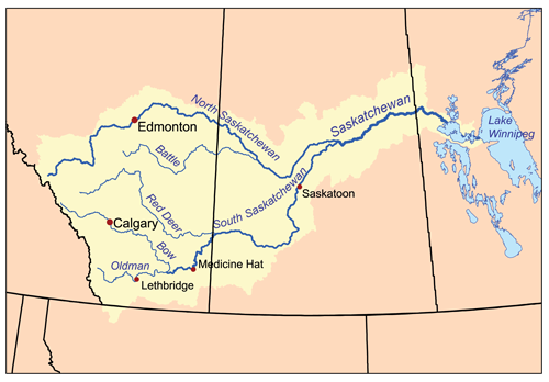
The South Saskatchewan River is a heavily utilized water source in southern Alberta and Saskatchewan. It is a major tributary to the Saskatchewan River, ultimately discharging to Hudson Bay. The South Saskatchewan River flows through an agriculturally productive region and is prone to periodic droughts and floods. Water withdrawals in the South Saskatchewan River basin are the highest of any river basin in Canada, and since 2006 the basin has been closed to new water licenses in Alberta.
8. Fraser River: 1,375 km

The Fraser River is the longest river entirely within British Columbia. It begins on the western side of the Rocky Mountains at Mount Robson Provincial Park, and ends in the Strait of Georgia at Vancouver. Named for explorer Simon Fraser, the river was a transportation route and source of food for the Indigenous people of the region long before Fraser travelled its waters. In 1858, gold was discovered on sandbars south of Yale, setting off the Fraser River gold rush.
9. North Saskatchewan River: 1,287 km

The North Saskatchewan River flows from Rocky Mountains headwaters, dominated by alpine fir, Engelmann spruce and lodgepole pine, through the foothills, traversing aspen forests and parklands, home to balsam poplar and mixed herbs and shrubs. A large portion of the river’s basin is used for agriculture, primarily cereal crops. The water quality of the North Saskatchewan is best in the headwater regions and decreases downstream due to the cumulative effects of human activity in the basin, particularly agriculture and urbanization.
10. Ottawa River: 1,271 km

The Ottawa River is the chief tributary of the St. Lawrence River. Beginning in the Laurentian Mountains, it flows west before turning southeast to form a portion of the border between Ontario and Quebec. It drains an area twice the size of New Brunswick. As the traditional territory of the Algonquin people, a key route in the fur trade and the site of a 19th-century timber boom, the Ottawa River has played an important role in Canada’s history and economy.

 Share on Facebook
 Share on X
 Share by Email
 Share on Google Classroom


