Island
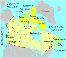
An island is a piece of land surrounded by water. By custom it is agreed that this definition does not apply to the 5 largest pieces of land that form the continents (see plate tectonics). The largest island in the world is Greenland (2 175 596 km2); the largest in Canada is Baffin Island (507 451 km2). Seventeen other Canadian islands exceed 10 000 km2 in area. The islands lying north of the mainland of Canada, are generally referred to as the Canadian Arctic Archipelago. They include the Queen Elizabeth Islands, those lying north of the strait (known successively from west to east as M'Clure Strait, Viscount Melville Sound, Barrow Strait and Lancaster Sound), which extends east-west approximately along 74° north latitude. Manitoulin Island (2765 km2), the largest island in the world located in a freshwater lake (as distinct from a flowing river), itself contains 17 lakes containing islands.
The total number of islands in Canada has never been established, but it is very large. It is estimated that there are some 30 000 islands along the eastern shore of Georgian Bay alone (the Thirty Thousand Islands). The Canadian Gazetteer Atlas (1980) records the names of 1016 individual islands and 129 groups or archipelagoes. Of these islands, 259 were recorded as inhabited in the 1976 census of Canada. At that time, Île de Montréal had the greatest population (1 869 641); the 1996 census lists the population as 1 772 505.
Origin of Islands
Islands are formed through a variety of geomorphic processes. Canadian islands fall into 2 categories: those resulting from the action of running water on an upland that has recently undergone glaciation, and those formed by the rise in sea level that normally follows an ice age. Glaciers and ice sheets are able to scoop hollows out of hard rock. If glaciation is followed by a humid period, the hollows will be filled with lakes; if the surface is sufficiently irregular, islands will occur within the lakes. The islands of the Great Lakes belong to this class.
When large rivers flow over an irregular, glaciated surface, their channels may divide to form islands (eg, those on which the cities of Montréal and Laval are found, and also the Île d'Orléans). Ice not only scoops out hollows by Erosion, it also deposits as till the material it has gathered up. The till can form natural dams impeding the flow of the rivers that drain a land surface where ice has melted. Irregularities left in glacial till may then form islands in the lakes ponded behind such dams (eg, those in Rice Lake, 95 km northeast of Toronto).
The second major group of islands, those formed by the rise in sea level following a glaciation, include the uncounted islands of Canada's Pacific, Arctic and Atlantic coasts. In most cases, the erosional action of ice causes the irregularities in the land surface that result in islands as the margins of a continent are flooded. Some islands, however, result from the deposition of till (eg, those near Lunenburg in Mahone Bay, NS).
Islands are also formed by the deposition of alluvium where the flow of water in a river is checked at or before the delta (eg, Lulu and Sea islands at the mouth of the Fraser River), and by the drifting of sand and gravel along seashores or lakeshores (eg, Toronto Islands). In some parts of the world, islands have been formed by the eruption of volcanoes and by the growth of coral. No examples of either type occur in Canada.
Finally, islands can result from human action. One, René-Levasseur (2020 km2), was formed when the waters of Réservoir Manicouagan, rising behind the Daniel Johnson Dam, surrounded Mount Babel (elevation 952 m). Approximately three-quarters the size of Manitoulin, it is the largest island in Canada formed by human activity, and may be the largest such island in the world.
See also Islands: Table; Coastal Landform; Physiographic Regions; River Landform.

 Share on Facebook
 Share on X
 Share by Email
 Share on Google Classroom


