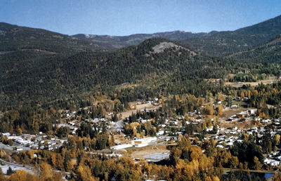
Fruitvale, BC, incorporated as a village in 1952, population 2016 (2011c), 1952 (2006c). The Village of Fruitvale is located in the southern interior of BC close to the US border, 11 km east of TRAIL, 645 km east of Vancouver. Fruitvale was originally a stop on the Great Northern Railway called Beaver Siding. In 1906 a land corporation, Fruitvale Ltd, purchased land on both sides of the stop and changed the name, to Fruitvale. The name was probably chosen as a promotional incentive. In spite of its name, however, agriculture is not the town's main economic activity. The local economic base includes smelting and refining, the production of fertilizer, lumbering and a retail and service sector. Many citizens of Fruitvale work in the neighbouring town of Trail.
-
- MLA 8TH EDITION
- . "Fruitvale". The Canadian Encyclopedia, 04 March 2015, Historica Canada. development.thecanadianencyclopedia.ca/en/article/fruitvale. Accessed 23 November 2024.
- Copy
-
- APA 6TH EDITION
- (2015). Fruitvale. In The Canadian Encyclopedia. Retrieved from https://development.thecanadianencyclopedia.ca/en/article/fruitvale
- Copy
-
- CHICAGO 17TH EDITION
- . "Fruitvale." The Canadian Encyclopedia. Historica Canada. Article published November 29, 2007; Last Edited March 04, 2015.
- Copy
-
- TURABIAN 8TH EDITION
- The Canadian Encyclopedia, s.v. "Fruitvale," by , Accessed November 23, 2024, https://development.thecanadianencyclopedia.ca/en/article/fruitvale
- Copy
Thank you for your submission
Our team will be reviewing your submission
and get back to you with any further questions.
Thanks for contributing to The Canadian Encyclopedia.
CloseArticle
Fruitvale
Published Online November 29, 2007
Last Edited March 4, 2015
Fruitvale, BC, incorporated as a village in 1952, population 2016 (2011c), 1952 (2006c). The Village of Fruitvale is located in the southern interior of BC close to the US border, 11 km east of TRAIL, 645 km east of Vancouver.