The Harder site (Borden No. FbNs-1) is situated on the northern periphery of North America's Great Plains. It contains the buried remains of an ancient bison hunters' campsite (see Aboriginal People: Plains). Named for a family living nearby, the site occupies a shallow dune depression within the Dunfermline sand hills. These sand hills form an undulating, partially wooded dune field about 28 km in length by 16 km in width with a northwest to southeast orientation. Surrounding the sand hills are flat, cultivated farmlands, once part of a vast grassland which pastured millions of wild bison. Twelve kilometres north of the sand hills one finds the deeply entrenched North Saskatchewan River. Six kilometres to the west, also deeply entrenched, is Eagle Creek. These are the major sources of potable water in a generally dry landscape. The Harder site offered its occupants access to nearby bison pastures and also a measure of protection from the winds which sweep this region, predominantly from the northwest.
Discovery and Investigation
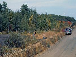
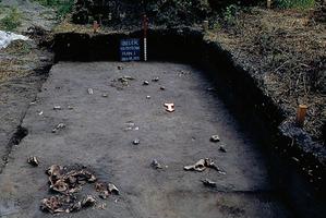
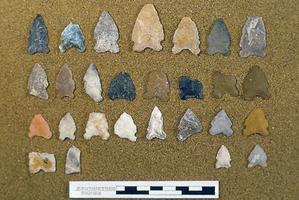
Archaeologist Ian Dyck discovered the Harder site in June of 1969 as part of a search for settlements belonging to the Oxbow archaeological culture in south central Saskatchewan. While searching a new municipal road, Dyck discovered broken animal bones, fire-broken stones, chipped stone debris and the odd chipped stone tool littering the surface and shoulders of the road in one particular dune depression. The square cut of the ditch revealed the buried occupation stratum from which these materials were derived - about 40-50 cm below the modern surface. However, it was impossible to identify the archaeological culture to which these remains belonged until the fourth visit, when an accompanying fellow graduate student, David Meyer, found on the road a projectile point diagnostic of the Oxbow tradition. Soon afterward, Dyck's family and several friends volunteered as excavation assistants so that the Oxbow occupation level could be exposed and recorded in several test pits. He returned to the site for parts of the next three summers with a combination of paid assistants and volunteers to expand the excavations to a total of 130 square meters of controlled horizontal exposure along both sides of the road, plus 67 lineal meters of deep trench profiles perpendicular to the road. The purpose of this additional work was to discover the structure, contents, occupation activities and perimeter of the site, to the extent that a moderately large sample would allow.
Site Contents, Structures and Activities
The size of the site was estimated to be at least 1000 square meters, and the area excavated (the sample) represented approximately 13% of the total. Faunal remains (see zooarchaeology) included the partial and severely broken skeletons of 17 bison, which can be extrapolated to a total of between 93 and 138 bison for the whole site. Other animals were represented by a much smaller numbers of bones: canids (wolves, dogs and/or coyotes), moose, fox, rabbit and marten.
There were at least six large, roughly circular concentrations of material remains which were interpreted as dwelling floors. These measured about 6 m in diameter and were approximately the size of a large tipi floor. Based on estimates for historic tipis, they may have housed about 42 people. Within and near these dwelling floors were a number of smaller features such as hearths, smudge pits and piles of trash. Concentrated within the dwelling floors, but also scattered between them, were 188 chipped stone tools or broken tool parts (projectile points, end scrapers, bifaces and uniface knives, drills, and miscellaneous tools); 6 bone tools (awls, spatulas, choppers), hundreds of medium and small pieces of fire-broken rock; a number of other pieces of rock variously used as large and small hammer stones, anvils, small chipping hammers (for stone tool manufacture), and abraders.
These remains are consistent with such activities as cutting and cooking bison meat; butchering canids for their pelts and possibly also their meat; breaking and heating bones for marrow extraction; cleaning, tanning and smoking of hides; use, repair, discard, manufacture and replacement of stone tools - all typical of a bison hunters' campsite.
Periods of Occupation and Cultural Affiliation
The Harder site is dominated by evidence for a single Oxbow culture occupation. However, above that occupation, at the contact between organic matter of the modern surface and the immediately underlying soil, a few fragments of bone and stone chips were found indicating that there was also a late pre-contact or early post-contact (circa AD 1750) occupation. Very little is known about that phase of site use. As to the Oxbow component, the first two radiocarbon dates on samples of bone produced an anomalously young age of about 3400 years. Three additional radiocarbon assessments produced one more date in the order of 3400 years and two others in the anticipated range of 4200 to 4400 years. Since it appears that the Oxbow component represents a single occupation, we are left with an imprecise age estimate of 3400 to 4400 years, possibly due to contamination of some of the bone by ground water. The time of year during which the site was occupied, however, is known more precisely. Both Ian Dyck's original study and a restudy by Richard Morlan some 17 years later indicated that the site was occupied in winter, possibly during December and/or January.
Site Significance
The Harder site yielded the first large scale examination of an Oxbow campsite in the Northern Great Plains providing a sample of remains three times larger than any previous Oxbow site. This provided sufficient data to open a wide range of research questions. In view of the site's continuing research value, the Province of Saskatchewan declared the site a protected area during the mid-1970s.

 Share on Facebook
 Share on X
 Share by Email
 Share on Google Classroom


