Saint-Luc
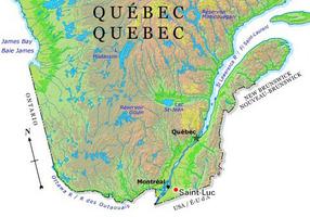
Saint-Luc, Qué, city, pop 20 573 (2001c), 18 371 (1996c), 15 008 (1991c), pop 10 951 (1986c) inc 1963, area of 51.51 km2. It is situated in the Montérégie region, well known for its apple orchards, vineyards, and sugaring-off time in the spring. The Montérégiennes are 6 hills found in the centre of the Saint-Laurent plains. A nature study centre and a conservation centre are located on each of the hills. The Rivière Richelieu is located east of the city and the Rivière L'Acadie is found to the west. Saint-Luc has access to these many natural spaces and is only a 20-minute drive from downtown Montréal.
Saint-Luc was named by association with the neighbouring parishes of St-Martin and St-Marc. In 1963 it incorporated as the city of Saint-Luc with a population of 3218. Eel fishing was one of the mainstays of the economy. This industry remains part of present-day Saint-Luc.
Saint-Luc is part of the area named the Haut-Richelieu. This area was a natural port of entry to the country that was in need of defence. The Amerindians, French and English fought for dominance of the Haut-Richelieu.
Being in close proximity to Montréal, Saint-Luc has become a residential suburb of Montréal. The main industrial companies in Saint-Luc are Tremca inc and Richelieu Metal Inc. Saint-Luc is also situated near St. Jean-sur-Richelieu military base.
Saint-Luc's wildlife museum has an impressive collection. Additionally, Saint-Luc hosts a hot-air balloon celebration, the Festival Montgolfières du Haut-Richelieu.

 Share on Facebook
 Share on X
 Share by Email
 Share on Google Classroom

