Browse "Cities"
-
Article
Abbotsford
Abbotsford, British Columbia, incorporated as a city in 1995, population 153,524 (2021 census), 141,397 (2016 census). The amalgamation of the district municipalities of Matsqui and Abbotsford formed the city of Abbotsford. Abbotsford is located on the south bank of the Fraser River, 76 km east of Vancouver. The city is named after Harry Braithwaite Abbott, the general superintendent for the British Columbia division of the Canadian Pacific Railway. Abbotsford is BC's fifth most populous municipality.
"https://development.thecanadianencyclopedia.ca/images/tce_placeholder.jpg?v=e9dca980c9bdb3aa11e832e7ea94f5d9" // resources/views/front/categories/view.blade.php
https://development.thecanadianencyclopedia.ca/images/tce_placeholder.jpg?v=e9dca980c9bdb3aa11e832e7ea94f5d9
-
Article
Airdrie
Airdrie, AB, incorporated as a city in 1985, population 61,581 (2016 census), 42,564 (2011 census).
"https://development.thecanadianencyclopedia.ca/images/tce_placeholder.jpg?v=e9dca980c9bdb3aa11e832e7ea94f5d9" // resources/views/front/categories/view.blade.php
https://development.thecanadianencyclopedia.ca/images/tce_placeholder.jpg?v=e9dca980c9bdb3aa11e832e7ea94f5d9
-
Article
Anjou
First part of the parish municipality of Saint-Léonard-de-Port-Maurice from 1886 to 1916, it was set up as a separate municipality in 1916 and incorporated as a city 50 years later.
"https://development.thecanadianencyclopedia.ca/images/tce_placeholder.jpg?v=e9dca980c9bdb3aa11e832e7ea94f5d9" // resources/views/front/categories/view.blade.php
https://development.thecanadianencyclopedia.ca/images/tce_placeholder.jpg?v=e9dca980c9bdb3aa11e832e7ea94f5d9
-
Article
Armstrong
Armstrong, BC, incorporated as a city in 1913, population 4815 (2011c), 4241 (2006c). The City of Armstrong is the business centre of a farm and forest economy of the Spallumcheen district. It is at the north end of the Okanagan Valley 23 km N of Vernon and 13 km S of Enderby.
"https://development.thecanadianencyclopedia.ca/images/tce_placeholder.jpg?v=e9dca980c9bdb3aa11e832e7ea94f5d9" // resources/views/front/categories/view.blade.php
https://development.thecanadianencyclopedia.ca/images/tce_placeholder.jpg?v=e9dca980c9bdb3aa11e832e7ea94f5d9
-
Article
Baie-Comeau
Its geographic advantages (deep bay, neighbouring rivers with strong flows, huge forestry resources) led Colonel Robert R. McCormick, publisher of The Chicago Tribune, to build a paper mill and create a town in 1937. It took the name of Napoléon-Alexandre Comeau, a celebrated north shore naturalist.
"https://development.thecanadianencyclopedia.ca/images/tce_placeholder.jpg?v=e9dca980c9bdb3aa11e832e7ea94f5d9" // resources/views/front/categories/view.blade.php
https://development.thecanadianencyclopedia.ca/images/tce_placeholder.jpg?v=e9dca980c9bdb3aa11e832e7ea94f5d9
-
Article
Barrie
Barrie, Ontario, incorporated as a city in 1959, population 147,829 (2021 census), 141,434 (2016 census). Barrie is located at the head of Kempenfelt Bay, on the western edge of Lake Simcoe. Located within Simcoe County, Barrie shares borders with the municipalities of Oro-Medonte, Springwater, Essa and Innisfil. Throughout history, the Barrie area has been home to different Indigenous groups, namely the Huron-Wendat, Haudenosaunee and Anishinaabeg peoples. The land is covered by Treaties 16 and 18.
"https://d2ttikhf7xbzbs.cloudfront.net/media/new_article_images/Barrie/Cityscape.jpg" // resources/views/front/categories/view.blade.php
https://d2ttikhf7xbzbs.cloudfront.net/media/new_article_images/Barrie/Cityscape.jpg
-
Article
Bécancour
The city is named for René Robineau de Bécancour, who led an expedition against the Iroquois in 1696. The first French missionary contact with the local Abenaki occurred in 1669, and a permanent European settlement was established 3 years later.
"https://development.thecanadianencyclopedia.ca/images/tce_placeholder.jpg?v=e9dca980c9bdb3aa11e832e7ea94f5d9" // resources/views/front/categories/view.blade.php
https://development.thecanadianencyclopedia.ca/images/tce_placeholder.jpg?v=e9dca980c9bdb3aa11e832e7ea94f5d9
-
Article
Belleville
Belleville, Ontario, incorporated as a city in 1877, population 55,071 (2021 census), 50,716 (2016 census). The city of Belleville, the seat of Hastings County, is located on the Bay of Quinte, an arm of Lake Ontario about 180 km east of Toronto at the mouth of the Moira River.
"https://development.thecanadianencyclopedia.ca/images/tce_placeholder.jpg?v=e9dca980c9bdb3aa11e832e7ea94f5d9" // resources/views/front/categories/view.blade.php
https://development.thecanadianencyclopedia.ca/images/tce_placeholder.jpg?v=e9dca980c9bdb3aa11e832e7ea94f5d9
-
Article
Brampton
Brampton, Ontario, incorporated as a city in 1974, population 656,480 (2021 census), 593,638 (2016 census). The city of Brampton was created by the amalgamation of the Town of Brampton, the southern half of Chinguacousy Township, and portions of the Town of Mississauga and Toronto Gore Township. Located northwest of Toronto, Brampton is part of the Regional Municipality of Peel. It is located within the Credit and Humber River watersheds. Throughout history, the Brampton area has been home to different Indigenous groups, namely the Wendat (Huron), Haudenosaunee and Anishinaabeg, including the Mississaugas of the Credit. The land is covered by the Ajetance Purchase (1818).
"https://d2ttikhf7xbzbs.cloudfront.net/media/new_article_images/Brampton/1BramptonPicture.jpg" // resources/views/front/categories/view.blade.php
https://d2ttikhf7xbzbs.cloudfront.net/media/new_article_images/Brampton/1BramptonPicture.jpg
-
Article
Brandon
Brandon, Manitoba, incorporated as a city in 1882, population 51,313 (2021 census), 48,883 (2016 census). The City of Brandon, the province's second-largest city and economic hub of its southwestern region, is located on the Assiniboine River, 197 km west of Winnipeg.
"https://d2ttikhf7xbzbs.cloudfront.net/media/media/4112eb2b-9753-45c6-b355-904d9a519a46.jpg" // resources/views/front/categories/view.blade.php
https://d2ttikhf7xbzbs.cloudfront.net/media/media/4112eb2b-9753-45c6-b355-904d9a519a46.jpg
-
Article
Brantford
Brantford, ON, incorporated as a city in 1877, population 97,496 (2016 census), 93,650 (2011 census). The City of Brantford is located on the Grand River, 104 km southwest of Toronto. It is home to several manufacturing industries, educational institutions and heritage sites.
"https://d2ttikhf7xbzbs.cloudfront.net/media/media/4e9bdb40-6a17-4aed-8166-559a7b871ae7.jpg" // resources/views/front/categories/view.blade.php
https://d2ttikhf7xbzbs.cloudfront.net/media/media/4e9bdb40-6a17-4aed-8166-559a7b871ae7.jpg
-
Article
Brockville
Brockville, Ont, incorporated as a city in 1962, population 21 870 (2011c), 21 957 (2006c). The City of Brockville is located on the St Lawrence River, 80 km east of Kingston.
"https://d2ttikhf7xbzbs.cloudfront.net/media/media/22f08ba6-1b15-4ad2-8735-6081fd45a518.jpg" // resources/views/front/categories/view.blade.php
https://d2ttikhf7xbzbs.cloudfront.net/media/media/22f08ba6-1b15-4ad2-8735-6081fd45a518.jpg
-
Article
Brooks
Brooks, Alta, incorporated as a city in 2005, population 13 676 (2011c), 12 508 (2006c). The City of Brooks is located 185 km southeast of Calgary on the Trans-Canada Highway.
"https://development.thecanadianencyclopedia.ca/images/tce_placeholder.jpg?v=e9dca980c9bdb3aa11e832e7ea94f5d9" // resources/views/front/categories/view.blade.php
https://development.thecanadianencyclopedia.ca/images/tce_placeholder.jpg?v=e9dca980c9bdb3aa11e832e7ea94f5d9
-
Article
Burlington
Burlington, Ontario, population 186,948 (2021 census), 183,314 (2016 census), is located at the head of Lake Ontario. It borders Hamilton, Milton and Oakville. Burlington was first incorporated in 1873 as a village, as a town in 1915, and as a city in 1974. Amalgamation created the modern boundaries in 1958, combining the Town of Burlington, Nelson Township, and part of East Flamborough Township. Throughout history, the Burlington area has been home to different Indigenous groups, namely the Neutral, Haudenosaunee and Anishinaabeg, including the Mississauga. The land is covered by treaties 3, 8, 14 and 19 (see Upper Canada Land Surrenders).
"https://d2ttikhf7xbzbs.cloudfront.net/media/media/36ed4822-e26d-4d96-9391-164cab4d1da0.jpg" // resources/views/front/categories/view.blade.php
https://d2ttikhf7xbzbs.cloudfront.net/media/media/36ed4822-e26d-4d96-9391-164cab4d1da0.jpg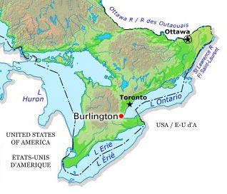
-
Article
Burnaby
Burnaby, BC, incorporated as a city in 1992, population 249,125 (2021 census), 232,755 (2016 census). Burnaby adjoins Vancouver on the west, Coquitlam on the east and New Westminster on the southeast. Named after Robert Burnaby, a businessman and legislator of the 1860s, it features Burnaby Mountain (365 m), Burnaby Lake, the Fraser River and Burrard Inlet. Burnaby was a district municipality for one hundred years before being granted civic status in 1992. It is governed by a mayor and eight councillors and is a member Metro Vancouver. (See also Municipal Government in Canada.)
"https://d2ttikhf7xbzbs.cloudfront.net/media/media/2bd7362f-7692-4d30-b07f-0cde82e5492a.jpg" // resources/views/front/categories/view.blade.php
https://d2ttikhf7xbzbs.cloudfront.net/media/media/2bd7362f-7692-4d30-b07f-0cde82e5492a.jpg