Browse "Cities"
-
Article
Saint-Romuald
Saint-Romuald, Quebec, population 13,435 (2019), 10,825 (2001 census). Originally incorporated in 1965, Saint-Romuald is located on the south shore of the St. Lawrence River. It is across from Sillery and is situated 19 km south of Quebec City. Since 2002, Saint-Romuald is part of the city of Lévis.
"https://d2ttikhf7xbzbs.cloudfront.net/media/media/Saint-romuald.jpg" // resources/views/front/categories/view.blade.php
https://d2ttikhf7xbzbs.cloudfront.net/media/media/Saint-romuald.jpg
-
Article
Sainte-Anne-des-Plaines
The serene country atmosphere that surrounds Sainte-Anne-des-Plaines is complemented by the rich architectural heritage that is to be found in the city centre.
"https://development.thecanadianencyclopedia.ca/images/tce_placeholder.jpg?v=e9dca980c9bdb3aa11e832e7ea94f5d9" // resources/views/front/categories/view.blade.php
https://development.thecanadianencyclopedia.ca/images/tce_placeholder.jpg?v=e9dca980c9bdb3aa11e832e7ea94f5d9
-
Article
Sainte-Catherine
Sainte-Catherine was the original site of the Jesuit Iroquois mission founded in 1676 and later moved to Caughnawaga (now Kahnawake). The name Sainte-Catherine was quite probably chosen in honour of Kateri (Catherine) TEKAKWITHA. Her empty tomb is located across from the Roman Catholic church.
"https://development.thecanadianencyclopedia.ca/images/tce_placeholder.jpg?v=e9dca980c9bdb3aa11e832e7ea94f5d9" // resources/views/front/categories/view.blade.php
https://development.thecanadianencyclopedia.ca/images/tce_placeholder.jpg?v=e9dca980c9bdb3aa11e832e7ea94f5d9
-
Article
Sainte-Julie
Sainte-Julie is mainly a residential city that prides itself on being "the city in the country.
"https://development.thecanadianencyclopedia.ca/images/tce_placeholder.jpg?v=e9dca980c9bdb3aa11e832e7ea94f5d9" // resources/views/front/categories/view.blade.php
https://development.thecanadianencyclopedia.ca/images/tce_placeholder.jpg?v=e9dca980c9bdb3aa11e832e7ea94f5d9
-
Article
Sainte-Thérèse
In 1714, Gaspard Piot de Langloiserie and his spouse, Marie-Thérèse du Gué, received the seigneury of Mille-Iles. In 1735 colonization occurred mainly through the efforts of the widow Marie-Thérèse du Gué and continued through her descendants.
"https://d2ttikhf7xbzbs.cloudfront.net/media/media/f7a52485-afe1-4d76-b238-1193aa14bdeb.jpg" // resources/views/front/categories/view.blade.php
https://d2ttikhf7xbzbs.cloudfront.net/media/media/f7a52485-afe1-4d76-b238-1193aa14bdeb.jpg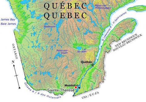
-
Article
Salaberry-de-Valleyfield
Salaberry-de-Valleyfield draws its labour force from the local population and its history is marked by often violent labour disputes (see COMPANY TOWNS). Originally (1874) it was called Salaberry, in honour of Charles d'Irumberry de SALABERRY.
"https://development.thecanadianencyclopedia.ca/images/tce_placeholder.jpg?v=e9dca980c9bdb3aa11e832e7ea94f5d9" // resources/views/front/categories/view.blade.php
https://development.thecanadianencyclopedia.ca/images/tce_placeholder.jpg?v=e9dca980c9bdb3aa11e832e7ea94f5d9
-
Article
Salmon Arm
Salmon Arm, British Columbia, incorporated as a city in 2005, population 17,706 (2016 census), 17,464 (2011 census). The city of Salmon Arm is located at the head of the southwestern arm of Shuswap Lake, also called Salmon Arm, 110 km east of Kamloops.
"https://d2ttikhf7xbzbs.cloudfront.net/media/media/13d5ba26-c992-4341-99fa-c71c6fe1dc4f.jpg" // resources/views/front/categories/view.blade.php
https://d2ttikhf7xbzbs.cloudfront.net/media/media/13d5ba26-c992-4341-99fa-c71c6fe1dc4f.jpg
-
Article
Sarnia
Sarnia, Ontario, incorporated as a city in 1914, population 71,594 (2016 c), 72,366 (2011 c). The City of Sarnia is located at the convergence of the St. Clair River and Lake Huron, 100 km west of London. A railway tunnel beneath the St. Clair and a highway bridge from nearby Point Edward connect Sarnia with Port Huron, Michigan. Sarnia is a major centre for the petrochemical industry and the southern terminus of an oil pipeline from Alberta. It was also the home of Alexander Mackenzie, first Liberal prime minister of Canada.
"https://d2ttikhf7xbzbs.cloudfront.net/media/media/35d2cb6f-0ea1-4258-9795-68b7ab247e24.jpg" // resources/views/front/categories/view.blade.php
https://d2ttikhf7xbzbs.cloudfront.net/media/media/35d2cb6f-0ea1-4258-9795-68b7ab247e24.jpg
-
Article
Saskatoon
Saskatoon, Saskatchewan, incorporated as a city in 1906, population 266,141 (2021 census), 247,201 (2016 census). The City of Saskatoon, the largest city in Saskatchewan, is situated in rolling parklands on the banks of the northward-flowing South Saskatchewan River, 352 km northwest of Regina. It serves as regional centre for the northern prairies and for central and northern Saskatchewan. It is noted for its extensive riverbank parks and trails, wide tree-lined streets and attractive University of Saskatchewan campus.
"https://d2ttikhf7xbzbs.cloudfront.net/media/media/c4ed4d03-e017-484f-b344-935c8f3295e8.jpg" // resources/views/front/categories/view.blade.php
https://d2ttikhf7xbzbs.cloudfront.net/media/media/c4ed4d03-e017-484f-b344-935c8f3295e8.jpg
-
Article
Sept-Îles
The first permanent European settlement dates from 1651: the Ange-Gardien mission founded by Father Jean de Quen. A trading and fishing post set up there in 1676 by Louis Jolliet was ceded in the 19th century to the Hudson's Bay Company.
"https://d2ttikhf7xbzbs.cloudfront.net/media/media/b58f3f0e-84bf-496f-92f5-a676522afa6c.jpg" // resources/views/front/categories/view.blade.php
https://d2ttikhf7xbzbs.cloudfront.net/media/media/b58f3f0e-84bf-496f-92f5-a676522afa6c.jpg
-
Article
Shawinigan
After 1825 the government of Lower Canada had the territory of the Mauricie region surveyed. The first concessions were given out in 1831. Shawinigan was first the site of a waterslide (1852) built so that log booms could be sent downstream to Trois-Rivières.
"https://development.thecanadianencyclopedia.ca/images/tce_placeholder.jpg?v=e9dca980c9bdb3aa11e832e7ea94f5d9" // resources/views/front/categories/view.blade.php
https://development.thecanadianencyclopedia.ca/images/tce_placeholder.jpg?v=e9dca980c9bdb3aa11e832e7ea94f5d9
-
Article
Sorel-Tracy
Sorel-Tracy, Quebec, incorporated as a city in 2000, population 35,165 (2021 census), 34,755 (2016 census). Sorel-Tracy is located on the south shore of the St. Lawrence River, at the mouth of the Richelieu River, approximately 80 km northeast of Montreal. Sorel-Tracy is the result of the voluntary amalgamation of the municipalities of Sorel (founded in 1642) and Tracy (incorporated in 1954) in 2000. Sorel-Tracy is known for its industrial port and metallurgy industry.
"https://d2ttikhf7xbzbs.cloudfront.net/media/media/d6a8cdc3-649a-4920-9797-0bfec5539b5f.jpg" // resources/views/front/categories/view.blade.php
https://d2ttikhf7xbzbs.cloudfront.net/media/media/d6a8cdc3-649a-4920-9797-0bfec5539b5f.jpg
-
Article
Spruce Grove
Spruce Grove, Alta, incorporated as a city in 1986, population 26 171 (2011c), 19 541 (2006c). The City of Spruce Grove is located just west of Edmonton and is the eastern neighbour of the town STONY PLAIN. French and Scottish settlers arrived in 1891.
"https://development.thecanadianencyclopedia.ca/images/tce_placeholder.jpg?v=e9dca980c9bdb3aa11e832e7ea94f5d9" // resources/views/front/categories/view.blade.php
https://development.thecanadianencyclopedia.ca/images/tce_placeholder.jpg?v=e9dca980c9bdb3aa11e832e7ea94f5d9
-
Article
St Albert
St Albert, Alta, incorporated as a city in 1977, population 61 466 (2011c), 57 764 (2006c). The City of St Albert is located along the northwestern city boundary of EDMONTON.
"https://d2ttikhf7xbzbs.cloudfront.net/media/media/d0a2938b-4548-4d63-8063-2fa2e8a1b54e.jpg" // resources/views/front/categories/view.blade.php
https://d2ttikhf7xbzbs.cloudfront.net/media/media/d0a2938b-4548-4d63-8063-2fa2e8a1b54e.jpg
-
Article
St. Catharines
St. Catharines, ON, incorporated as a city in 1876, population 136,803 (2021 census), 133,113 (2016 census). The City of St. Catharines is the principal city of the Niagara Region. It lies south of Toronto across Lake Ontario (111 km by the Queen Elizabeth Way), 19 km inland from the international boundary with the United States, along the Niagara River. The city is named after Catharine Hamilton, wife of Robert Hamilton, an influential merchant of Queenston and a landowner with mills on Twelve Mile Creek; the growing community, then known as The Twelve or Shipman's Corners, was renamed in her honour after her death in 1796. After 1876, as the urban area of St. Catharines expanded, it was permitted to annex parts of the surrounding Grantham Township, culminating in 1961 in the complete amalgamation of the township as well as the adjacent towns of Merritton and Port Dalhousie. In 1970, the rural township of Louth to the west was split between St. Catharines and the new town of Lincoln.
"https://d2ttikhf7xbzbs.cloudfront.net/media/media/0b59b887-a76a-4eea-9406-10f64badd85e.jpg" // resources/views/front/categories/view.blade.php
https://d2ttikhf7xbzbs.cloudfront.net/media/media/0b59b887-a76a-4eea-9406-10f64badd85e.jpg