Browse "Cities"
-
Article
St. John's
St. John's, NL, incorporated as a city in 1921, population 110,525 (2021 census), 108,860 (2016 census). The capital and largest city of Newfoundland and Labrador, the city of St. John's is located on the eastern side of the Avalon Peninsula of southeast Newfoundland. Its landlocked harbour is approached through a long, narrow channel and is protected by the high hills on which the city is built. The origin of the name St. John's is not known, but its use appears on a Portuguese map by Pedro Reinel (1516–20) as "Rio de San Johem" and later, in a 1527 letter by the English seaman John Rut, as the "Haven of St. John's." According to popular folklore, however, the city takes its name from the feast of Saint John the Baptist and the arrival of Italian explorer Giovanni Caboto (John Cabot) on the shores of Newfoundland on 24 June 1497.
"https://d2ttikhf7xbzbs.cloudfront.net/media/media/fa98a7ea-65f5-47f6-9d63-252242142821.jpg" // resources/views/front/categories/view.blade.php
https://d2ttikhf7xbzbs.cloudfront.net/media/media/fa98a7ea-65f5-47f6-9d63-252242142821.jpg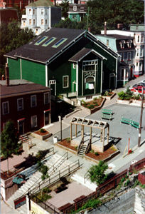
-
Article
St Thomas
St Thomas, Ont, incorporated as a city in 1881, seat of Elgin County, population 37 905 (2011c), 36 110 (2006c). The City of St Thomas is located in southwestern Ontario, 29 km south of London. In 1803 Thomas TALBOT began to place settlers on a large tract of land he owned N of Lake Erie.
"https://development.thecanadianencyclopedia.ca/images/tce_placeholder.jpg?v=e9dca980c9bdb3aa11e832e7ea94f5d9" // resources/views/front/categories/view.blade.php
https://development.thecanadianencyclopedia.ca/images/tce_placeholder.jpg?v=e9dca980c9bdb3aa11e832e7ea94f5d9
-
Article
Steinbach
Steinbach, Manitoba, incorporated as a city in 1997, population 13 524 (2011c), 11 066 (2006c). The City of Steinbach is located 48 km southeast of WINNIPEG.
"https://d2ttikhf7xbzbs.cloudfront.net/media/media/6ed4bd95-16b4-43e8-8409-f8c8d9d56b8f.jpg" // resources/views/front/categories/view.blade.php
https://d2ttikhf7xbzbs.cloudfront.net/media/media/6ed4bd95-16b4-43e8-8409-f8c8d9d56b8f.jpg
-
Article
Stratford
Urban growth was slow until the railway-building boom of the 1850s. Stratford businessmen lobbied for the forming in 1853 of the County of Perth, with Stratford as the county seat, and the county at once voted bonuses to railway companies.
"https://d2ttikhf7xbzbs.cloudfront.net/media/media/664057ff-dd11-4f37-abff-a514d6fb143e.jpg" // resources/views/front/categories/view.blade.php
https://d2ttikhf7xbzbs.cloudfront.net/media/media/664057ff-dd11-4f37-abff-a514d6fb143e.jpg
-
Article
Surrey
Surrey, British Columbia, incorporated as a city in 1993, population 568,322 (2021 census), 517,887 (2016 census). The city of Surrey is the second-largest municipality by population in British Columbia, after Vancouver. Part of Metro Vancouver, it is bounded by the Fraser River on the north and Washington state on the south. The municipalities of Langley and Delta lie to the east and west.
"https://development.thecanadianencyclopedia.ca/images/tce_placeholder.jpg?v=e9dca980c9bdb3aa11e832e7ea94f5d9" // resources/views/front/categories/view.blade.php
https://development.thecanadianencyclopedia.ca/images/tce_placeholder.jpg?v=e9dca980c9bdb3aa11e832e7ea94f5d9
-
Article
Swift Current
Swift Current began to adopt the persona of a community in 1883 with the appearance of a dam, water tank, freight sheds, roadhouse and dining room. For many years it has served a large ranching, mixed-farming and grain-farming area.
"https://d2ttikhf7xbzbs.cloudfront.net/media/media/5ff60670-5d29-40af-bc8c-2490e8c26d9d.jpg" // resources/views/front/categories/view.blade.php
https://d2ttikhf7xbzbs.cloudfront.net/media/media/5ff60670-5d29-40af-bc8c-2490e8c26d9d.jpg
-
Article
Terrace
Terrace, BC, incorporated as a city in 1987, population 11 486 (2011c), 11 320 (2006c).
"https://development.thecanadianencyclopedia.ca/images/tce_placeholder.jpg?v=e9dca980c9bdb3aa11e832e7ea94f5d9" // resources/views/front/categories/view.blade.php
https://development.thecanadianencyclopedia.ca/images/tce_placeholder.jpg?v=e9dca980c9bdb3aa11e832e7ea94f5d9
-
Article
Terrebonne
Vieux Terrebonne is a veritable heritage storehouse. The historic buildings and landmarks of the old village centre recall the role played by the NORTH WEST COMPANY in the history of Terrebonne.
"https://development.thecanadianencyclopedia.ca/images/tce_placeholder.jpg?v=e9dca980c9bdb3aa11e832e7ea94f5d9" // resources/views/front/categories/view.blade.php
https://development.thecanadianencyclopedia.ca/images/tce_placeholder.jpg?v=e9dca980c9bdb3aa11e832e7ea94f5d9
-
Article
Thetford Mines
Thetford Mines, Quebec, incorporated as a city in 1905, population 26,072 (2021 census), population 25,403 (2016 census). The city of Thetford Mines is located on the Bécancour River in the Appalachian Mountains, 107 km south of Quebec City. It was named after the town of Thetford in Norfolk, England. During the 20th century, it was one of the world’s largest asbestos mining and production centres.
"https://d2ttikhf7xbzbs.cloudfront.net/media/new_article_images/ThetfordMines/ThetfordMines.jpg" // resources/views/front/categories/view.blade.php
https://d2ttikhf7xbzbs.cloudfront.net/media/new_article_images/ThetfordMines/ThetfordMines.jpg
-
Article
Thompson
Thompson, Manitoba, incorporated as a city in 1970, population 12 829 (2011c), 13 446 (2006c). The City of Thompson is located on the south side of the Burntwood River, 740 km north of Winnipeg.
"https://d2ttikhf7xbzbs.cloudfront.net/media/media/47481ba8-856b-414e-a45d-175e7b331f81.jpg" // resources/views/front/categories/view.blade.php
https://d2ttikhf7xbzbs.cloudfront.net/media/media/47481ba8-856b-414e-a45d-175e7b331f81.jpg
-
Article
Thorold
Thorold, Ont, incorporated as a city in 1975, population 17 931 (2011c), 18 224 (2006c). The City of Thorold is situated on the NIAGARA PENINSULA. Though physically linked to ST CATHARINES, its large neighbour directly to the
"https://development.thecanadianencyclopedia.ca/images/tce_placeholder.jpg?v=e9dca980c9bdb3aa11e832e7ea94f5d9" // resources/views/front/categories/view.blade.php
https://development.thecanadianencyclopedia.ca/images/tce_placeholder.jpg?v=e9dca980c9bdb3aa11e832e7ea94f5d9
-
Article
Thunder Bay
Thunder Bay, ON, incorporated as a city in 1970, population 108,843 (2021 census), 107,909 (2016 census). The City of Thunder Bay was created by the amalgamation of the cities of Fort William and Port Arthur and the townships of Neebing and McIntyre. It is located in northwestern Ontario on the west shore of the Lake Superior bay of the same name. Thunder Bay is situated on the traditional territory of the Anishinaabeg, and the land is covered by the Robinson-Superior Treaty. The Port of Thunder Bay is a western stop along the Great Lakes-St Lawrence Seaway. The region’s geography is dominated by the rocks, lakes and forests of the Canadian Shield. Surrounding communities depend on tourism or resource extraction and look to Thunder Bay for a wide variety of services.
"https://d2ttikhf7xbzbs.cloudfront.net/media/new_article_images/ThunderBay/12171019064_8ca50f0bb8_z.jpg" // resources/views/front/categories/view.blade.php
https://d2ttikhf7xbzbs.cloudfront.net/media/new_article_images/ThunderBay/12171019064_8ca50f0bb8_z.jpg
-
Article
Timmins
Timmins, Ontario, incorporated as a city in 1973, population 41,145 (2021 census), 41,788 (2016 census). The city of Timmins is located 290 km northwest of Greater Sudbury.
"https://d2ttikhf7xbzbs.cloudfront.net/media/media/77a2b646-1dd7-44c2-8094-136b666d627e.jpg" // resources/views/front/categories/view.blade.php
https://d2ttikhf7xbzbs.cloudfront.net/media/media/77a2b646-1dd7-44c2-8094-136b666d627e.jpg
-
Article
Toronto
Toronto, Ontario, incorporated as a city in 1834, population 2,794,356 (2021 census), 2,731,571 (2016 census). Toronto is Ontario’s capital city, Canada’s largest municipality and the fourth largest city in North America (see also Largest Cities in Canada by Population). It is made up of the former cities of Toronto, North York, Scarborough, York and Etobicoke, and the former borough of East York. The city is home to a large immigrant population, and is a national and international hub for finance, communications and cultural life.
"https://d2ttikhf7xbzbs.cloudfront.net/media/media/Toronto_Skyline_2011_CityofTOFlickrCC.jpg" // resources/views/front/categories/view.blade.php
https://d2ttikhf7xbzbs.cloudfront.net/media/media/Toronto_Skyline_2011_CityofTOFlickrCC.jpg
-
Article
Trois-Rivières
Trois-Rivières, Quebec, incorporated as a city in 1857, population 139,163 (2021 census), 134,413 (2016 census). The city is located at the mouth of the Saint-Maurice River, on the north shore of the St. Lawrence, midway between Quebec City and Montreal and is the regional capital of Quebec's Mauricie region. Its name derives from the 3-armed delta formed by the river's islands at its mouth.
"https://d2ttikhf7xbzbs.cloudfront.net/media/media/f64e6118-f564-4f2e-aee3-8d7194dda785.jpg" // resources/views/front/categories/view.blade.php
https://d2ttikhf7xbzbs.cloudfront.net/media/media/f64e6118-f564-4f2e-aee3-8d7194dda785.jpg