Browse "Cities"
-
Article
Laterrière
The name was first applied to the township (1850) and then the parish (1882). They were named after Marc-Pascal de Sales Laterrière, who represented Saguenay in the Legislative Assembly of the Province of Canada.
"https://d2ttikhf7xbzbs.cloudfront.net/media/media/b129fc4e-8039-4ddb-b986-6065a9b74dc1.jpg" // resources/views/front/categories/view.blade.php
https://d2ttikhf7xbzbs.cloudfront.net/media/media/b129fc4e-8039-4ddb-b986-6065a9b74dc1.jpg
-
Article
Laval
Laval, Quebec, incorporated as a city in 1965, population 438,366 (2021 census), 422,993 (2016 census). Laval was formed by the merger of 14 municipalities: Chomedey, Duvernay, Laval-des-Rapides, Laval-Ouest, Pont-Viau, Sainte-Rose, Auteuil, Fabreville, Îles-Laval, Laval-sur-le-lac, Sainte-Dorothée, Saint-François, Saint-Vincent-de-Paul and Vimont. Laval is the third largest city in Quebec. It is located on Île Jésus, north of Île de Montréal. Laval is separated from Île de Montréal by the Rivière des Prairies and from the mainland to the north by the Rivière des Mille Îles. The city is named after François de Laval, the first Roman Catholic bishop of Quebec (1674-88) and onetime seigneur (1675-80) of Île Jésus.
"https://development.thecanadianencyclopedia.ca/images/tce_placeholder.jpg?v=e9dca980c9bdb3aa11e832e7ea94f5d9" // resources/views/front/categories/view.blade.php
https://development.thecanadianencyclopedia.ca/images/tce_placeholder.jpg?v=e9dca980c9bdb3aa11e832e7ea94f5d9
-
Article
Le Gardeur
First set up as the parish municipality of Saint-Paul-l'Ermite in 1857, it was incorporated as a city under the same name in 1973 before changing its designation to Le Gardeur in 1978.
"https://development.thecanadianencyclopedia.ca/images/tce_placeholder.jpg?v=e9dca980c9bdb3aa11e832e7ea94f5d9" // resources/views/front/categories/view.blade.php
https://development.thecanadianencyclopedia.ca/images/tce_placeholder.jpg?v=e9dca980c9bdb3aa11e832e7ea94f5d9
-
Article
Lethbridge
Lethbridge, AB, incorporated as a city in 1906, population 98,406 (2021 census), 92,729 (2016 census). The City of Lethbridge is located 215 km southeast of Calgary. It overlooks the steep valley of the Oldman River.
"https://d2ttikhf7xbzbs.cloudfront.net/media/media/51fd07bf-2ce7-4c0f-9eb0-7665f2c6b528.jpg" // resources/views/front/categories/view.blade.php
https://d2ttikhf7xbzbs.cloudfront.net/media/media/51fd07bf-2ce7-4c0f-9eb0-7665f2c6b528.jpg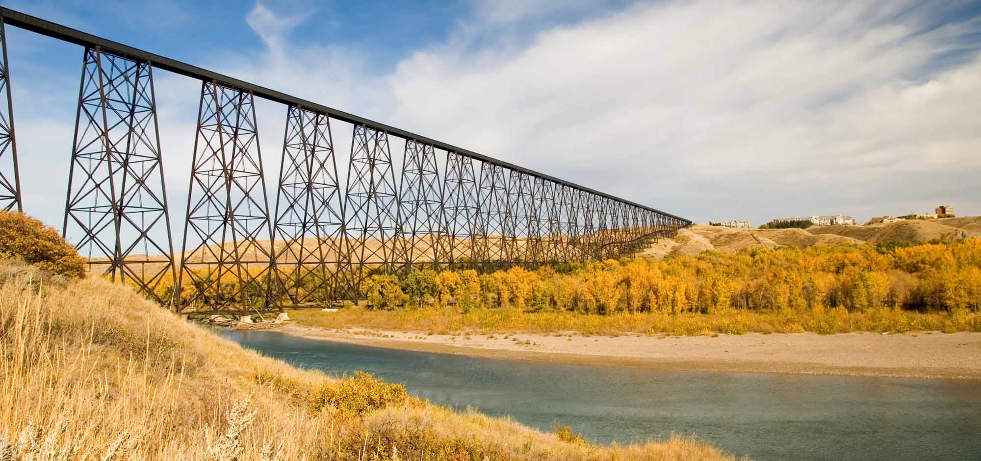
-
Article
Lévis
Lévis, Quebec, city incorporated in 2002, population 143,414 (2016 census), 138,769 (2011 census). Lévis covers an area of 444 km2. The city is located on the rocky cliffs opposite Quebec City, to which it is linked by ferry. Present-day Lévis is the result of multiple mergers. In 1989, it merged with the industrial city of Lauzon (inc 1957). The following year, Lévis combined with the town of Saint-David-de-l'Auberivière. In 2002, Lévis took in the cities of Charny, Saint-Jean-Chrysostome, Saint-Nicolas, Saint-Rédempteur and Saint-Romuald. The parishes of Saint-Joseph-de-la-Pointe-de-Lévy and Sainte-Hélène-de-Breakeyville were also included in the fusion. The municipalities of Pintendre, Saint-Étienne-de-Lauzon, Desjardins and Chutes-de-la-Chaudière were also merged in.
"https://d2ttikhf7xbzbs.cloudfront.net/media/media/1024px-Ville_de_Lévis01.jpg" // resources/views/front/categories/view.blade.php
https://d2ttikhf7xbzbs.cloudfront.net/media/media/1024px-Ville_de_Lévis01.jpg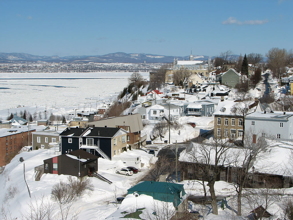
-
Article
Lloydminster
Lloydminster, Alberta and Saskatchewan, incorporated as a city in 1958, population 19,739 in Alberta and 11,843 in Saskatchewan (2021 census); 19,645 in Alberta and 11,765 in Saskatchewan (2016 census). The city of Lloydminster is known as the “Border City” since it is located on the Saskatchewan-Alberta border, about 275 km west of Saskatoon and 250 km east of Edmonton. It is one of two communities in Canada split by a provincial boundary, the other being Flin Flon, Manitoba.
"https://d2ttikhf7xbzbs.cloudfront.net/media/media/94afb778-e678-4eb6-999e-e723944f1edd.jpg" // resources/views/front/categories/view.blade.php
https://d2ttikhf7xbzbs.cloudfront.net/media/media/94afb778-e678-4eb6-999e-e723944f1edd.jpg
-
Article
London
London, Ont, incorporated as a city in 1855, population 366 151 (2011c), 352 395 (2006c). The City of London, the seat of Middlesex County, is centrally located in the southwest peninsula of the province, on the Québec-Windsor corridor midway between Toronto (185 km) and Windsor (190 km).
"https://d2ttikhf7xbzbs.cloudfront.net/media/media/05fb552e-40ae-4290-9740-edbcca6e04db.jpg" // resources/views/front/categories/view.blade.php
https://d2ttikhf7xbzbs.cloudfront.net/media/media/05fb552e-40ae-4290-9740-edbcca6e04db.jpg
-
Article
Longueuil
Longueuil, Quebec, population 239,700 (2016 census), 231,409 (2011 census). Longueuil’s history dates to the 17th century with the settling of French colonists. It is today an important suburb of Montreal and is connected to the island of Montreal by the Jacques Cartier bridge and the Louis-Hippolyte-La Fontaine tunnel-bridge. Longueuil is criss-crossed by major expressways linking metropolitan Montreal to Québec city, the Eastern Townships and northern New York State. The municipality of Longueuil is its own entity within the Longueuil agglomeration which includes other nearby cities.Longueuil is situated on the ancestral territory of the Kanyen’kehà:ka. The land remains unceded and is considered Indigenous territory.
"https://d2ttikhf7xbzbs.cloudfront.net/media/single_use_images/cocathédrale longueuil_cropped.png" // resources/views/front/categories/view.blade.php
https://d2ttikhf7xbzbs.cloudfront.net/media/single_use_images/cocathédrale longueuil_cropped.png
-
Article
Mascouche
The history of Mascouche was closely linked to the roles played by Gabriel Christie and Peter and his son John Pangman, 3 of the last owners of the Seigneury de La Chesnaye.
"https://development.thecanadianencyclopedia.ca/images/tce_placeholder.jpg?v=e9dca980c9bdb3aa11e832e7ea94f5d9" // resources/views/front/categories/view.blade.php
https://development.thecanadianencyclopedia.ca/images/tce_placeholder.jpg?v=e9dca980c9bdb3aa11e832e7ea94f5d9
-
Article
Medicine Hat
Medicine Hat, Alberta, incorporated as a city in 1906, population 63,271 (2021 census), 63,260 (2016 census). The city of Medicine Hat is one of Alberta's largest cities. It is located on the Canadian Pacific Railway main line and the Trans-Canada Highway in the southeastern corner of the province, bisected by the South Saskatchewan River. Canada's “sunniest” city, Medicine Hat averages 330 days of sunshine per year. A council of eight councillors and a mayor govern the city.
"https://d2ttikhf7xbzbs.cloudfront.net/media/media/3897d8ea-97cb-4069-8f58-433a41de83d2.jpg" // resources/views/front/categories/view.blade.php
https://d2ttikhf7xbzbs.cloudfront.net/media/media/3897d8ea-97cb-4069-8f58-433a41de83d2.jpg
-
Article
Melfort
The rail line, which arrived in 1909, made Melfort a trade and cultural centre for the surrounding area. It was incorporated as a village in 1903, as a town in 1907 and a city in 1980.
"https://development.thecanadianencyclopedia.ca/images/tce_placeholder.jpg?v=e9dca980c9bdb3aa11e832e7ea94f5d9" // resources/views/front/categories/view.blade.php
https://development.thecanadianencyclopedia.ca/images/tce_placeholder.jpg?v=e9dca980c9bdb3aa11e832e7ea94f5d9
-
Article
Melville
The community's growth beyond that of others in the area came as a result of its designation as a divisional point by the railway. The importance of the railway has since been balanced somewhat by the city's role as a service centre for the poultry, livestock and grain farmers in the area.
"https://development.thecanadianencyclopedia.ca/images/tce_placeholder.jpg?v=e9dca980c9bdb3aa11e832e7ea94f5d9" // resources/views/front/categories/view.blade.php
https://development.thecanadianencyclopedia.ca/images/tce_placeholder.jpg?v=e9dca980c9bdb3aa11e832e7ea94f5d9
-
Article
Merritt
Merritt, BC, incorporated as a city in 1981, population 7113 (2011c), 6998 (2006c). The City of Merritt is located in the Nicola Valley of south-central British Columbia, at the junction of the Coldwater and Nicola rivers, 88 km southof Kamloops on the COQUIHALLA HIGHWAY.
"https://development.thecanadianencyclopedia.ca/images/tce_placeholder.jpg?v=e9dca980c9bdb3aa11e832e7ea94f5d9" // resources/views/front/categories/view.blade.php
https://development.thecanadianencyclopedia.ca/images/tce_placeholder.jpg?v=e9dca980c9bdb3aa11e832e7ea94f5d9
-
Article
Miramichi
Miramichi, New Brunswick, incorporated as a city in 1995, population 17,692 (2021 census), 17,537 (2016 census). The City of Miramichi is in northeastern New Brunswick at the mouth of the Miramichi River, one of Canada's most famous salmon rivers.
"https://d2ttikhf7xbzbs.cloudfront.net/media/media/177eafa5-be90-43c9-879c-7a35bbb3333f.jpg" // resources/views/front/categories/view.blade.php
https://d2ttikhf7xbzbs.cloudfront.net/media/media/177eafa5-be90-43c9-879c-7a35bbb3333f.jpg
-
Article
Mississauga
Mississauga, Ontario, incorporated as a city in 1974, population 717,961 (2021 census), 721,599 (2016 census). The city was created by the amalgamation of the Town of Mississauga and the Towns of Port Credit and Streetsville. Located west of Toronto, Mississauga is part of the Regional Municipality of Peel. It is located within the Credit and Humber river watersheds. Throughout history, the Mississauga area has been home to different Indigenous groups, namely the Huron-Wendat, Haudenosaunee and Anishinaabeg, including the Mississauga. The land is covered by treaties 14, 19, 22 and 23.
"https://d2ttikhf7xbzbs.cloudfront.net/media/new_article_images/Mississauga/SquareOne.jpg" // resources/views/front/categories/view.blade.php
https://d2ttikhf7xbzbs.cloudfront.net/media/new_article_images/Mississauga/SquareOne.jpg