Browse "Villages"
-
Article
Edson
Edson, Alta, incorporated as a village then as a town in 1911, population 8475 (2011c), 8098 (2006c). The Town of Edson is the distribution centre for a mining, timber and oil area 200 km due west of Edmonton. Named for Edson J.
"https://d2ttikhf7xbzbs.cloudfront.net/media/media/2a873a72-a5a8-4819-8605-59b9966ba43d.jpg" // resources/views/front/categories/view.blade.php
https://d2ttikhf7xbzbs.cloudfront.net/media/media/2a873a72-a5a8-4819-8605-59b9966ba43d.jpg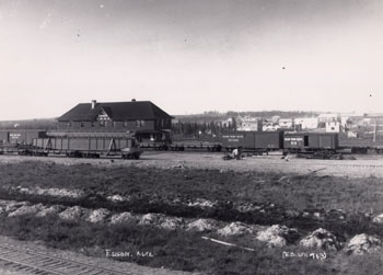
-
Article
Elbow
The first settlers appear to have been ranchers. By 1903 settlers were taking up homesteads near Elbow, and by the end of the decade lands in the elbow were extensively occupied. The CANADIAN PACIFIC RAILWAY, which arrived in 1908, has accounted for the continued existence of the village.
"https://development.thecanadianencyclopedia.ca/images/tce_placeholder.jpg?v=e9dca980c9bdb3aa11e832e7ea94f5d9" // resources/views/front/categories/view.blade.php
https://development.thecanadianencyclopedia.ca/images/tce_placeholder.jpg?v=e9dca980c9bdb3aa11e832e7ea94f5d9
-
Article
Elora
Elora, Ont, Unincorporated Place. Elora is a picturesque community located about 25 km northeast of Guelph at the junction of the Grand and Irvine rivers.
"https://development.thecanadianencyclopedia.ca/images/tce_placeholder.jpg?v=e9dca980c9bdb3aa11e832e7ea94f5d9" // resources/views/front/categories/view.blade.php
https://development.thecanadianencyclopedia.ca/images/tce_placeholder.jpg?v=e9dca980c9bdb3aa11e832e7ea94f5d9
-
Article
Elsa
In 1946 Keno Mining Co Ltd (later United Keno Hills Mines Ltd) reopened the mine. The community received a post office in 1949 and the 1950s was the starting point for the first oil exploration winter road to drilling sites 500 km to the north.
"https://development.thecanadianencyclopedia.ca/images/tce_placeholder.jpg?v=e9dca980c9bdb3aa11e832e7ea94f5d9" // resources/views/front/categories/view.blade.php
https://development.thecanadianencyclopedia.ca/images/tce_placeholder.jpg?v=e9dca980c9bdb3aa11e832e7ea94f5d9
-
Article
Esterhazy
Esterhazy, Sask, incorporated as a village in 1903 and as a town in 1957, population 2472 (2011c), 2336 (2006c). The Town of Esterhazy is located in east-central Saskatchewan, 83 km southeast of YORKTON. It is named after Count
"https://development.thecanadianencyclopedia.ca/images/tce_placeholder.jpg?v=e9dca980c9bdb3aa11e832e7ea94f5d9" // resources/views/front/categories/view.blade.php
https://development.thecanadianencyclopedia.ca/images/tce_placeholder.jpg?v=e9dca980c9bdb3aa11e832e7ea94f5d9
-
Article
Falher
Falher, Alberta, incorporated as a village in 1923 and as a town in 1955, population 1,047 (2016 census), 1,075 (2011 census). The Town of Falher is located south of Peace River. It was named for Father Constant Falher, a Roman Catholic priest.
"https://d2ttikhf7xbzbs.cloudfront.net/media/media/a3fa5c75-39d0-45e6-8260-5d27e1e63d3c.jpg" // resources/views/front/categories/view.blade.php
https://d2ttikhf7xbzbs.cloudfront.net/media/media/a3fa5c75-39d0-45e6-8260-5d27e1e63d3c.jpg
-
Article
Fort Assiniboine
Fort Assiniboine, Alta, Unincorporated Place. Fort Assiniboine is located at the confluence of the Freeman and Athabasca rivers, 150 km northwest of Edmonton. There may have been earlier posts in the area, but the first documented FUR TRADE site was Fort Assiniboine, established in 1823-24.
"https://development.thecanadianencyclopedia.ca/images/tce_placeholder.jpg?v=e9dca980c9bdb3aa11e832e7ea94f5d9" // resources/views/front/categories/view.blade.php
https://development.thecanadianencyclopedia.ca/images/tce_placeholder.jpg?v=e9dca980c9bdb3aa11e832e7ea94f5d9
-
Article
Fort Chipewyan
Fort Chipewyan, Alta, Unincorporated Place, population 847 (2011c), 756(2006c). The community of Fort Chipewyan was established for the NORTH WEST CO in 1788 by Roderick Mackenzie, cousin of Alexander MACKENZIE.
"https://d2ttikhf7xbzbs.cloudfront.net/media/media/976a3aea-8ae7-4344-b07d-ab184befc974.jpg" // resources/views/front/categories/view.blade.php
https://d2ttikhf7xbzbs.cloudfront.net/media/media/976a3aea-8ae7-4344-b07d-ab184befc974.jpg
-
Article
Fort Good Hope
Fort Good Hope, NWT, incorporated as a charter community in 1995, population 515 (2011c), 557 (2006c).
"https://d2ttikhf7xbzbs.cloudfront.net/media/media/1f4ae5ba-ddad-4d14-bd8f-f108e98c30af.jpg" // resources/views/front/categories/view.blade.php
https://d2ttikhf7xbzbs.cloudfront.net/media/media/1f4ae5ba-ddad-4d14-bd8f-f108e98c30af.jpg
-
Article
Fort Liard
Fort Liard, NWT, incorporated as a hamlet in 1987, population 536 (2011c), 583 (2006c). The Hamlet of Fort Liard is located on the south bank of the Liard River, 544 km by air southwest of Yellowknife and about 25 km north of the BC border.
"https://development.thecanadianencyclopedia.ca/images/tce_placeholder.jpg?v=e9dca980c9bdb3aa11e832e7ea94f5d9" // resources/views/front/categories/view.blade.php
https://development.thecanadianencyclopedia.ca/images/tce_placeholder.jpg?v=e9dca980c9bdb3aa11e832e7ea94f5d9
-
Article
Fort McPherson
Fort McPherson, Northwest Territories, population 647 (2021). The hamlet of Fort McPherson is located on the right bank of the Peel River, on the Dempster Highway. It is west of the Mackenzie River and east of the Richardson Mountains. Fort McPherson is called Teetł’it Zheh (“head of the waters-town”) in Gwich’in, an Athapaskan language (see Indigenous Languages in Canada). The hamlet is home to the Teetł’it Gwich’in First Nation (“people of the headwaters”). Fort McPherson is one of four communities in the Gwich’in Settlement Region. The region is an area created by the Gwich’in Comprehensive Land Claim Agreement (1992). The other three communities in the region are Aklavik, Tsiigehtchic and Inuvik.
"https://d2ttikhf7xbzbs.cloudfront.net/media/new_article_images/FortMcPherson/FortMcPhersonDog.jpg" // resources/views/front/categories/view.blade.php
https://d2ttikhf7xbzbs.cloudfront.net/media/new_article_images/FortMcPherson/FortMcPhersonDog.jpg
-
Article
Fort Providence
Fort Providence, NWT, incorporated as a hamlet in 1987, population 734 (2011c), 727 (2006c). The Hamlet of Fort Providence is located on the northeast bank of the MACKENZIE RIVER, 233 km southwest of YELLOWKNIFE.
"https://development.thecanadianencyclopedia.ca/images/tce_placeholder.jpg?v=e9dca980c9bdb3aa11e832e7ea94f5d9" // resources/views/front/categories/view.blade.php
https://development.thecanadianencyclopedia.ca/images/tce_placeholder.jpg?v=e9dca980c9bdb3aa11e832e7ea94f5d9
-
Article
Fort Resolution
Fort Resolution, NWT, incorporated as a hamlet in 2010, population 474 (2011c), 484 (2006c). The Hamlet of Fort Resolution is located on the south shore of GREAT SLAVE LAKE, 153 air km south of Yellowknife.
"https://development.thecanadianencyclopedia.ca/images/tce_placeholder.jpg?v=e9dca980c9bdb3aa11e832e7ea94f5d9" // resources/views/front/categories/view.blade.php
https://development.thecanadianencyclopedia.ca/images/tce_placeholder.jpg?v=e9dca980c9bdb3aa11e832e7ea94f5d9
-
Article
Fort Simpson
Fort Simpson, Northwest Territories (NWT), incorporated as a village in 1973, population 1,202 (2016 census), 1,238 (2011 census). The Hamlet of Fort Simpson is located on an island at the confluence of the Mackenzie and Liard rivers, 378 air km southwest of Yellowknife.
"https://d2ttikhf7xbzbs.cloudfront.net/media/media/4f133fe0-0529-435c-859e-7fc144a682c6.jpg" // resources/views/front/categories/view.blade.php
https://d2ttikhf7xbzbs.cloudfront.net/media/media/4f133fe0-0529-435c-859e-7fc144a682c6.jpg
-
Article
Fort St James
Fort St James, BC, incorporated as a village in 1952 and as a district municipality in 1995, population 1691 (2011c), 1350 (2006c). The District of Fort St James is located in central British Columbia on the southeast shore of Stuart Lake, 50 km north of VANDERHOOF.
"https://development.thecanadianencyclopedia.ca/images/tce_placeholder.jpg?v=e9dca980c9bdb3aa11e832e7ea94f5d9" // resources/views/front/categories/view.blade.php
https://development.thecanadianencyclopedia.ca/images/tce_placeholder.jpg?v=e9dca980c9bdb3aa11e832e7ea94f5d9