Browse "Villages"
-
Article
Kangiqsualujjuaq
A Hudson's Bay Company's trading post operated intermittently in the area from 1838 to 1952. A sawmill near the trading post attracted a permanent population, and the establishment of an arctic CHAR fishing co-operative in 1959 cemented the community's existence.
"https://d2ttikhf7xbzbs.cloudfront.net/media/media/2ddd79fe-a676-4b02-976a-d5c5001ed6a2.jpg" // resources/views/front/categories/view.blade.php
https://d2ttikhf7xbzbs.cloudfront.net/media/media/2ddd79fe-a676-4b02-976a-d5c5001ed6a2.jpg
-
Article
Kaslo
Kaslo, BC, incorporated as a village in 1959, population 1026 (2011c), 1072 (2006c). The Village of Kaslo is located 70 km north of Nelson, overlooking KOOTENAY LAKE. It was established in 1892 to service the silver-mining boom sweeping the Kootenays. The origin of the name is unclear.
"https://development.thecanadianencyclopedia.ca/images/tce_placeholder.jpg?v=e9dca980c9bdb3aa11e832e7ea94f5d9" // resources/views/front/categories/view.blade.php
https://development.thecanadianencyclopedia.ca/images/tce_placeholder.jpg?v=e9dca980c9bdb3aa11e832e7ea94f5d9
-
Article
Kedgwick
Kedgwick, NB, incorporated as a village in 1966, population 993 (2011c), 1146 (2006c). The Village of Kedgwick is a francophone community located 74 km southwest of CAMPBELLTON.
"https://development.thecanadianencyclopedia.ca/images/tce_placeholder.jpg?v=e9dca980c9bdb3aa11e832e7ea94f5d9" // resources/views/front/categories/view.blade.php
https://development.thecanadianencyclopedia.ca/images/tce_placeholder.jpg?v=e9dca980c9bdb3aa11e832e7ea94f5d9
-
Article
Keremeos
Keremeos, BC, incorporated as a village in 1956, population 1330 (2011c), 1289 (2006c). The Village of Keremeos is located in the fertile bench beside the Similkameen River, 45 km south of PENTICTON. Its name likely derives from a Salish phrase meaning "wind channel in the mountain.
"https://development.thecanadianencyclopedia.ca/images/tce_placeholder.jpg?v=e9dca980c9bdb3aa11e832e7ea94f5d9" // resources/views/front/categories/view.blade.php
https://development.thecanadianencyclopedia.ca/images/tce_placeholder.jpg?v=e9dca980c9bdb3aa11e832e7ea94f5d9
-
Article
Killarney (Man)
Killarney, Manitoba, population centre, population 2197 (2011c), 2273 (2006c). Killarney was incorporated as a village in 1903, as a town in 1907 and merged with the Rural Municipality of Turtle Mountain to form the Municipality of Killarney-Turtle Mountain in 2007.
"https://development.thecanadianencyclopedia.ca/images/tce_placeholder.jpg?v=e9dca980c9bdb3aa11e832e7ea94f5d9" // resources/views/front/categories/view.blade.php
https://development.thecanadianencyclopedia.ca/images/tce_placeholder.jpg?v=e9dca980c9bdb3aa11e832e7ea94f5d9
-
Article
Kimmirut
Kimmirut, Nunavut, incorporated as a hamlet in 1982, population 455 (2011c), 411 (2006c). The Hamlet of Kimmirut is located on the south coast of Baffin Island, approximately 120 km southwest of Iqaluit.
"https://development.thecanadianencyclopedia.ca/images/tce_placeholder.jpg?v=e9dca980c9bdb3aa11e832e7ea94f5d9" // resources/views/front/categories/view.blade.php
https://development.thecanadianencyclopedia.ca/images/tce_placeholder.jpg?v=e9dca980c9bdb3aa11e832e7ea94f5d9
-
Article
Ksan
Ksan (or ‘Ksan) is a historical village, museum and campground, owned and operated by the Gitanmaax Band. It is located at the junction of the Skeena and Bulkley rivers in Hazelton, British Columbia. Ksan was established in 1970 as way to promote and preserve Gitxsan culture and history.
"https://d2ttikhf7xbzbs.cloudfront.net/media/media/2fd73ae3-5ed7-4894-b6ae-caa2ac25e639.jpg" // resources/views/front/categories/view.blade.php
https://d2ttikhf7xbzbs.cloudfront.net/media/media/2fd73ae3-5ed7-4894-b6ae-caa2ac25e639.jpg
-
Article
Kugaaruk
Kugaaruk, Nunavut, incorporated as a hamlet in 1972, population 771 (2011c), 688 (2006c). The Hamlet of Kugaaruk is located in the northeastern Arctic on the coast within Pelly Bay
"https://development.thecanadianencyclopedia.ca/images/tce_placeholder.jpg?v=e9dca980c9bdb3aa11e832e7ea94f5d9" // resources/views/front/categories/view.blade.php
https://development.thecanadianencyclopedia.ca/images/tce_placeholder.jpg?v=e9dca980c9bdb3aa11e832e7ea94f5d9
-
Article
Kugluktuk
Kugluktuk, Nunavut, incorporated as a hamlet in 1981, population 1,491 (2016 census), population 1,450 (2011 census). The Hamlet of Kugluktuk, formerly known as Coppermine, is situated west of the mouth of the Coppermine River on the mainland Arctic coast. The hamlet changed its name in 1996 to Kugluktuk, which means "place of rapids," referring to the rapids at Bloody Falls, 15 km upstream.
"https://development.thecanadianencyclopedia.ca/images/tce_placeholder.jpg?v=e9dca980c9bdb3aa11e832e7ea94f5d9" // resources/views/front/categories/view.blade.php
https://development.thecanadianencyclopedia.ca/images/tce_placeholder.jpg?v=e9dca980c9bdb3aa11e832e7ea94f5d9
-
Article
La Loche
The NORTH WEST COMPANY had a post at the Portage as early as 1808 and the HUDSON'S BAY COMPANY soon followed suit. Here the Athabasca and Mackenzie River brigades exchanged goods and furs with the La Loche brigade.
"https://development.thecanadianencyclopedia.ca/images/tce_placeholder.jpg?v=e9dca980c9bdb3aa11e832e7ea94f5d9" // resources/views/front/categories/view.blade.php
https://development.thecanadianencyclopedia.ca/images/tce_placeholder.jpg?v=e9dca980c9bdb3aa11e832e7ea94f5d9
-
Article
Lytton
Lytton, British Columbia, incorporated as a village in 1945, population 249 (2016 census), 228 (2011 census). The village of Lytton is located on the Trans-Canada Highway, 260 km northeast of Vancouver, at the junction of the Thompson and Fraser rivers. This is one of the driest and warmest spots in Canada.
"https://d2ttikhf7xbzbs.cloudfront.net/media/media/597fe6e1-a416-4a06-8227-f84345c5562b.jpg" // resources/views/front/categories/view.blade.php
https://d2ttikhf7xbzbs.cloudfront.net/media/media/597fe6e1-a416-4a06-8227-f84345c5562b.jpg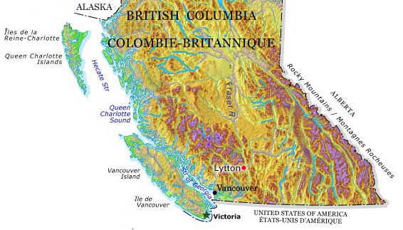
-
Article
Manning
Manning, Alta, incorporated as a village in 1951 and as a town in 1957, population 1164 (2011c), 1493 (2006c). The Town of Manning lies beside the Notikewin River, 73 km north of the town of PEACE RIVER.
"https://development.thecanadianencyclopedia.ca/images/tce_placeholder.jpg?v=e9dca980c9bdb3aa11e832e7ea94f5d9" // resources/views/front/categories/view.blade.php
https://development.thecanadianencyclopedia.ca/images/tce_placeholder.jpg?v=e9dca980c9bdb3aa11e832e7ea94f5d9
-
Article
Marshall
Marshall, Sask, incorporated as a village in 1914 and as a town in 2006, population 533 (2011c), 608 (2006c). The Town of Marshall is located on the Canadian National Railway line and the Yellowhead Highway between LLOYDMINSTER and NORTH BATTLEFORD, in the Rural Municipality of WILTON.
"https://development.thecanadianencyclopedia.ca/images/tce_placeholder.jpg?v=e9dca980c9bdb3aa11e832e7ea94f5d9" // resources/views/front/categories/view.blade.php
https://development.thecanadianencyclopedia.ca/images/tce_placeholder.jpg?v=e9dca980c9bdb3aa11e832e7ea94f5d9
-
Article
Masset
Masset, BC, incorporated as a village in 1961, population 884 (2011c), 940 (2006c). The Village of Masset is located on the northern tip of Graham Island, the largest of HAIDA GWAII off the northern coast of British Columbia.
"https://development.thecanadianencyclopedia.ca/images/tce_placeholder.jpg?v=e9dca980c9bdb3aa11e832e7ea94f5d9" // resources/views/front/categories/view.blade.php
https://development.thecanadianencyclopedia.ca/images/tce_placeholder.jpg?v=e9dca980c9bdb3aa11e832e7ea94f5d9
-
Article
Mayo
In 1919 the discovery of silver-lead deposits at KENO HILL transformed Mayo into a major transshipment point for ore. In 1950 a road was built to the Klondike Highway, but as the riverboats went out of service, Mayo declined.
"https://development.thecanadianencyclopedia.ca/images/tce_placeholder.jpg?v=e9dca980c9bdb3aa11e832e7ea94f5d9" // resources/views/front/categories/view.blade.php
https://development.thecanadianencyclopedia.ca/images/tce_placeholder.jpg?v=e9dca980c9bdb3aa11e832e7ea94f5d9