Browse "Villages"
-
Article
McAdam
McAdam, NB, incorporated as a village in1966, population 1284 (2011c), 1404 (2006c). The Village of McAdam is located in York County, in the Appalachian Highlands region of southwestern New Brunswick, 10 km from the Canada/US border.
"https://development.thecanadianencyclopedia.ca/images/tce_placeholder.jpg?v=e9dca980c9bdb3aa11e832e7ea94f5d9" // resources/views/front/categories/view.blade.php
https://development.thecanadianencyclopedia.ca/images/tce_placeholder.jpg?v=e9dca980c9bdb3aa11e832e7ea94f5d9
-
Article
Merrickville-Wolford
Merrickville-Wolford, Ont, incorporated as a village in 1998, population 2850 (2011c), 2867 (2006c). The Village of Merrickville-Wolford is located on the Rideau River, 55 km southwest of Ottawa.
"https://development.thecanadianencyclopedia.ca/images/tce_placeholder.jpg?v=e9dca980c9bdb3aa11e832e7ea94f5d9" // resources/views/front/categories/view.blade.php
https://development.thecanadianencyclopedia.ca/images/tce_placeholder.jpg?v=e9dca980c9bdb3aa11e832e7ea94f5d9
-
Article
Minto
Minto, NB, incorporated as a village in1962, population 2505 (2011c), 2681 (2006c). It is located 56 km north of Fredericton in the Minto coalfields.
"https://development.thecanadianencyclopedia.ca/images/tce_placeholder.jpg?v=e9dca980c9bdb3aa11e832e7ea94f5d9" // resources/views/front/categories/view.blade.php
https://development.thecanadianencyclopedia.ca/images/tce_placeholder.jpg?v=e9dca980c9bdb3aa11e832e7ea94f5d9
-
Article
Montrose
Montrose, BC, incorporated as a village in 1956, population 1030 (2011c), 1012 (2006c). The Village of Montrose is located in the West Kootenay district of southeastern British Columbia.
"https://development.thecanadianencyclopedia.ca/images/tce_placeholder.jpg?v=e9dca980c9bdb3aa11e832e7ea94f5d9" // resources/views/front/categories/view.blade.php
https://development.thecanadianencyclopedia.ca/images/tce_placeholder.jpg?v=e9dca980c9bdb3aa11e832e7ea94f5d9
-
Article
Nakusp
Nakusp, British Columbia, incorporated as a village in 1964, population 1,605 (2016 census), 1,569 (2011 census). The village of Nakusp is located on the east shore of Upper Arrow Lake at the foot of the Selkirk Mountains. It is in the West Kootenay district of south-eastern British Columbia. Nakusp is located on the traditional territory of the Sinixt, Ktunaxa, Secwepemc and Okanagan peoples. (See also Interior Salish.) The name is derived from a Sinixt word, though its meaning is debated. One interpretation is that the name Nakusp comes from a word meaning “the bay behind the long point,” another is that it means, “closed-in” or “safe.”
"https://development.thecanadianencyclopedia.ca/images/tce_placeholder.jpg?v=e9dca980c9bdb3aa11e832e7ea94f5d9" // resources/views/front/categories/view.blade.php
https://development.thecanadianencyclopedia.ca/images/tce_placeholder.jpg?v=e9dca980c9bdb3aa11e832e7ea94f5d9
-
Article
Neguac
Neguac, NB, incorporated as a village in 1967, population 1678 (2011c), 1623 (2006c). The Village of Neguac is located in northeast New Brunswick near the head of Miramichi Bay, 41 km northeast of Miramichi.
"https://d2ttikhf7xbzbs.cloudfront.net/media/media/916d6c3d-9da2-4e33-bdc6-70bb07dfa1b5.jpg" // resources/views/front/categories/view.blade.php
https://d2ttikhf7xbzbs.cloudfront.net/media/media/916d6c3d-9da2-4e33-bdc6-70bb07dfa1b5.jpg
-
Article
New Denver
New Denver, British Columbia, incorporated as a village in 1929, population 473 (2016 census), 504 (2011 census). The village of New Denver is located near the northeastern end of Slocan Lake, 100 km north of Nelson. The site was first called Eldorado, then New Denver (1892), after Denver, Colorado.
"https://development.thecanadianencyclopedia.ca/images/tce_placeholder.jpg?v=e9dca980c9bdb3aa11e832e7ea94f5d9" // resources/views/front/categories/view.blade.php
https://development.thecanadianencyclopedia.ca/images/tce_placeholder.jpg?v=e9dca980c9bdb3aa11e832e7ea94f5d9
-
Article
New Maryland
New Maryland includes a number of historic buildings, including the Anglican church and Victoria Hall. It was the site of the last fatal duel in the province in 1821.
"https://d2ttikhf7xbzbs.cloudfront.net/media/media/d2d9fbdd-77c8-46bf-80c4-6ebaf8dab8e0.jpg" // resources/views/front/categories/view.blade.php
https://d2ttikhf7xbzbs.cloudfront.net/media/media/d2d9fbdd-77c8-46bf-80c4-6ebaf8dab8e0.jpg
-
Article
Notre Dame de Lourdes
Notre Dame de Lourdes, Manitoba, incorporated as a village in 1963, population 683 (2011c), 589 (2006c). The Village of Notre Dame de Lourdes is situated on the northeast slope of the Pembina Hills, 130 km southwest of WINNIPEG.
"https://development.thecanadianencyclopedia.ca/images/tce_placeholder.jpg?v=e9dca980c9bdb3aa11e832e7ea94f5d9" // resources/views/front/categories/view.blade.php
https://development.thecanadianencyclopedia.ca/images/tce_placeholder.jpg?v=e9dca980c9bdb3aa11e832e7ea94f5d9
-
Article
Petit Rocher
Petit Rocher, NB, incorporated as a village in 1966, population 1908 (2011c), 1949 (2006c). The Village of Petit Rocher is located on Chaleur Bay near BATHURST.
"https://d2ttikhf7xbzbs.cloudfront.net/media/media/f4d5838c-a5b8-41dd-968f-8704190af9c1.jpg" // resources/views/front/categories/view.blade.php
https://d2ttikhf7xbzbs.cloudfront.net/media/media/f4d5838c-a5b8-41dd-968f-8704190af9c1.jpg
-
Article
Pouce Coupe
Pouce Coupe, British Columbia, incorporated as a village in 1932, population 792 (2016 census), 738 (2011 census). The village of Pouce Coupe is located 6 km southeast of Dawson Creek on the highway and freight railway between there and Grande Prairie, Alberta. Its name likely comes from that of a Dane-zaa chief, Pooscapee, which early voyageurs rendered into the French name Pouce Coupé (Cut Thumb).
"https://development.thecanadianencyclopedia.ca/images/tce_placeholder.jpg?v=e9dca980c9bdb3aa11e832e7ea94f5d9" // resources/views/front/categories/view.blade.php
https://development.thecanadianencyclopedia.ca/images/tce_placeholder.jpg?v=e9dca980c9bdb3aa11e832e7ea94f5d9
-
Article
Prud'homme
Prud'homme, Saskatchewan, incorporated as a village in 1922, population 167 (2016 census), 172 (2011 census). The village of Prud'homme is located about 45 km northeast of Saskatoon. Prud'homme is the hometown of Jeanne Sauvé, a former cabinet minister in the Pierre Trudeau government, the first woman to hold the position of Speaker of the House of Commons and the first woman to act as Governor General of Canada.
"https://development.thecanadianencyclopedia.ca/images/tce_placeholder.jpg?v=e9dca980c9bdb3aa11e832e7ea94f5d9" // resources/views/front/categories/view.blade.php
https://development.thecanadianencyclopedia.ca/images/tce_placeholder.jpg?v=e9dca980c9bdb3aa11e832e7ea94f5d9
-
Article
Pugwash
Pugwash, NS, incorporated as a village in 1948, population 744 (2011c), 784 (2006c). Pugwash is located 65 km northwest of TRURO, at the mouth of the Pugwash River.
"https://development.thecanadianencyclopedia.ca/images/tce_placeholder.jpg?v=e9dca980c9bdb3aa11e832e7ea94f5d9" // resources/views/front/categories/view.blade.php
https://development.thecanadianencyclopedia.ca/images/tce_placeholder.jpg?v=e9dca980c9bdb3aa11e832e7ea94f5d9
-
Article
Rexton
Rexton, NB, incorporated as a village in 1966, population 818 (2011c), 862 (2006c). The Village of Rexton is located in southeastern New Brunswick, at the mouth of the Richibucto River.
"https://development.thecanadianencyclopedia.ca/images/tce_placeholder.jpg?v=e9dca980c9bdb3aa11e832e7ea94f5d9" // resources/views/front/categories/view.blade.php
https://development.thecanadianencyclopedia.ca/images/tce_placeholder.jpg?v=e9dca980c9bdb3aa11e832e7ea94f5d9
-
Article
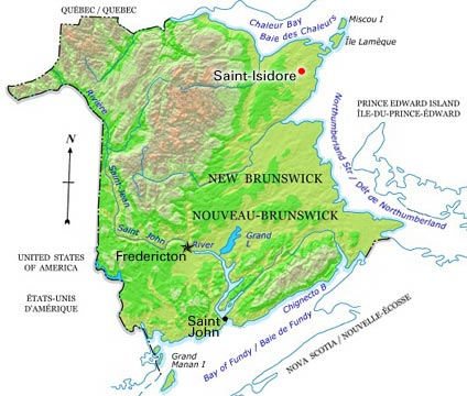
Saint-Isidore
Saint-Isidore, NB, incorporated as a village in 1991, population 748 (2011c), 796 (2006c). The Village of Saint-Isidore is located about 10 km inland on the northeastern tip of New Brunswick, 15 km east of TRACADIE-SHEILA.
"https://d2ttikhf7xbzbs.cloudfront.net/media/media/01b36516-3316-4622-9ac7-1426d02b2427.jpg" // resources/views/front/categories/view.blade.php
https://d2ttikhf7xbzbs.cloudfront.net/media/media/01b36516-3316-4622-9ac7-1426d02b2427.jpg