Browse "Coastal Regions"
-
Article
Cape Sable
Cape Sable is the southernmost point of land on CAPE SABLE ISLAND, which lies off the southwestern tip of Nova Scotia. It is composed of shifting sand dunes (French, sable) up to 9 m high and is nearly joined to the island by a sandy beach transversed by Hawk Channel.
"https://development.thecanadianencyclopedia.ca/images/tce_placeholder.jpg?v=e9dca980c9bdb3aa11e832e7ea94f5d9" // resources/views/front/categories/view.blade.php
https://development.thecanadianencyclopedia.ca/images/tce_placeholder.jpg?v=e9dca980c9bdb3aa11e832e7ea94f5d9
-
Article
Cape Spear
Cape Spear, elev 75 m, most easterly point in N America (excluding Greenland), is located 6.7 km SE of the entrance to St John's harbour, Nfld. A rocky, windswept promontory of Precambrian formation, with a thin, sporadic cover
"https://d2ttikhf7xbzbs.cloudfront.net/media/media/907c73d8-6d3f-45cf-a339-1e12575cd24a.jpg" // resources/views/front/categories/view.blade.php
https://d2ttikhf7xbzbs.cloudfront.net/media/media/907c73d8-6d3f-45cf-a339-1e12575cd24a.jpg
-
Article
Cape St Mary
Cape St Mary forms the southern boundary of St Mary's Bay in an area of Nova Scotia's northwestern coast known as the French Shore. Fishing is the principal activity in this region; the cape was once the site of the International Tuna Cup matches.
"https://development.thecanadianencyclopedia.ca/images/tce_placeholder.jpg?v=e9dca980c9bdb3aa11e832e7ea94f5d9" // resources/views/front/categories/view.blade.php
https://development.thecanadianencyclopedia.ca/images/tce_placeholder.jpg?v=e9dca980c9bdb3aa11e832e7ea94f5d9
-
Article
Cape St Mary's
Cape St Mary's, elevation 105 m, on Newfoundland's AVALON PENINSULA, is the steep and spectacular terminus of the land separating ST MARY'S BAY and PLACENTIA BAY near rich fishing grounds. The site of a lighthouse since 1860, the
"https://development.thecanadianencyclopedia.ca/images/tce_placeholder.jpg?v=e9dca980c9bdb3aa11e832e7ea94f5d9" // resources/views/front/categories/view.blade.php
https://development.thecanadianencyclopedia.ca/images/tce_placeholder.jpg?v=e9dca980c9bdb3aa11e832e7ea94f5d9
-
Article
Cedar Dunes Provincial Park
Tucked into the westernmost corner of Prince Edward Island, Cedar Dunes Provincial Park (established 1962, 37 ha) has been developed around an historic lighthouse. Known as West Point, the site is the result of centuries of accretion of sand from a north to south coastal current.
"https://development.thecanadianencyclopedia.ca/images/tce_placeholder.jpg?v=e9dca980c9bdb3aa11e832e7ea94f5d9" // resources/views/front/categories/view.blade.php
https://development.thecanadianencyclopedia.ca/images/tce_placeholder.jpg?v=e9dca980c9bdb3aa11e832e7ea94f5d9
-
Article
Chaleur Bay
Chaleur Bay, which lies between the Gaspé Peninsula, Québec, and northern New Brunswick, is the largest bay in the Gulf of St Lawrence. At its entrance lies Miscou Island.
"https://development.thecanadianencyclopedia.ca/images/tce_placeholder.jpg?v=e9dca980c9bdb3aa11e832e7ea94f5d9" // resources/views/front/categories/view.blade.php
https://development.thecanadianencyclopedia.ca/images/tce_placeholder.jpg?v=e9dca980c9bdb3aa11e832e7ea94f5d9
-
Article
Chignecto Bay
Chignecto Bay, northeastern arm of the Bay of Fundy. The name comes from the Indigenous word sigunikt, usually said to mean "foot cloth," perhaps from a Mi'kmaq legend. The area around present-day Sackville, NB, was first settled by Acadians in 1671 and by Yorkshire Methodists about 100 years later.
"https://development.thecanadianencyclopedia.ca/images/tce_placeholder.jpg?v=e9dca980c9bdb3aa11e832e7ea94f5d9" // resources/views/front/categories/view.blade.php
https://development.thecanadianencyclopedia.ca/images/tce_placeholder.jpg?v=e9dca980c9bdb3aa11e832e7ea94f5d9
-
Article
Clayoquot Sound
Clayoquot Sound is a dramatically varied inlet of the Pacific Ocean nearly 100 km wide on the west coast of Vancouver Island (estimated area, water 784.25 km2; land including freshwater 2715.75 km2 ). Clayoquot ("clah quat") Sound takes in the highly scenic islands and mainland drainages from Quisitis Point northwest to Escalante Point. Population is concentrated at Tofino, a fishing, tourism and wilderness recreation centre at the terminus of Highway 4. Most Indigenous communities are accessible only by air or water.
"https://d2ttikhf7xbzbs.cloudfront.net/media/media/90cececc-c640-4ea8-bfdc-87f67c45f230.jpg" // resources/views/front/categories/view.blade.php
https://d2ttikhf7xbzbs.cloudfront.net/media/media/90cececc-c640-4ea8-bfdc-87f67c45f230.jpg
-
Article
Conception Bay
Conception Bay is one of the principal bays of Newfoundland, formed by 2 north-reaching arms of the Avalon Peninsula.
"https://d2ttikhf7xbzbs.cloudfront.net/media/media/10880883-dae5-469a-b120-3fae8e4d17c2.jpg" // resources/views/front/categories/view.blade.php
https://d2ttikhf7xbzbs.cloudfront.net/media/media/10880883-dae5-469a-b120-3fae8e4d17c2.jpg
-
Article
Coronation Gulf
Coronation Gulf is a broad indentation in the arctic shore of the territory of Nunavut, roughly the shape of the south coast of Victoria Island, which lies directly north.
"https://d2ttikhf7xbzbs.cloudfront.net/media/media/b504d03a-1419-4bf4-ab27-00b5e8cc89a0.jpg" // resources/views/front/categories/view.blade.php
https://d2ttikhf7xbzbs.cloudfront.net/media/media/b504d03a-1419-4bf4-ab27-00b5e8cc89a0.jpg
-
Article
Cumberland Sound
Cumberland Sound is a major inlet, 300 km long, with an average width of 65 km, in the east coast of BAFFIN ISLAND. Its steep sides rise over 2125 m to glacier-covered uplands.
"https://development.thecanadianencyclopedia.ca/images/tce_placeholder.jpg?v=e9dca980c9bdb3aa11e832e7ea94f5d9" // resources/views/front/categories/view.blade.php
https://development.thecanadianencyclopedia.ca/images/tce_placeholder.jpg?v=e9dca980c9bdb3aa11e832e7ea94f5d9
-
Article
Dark Harbour
Dark Harbour, located on the west side of GRAND MANAN ISLAND, New Brunswick, is the only suitable haven for fishing craft along the island's western shore, which is dominated by high cliffs. It is relatively isolated from the communities on the more hospitable eastern side facing the Bay of Fundy.
"https://development.thecanadianencyclopedia.ca/images/tce_placeholder.jpg?v=e9dca980c9bdb3aa11e832e7ea94f5d9" // resources/views/front/categories/view.blade.php
https://development.thecanadianencyclopedia.ca/images/tce_placeholder.jpg?v=e9dca980c9bdb3aa11e832e7ea94f5d9
-
Article
Davis Strait
Some of the greatest depths in the eastern Arctic are reached here (3660 m) in the southern end of the strait. The surface waters are strongly affected by counterclockwise-flowing currents.
"https://d2ttikhf7xbzbs.cloudfront.net/media/media/9669519f-2a3e-42ad-83f1-b803cd3cf07b.jpg" // resources/views/front/categories/view.blade.php
https://d2ttikhf7xbzbs.cloudfront.net/media/media/9669519f-2a3e-42ad-83f1-b803cd3cf07b.jpg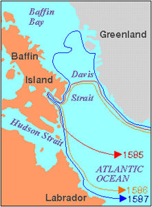
-
Article
Dixon Entrance
Dixon Entrance is a strait between Haida Gwaii on the north coast of British Columbia and Prince of Wales and Dall islands in Alaska.
"https://development.thecanadianencyclopedia.ca/images/tce_placeholder.jpg?v=e9dca980c9bdb3aa11e832e7ea94f5d9" // resources/views/front/categories/view.blade.php
https://development.thecanadianencyclopedia.ca/images/tce_placeholder.jpg?v=e9dca980c9bdb3aa11e832e7ea94f5d9
-
Article
Eastmain
Eastmain (or East Main) refers to the east shore of Hudson Bay, although in the 1680s the term was restricted to the vicinity of the Eastmain River. The corresponding reference to the west shore of Hudson Bay is the Westmain (West Main).
"https://development.thecanadianencyclopedia.ca/images/tce_placeholder.jpg?v=e9dca980c9bdb3aa11e832e7ea94f5d9" // resources/views/front/categories/view.blade.php
https://development.thecanadianencyclopedia.ca/images/tce_placeholder.jpg?v=e9dca980c9bdb3aa11e832e7ea94f5d9