Browse "Places"
-
Article
Stikine Territory
Stikine Territory Between 1839 and the 1867 American purchase of Alaska, the HUDSON'S BAY COMPANY leased the continental portion of the Alaska Panhandle from the Russian American Fur Co.
"https://development.thecanadianencyclopedia.ca/images/tce_placeholder.jpg?v=e9dca980c9bdb3aa11e832e7ea94f5d9" // resources/views/front/categories/view.blade.php
https://development.thecanadianencyclopedia.ca/images/tce_placeholder.jpg?v=e9dca980c9bdb3aa11e832e7ea94f5d9
-
Article
Stonewall
Stonewall, Manitoba, incorporated as a town in 1908, population 4536 (2011c), 4376 (2006c). The Town of Stonewall is located 24 km northwest of Winnipeg on a limestone outcrop in the southern Interlake.
"https://development.thecanadianencyclopedia.ca/images/tce_placeholder.jpg?v=e9dca980c9bdb3aa11e832e7ea94f5d9" // resources/views/front/categories/view.blade.php
https://development.thecanadianencyclopedia.ca/images/tce_placeholder.jpg?v=e9dca980c9bdb3aa11e832e7ea94f5d9
-
Article
Stoney Creek
The first European settlers, primarily LOYALISTS, arrived from the US in 1786. The area was cleared for mixed farming and Stoney Creek attracted many saw and grain mills and other agricultural service activities.
"https://development.thecanadianencyclopedia.ca/images/tce_placeholder.jpg?v=e9dca980c9bdb3aa11e832e7ea94f5d9" // resources/views/front/categories/view.blade.php
https://development.thecanadianencyclopedia.ca/images/tce_placeholder.jpg?v=e9dca980c9bdb3aa11e832e7ea94f5d9
-
Article
Stony Plain
Stony Plain, Alta, incorporated as a town in 1908, population 15 051 (2011c), 12 363 (2006c). The Town of Stony Plain is located about 25 km west of EDMONTON. Settlement began in 1881 about 3 km south of the present town. This settlement was called Dogrump Creek but in 1892 was renamed Stony Plain.
"https://development.thecanadianencyclopedia.ca/images/tce_placeholder.jpg?v=e9dca980c9bdb3aa11e832e7ea94f5d9" // resources/views/front/categories/view.blade.php
https://development.thecanadianencyclopedia.ca/images/tce_placeholder.jpg?v=e9dca980c9bdb3aa11e832e7ea94f5d9
-
Article
Stornoway
Stornoway is the official residence of Canada’s federal leader of the Opposition. It is located at 541 Acacia Ave in the village of Rockcliffe Park in Ottawa. Purchased in 1950 by a private trust, Stornoway has been owned by the Government of Canada since 1970 and managed by the National Capital Commission since 1986.
"https://d2ttikhf7xbzbs.cloudfront.net/media/media/d2b6590d-341d-4404-9720-e10d3b91116b.jpg" // resources/views/front/categories/view.blade.php
https://d2ttikhf7xbzbs.cloudfront.net/media/media/d2b6590d-341d-4404-9720-e10d3b91116b.jpg
-
Article
Strait of Anian
Strait of Anian, part of the legendary Northwest Passage linking the Atlantic and Pacific oceans, likely Bering Strait.
"https://d2ttikhf7xbzbs.cloudfront.net/media/media/3dba2c3d-19d5-4563-ab19-30bc1172350d.jpg" // resources/views/front/categories/view.blade.php
https://d2ttikhf7xbzbs.cloudfront.net/media/media/3dba2c3d-19d5-4563-ab19-30bc1172350d.jpg
-
Article
Strait of Canso
Strait of Canso of, 27 km long, 3 km wide, 60 m deep, is a deep, narrow channel separating the Nova Scotian mainland and Cape Breton Island.
"https://development.thecanadianencyclopedia.ca/images/tce_placeholder.jpg?v=e9dca980c9bdb3aa11e832e7ea94f5d9" // resources/views/front/categories/view.blade.php
https://development.thecanadianencyclopedia.ca/images/tce_placeholder.jpg?v=e9dca980c9bdb3aa11e832e7ea94f5d9
-
Article
Strait of Georgia
The Strait of Georgia is a body of water separating Vancouver Island and mainland British Columbia south of Quadra Island.
"https://development.thecanadianencyclopedia.ca/images/tce_placeholder.jpg?v=e9dca980c9bdb3aa11e832e7ea94f5d9" // resources/views/front/categories/view.blade.php
https://development.thecanadianencyclopedia.ca/images/tce_placeholder.jpg?v=e9dca980c9bdb3aa11e832e7ea94f5d9
-
Article
Stratford
Urban growth was slow until the railway-building boom of the 1850s. Stratford businessmen lobbied for the forming in 1853 of the County of Perth, with Stratford as the county seat, and the county at once voted bonuses to railway companies.
"https://d2ttikhf7xbzbs.cloudfront.net/media/media/664057ff-dd11-4f37-abff-a514d6fb143e.jpg" // resources/views/front/categories/view.blade.php
https://d2ttikhf7xbzbs.cloudfront.net/media/media/664057ff-dd11-4f37-abff-a514d6fb143e.jpg
-
Article
Music in Stratford
Ontario town (Little Thames until 1831) located on the Avon River 75 kilometres west of Hamilton, in Perth County, and incorporated as a city in 1885. It was the site of railway shops ca. 1871-1964 and became the home of the Stratford Festival in 1953.
"https://d2ttikhf7xbzbs.cloudfront.net/media/media/664057ff-dd11-4f37-abff-a514d6fb143e.jpg" // resources/views/front/categories/view.blade.php
https://d2ttikhf7xbzbs.cloudfront.net/media/media/664057ff-dd11-4f37-abff-a514d6fb143e.jpg
-
Article
The Stratford Festival
The Stratford Festival is one of the world’s premier festivals of classical and contemporary theatre.
"https://d2ttikhf7xbzbs.cloudfront.net/media/media/3f55e2d7-595b-4ef4-820a-073c03e04942.jpg" // resources/views/front/categories/view.blade.php
https://d2ttikhf7xbzbs.cloudfront.net/media/media/3f55e2d7-595b-4ef4-820a-073c03e04942.jpg
-
Article
Strathcona Provincial Park
Strathcona Provincial Park (established 1911, 2504 km2) is a mountain wilderness in central Vancouver Island, 9 km east of Gold River and 26 km west of Campbell River.
"https://development.thecanadianencyclopedia.ca/images/tce_placeholder.jpg?v=e9dca980c9bdb3aa11e832e7ea94f5d9" // resources/views/front/categories/view.blade.php
https://development.thecanadianencyclopedia.ca/images/tce_placeholder.jpg?v=e9dca980c9bdb3aa11e832e7ea94f5d9
-
Article
Strathgartney Provincial Park
In Scots Gaelic Strath Gartney means "a valley in the hills." This description aptly fits Strathgartney Provincial Park (established 1959, 53 ha) located in the central hills of Prince Edward Island, 25 km west of CHARLOTTETOWN.
"https://development.thecanadianencyclopedia.ca/images/tce_placeholder.jpg?v=e9dca980c9bdb3aa11e832e7ea94f5d9" // resources/views/front/categories/view.blade.php
https://development.thecanadianencyclopedia.ca/images/tce_placeholder.jpg?v=e9dca980c9bdb3aa11e832e7ea94f5d9
-
Article
Strathmore
Strathmore, Alta, incorporated as a town in 1911, population 12 305 (2011c), 10 280 (2006c). The Town of Strathmore is located 40 km east of CALGARY. Strathmore was named after Charles Bowes-Lyon, 13th earl of Strathmore (1824-1904), a forefather of Queen Elizabeth II.
"https://d2ttikhf7xbzbs.cloudfront.net/media/media/210a4861-11eb-4238-97ad-3bdd221a3b60.jpg" // resources/views/front/categories/view.blade.php
https://d2ttikhf7xbzbs.cloudfront.net/media/media/210a4861-11eb-4238-97ad-3bdd221a3b60.jpg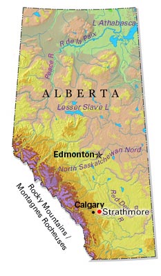
-
Article
Strathroy-Caradoc
During its early history Strathroy suffered a number of devastating fires. In 1868 a blaze wiped out a considerable portion of Strathroy's business section. Several fires in manufacturing plants in the late 1890s and an agricultural depression caused a period of economic downturn for the town.
"https://d2ttikhf7xbzbs.cloudfront.net/media/media/997b9858-a7a8-4f8a-8880-76bd7d7f9b96.jpg" // resources/views/front/categories/view.blade.php
https://d2ttikhf7xbzbs.cloudfront.net/media/media/997b9858-a7a8-4f8a-8880-76bd7d7f9b96.jpg