Browse "Places"
-
Article
Sydney
Sydney, Nova Scotia, incorporated as a city in 1900, population 30,960 (2021 census), 30,170 (2016 census). Sydney is located near the eastern extremity of Cape Breton Island. It is the centre of the second-largest urban complex in Nova Scotia, Cape Breton Regional Municipality (1995). Its fine harbour, known as Spanish Bay in colonial times, is ringed by the richest coalfield in eastern Canada. Since 1900, it has been noted for its huge steel mill, the largest and most modern in Canada at its construction. The industrial core around the mill has been in decline since the end of the Second World War as the coal mines of the surrounding communities became less productive and the obsolete steel mill less competitive with central Canadian producers.
"https://d2ttikhf7xbzbs.cloudfront.net/media/media/de26e0a9-50cb-48be-bf77-273aa9c599f6.jpg" // resources/views/front/categories/view.blade.php
https://d2ttikhf7xbzbs.cloudfront.net/media/media/de26e0a9-50cb-48be-bf77-273aa9c599f6.jpg
-
Article
Sydney Mines
Sydney Mines, NS, Urban Community, population 14 135 (2011c), 15 315 (2006c). Sydney Mines is located on the north side of Sydney Harbour, 19 km from SYDNEY.
"https://development.thecanadianencyclopedia.ca/images/tce_placeholder.jpg?v=e9dca980c9bdb3aa11e832e7ea94f5d9" // resources/views/front/categories/view.blade.php
https://development.thecanadianencyclopedia.ca/images/tce_placeholder.jpg?v=e9dca980c9bdb3aa11e832e7ea94f5d9
-
Article
Sylvan Lake
Sylvan Lake, Alberta, incorporated as a village in 1913 and as a town in 1946, population 14,816 (2016 census), 12,362 (2011 census). The town of Sylvan Lake is located on the south shore of the lake of the same name in central Alberta, approximately 20 km west of Red Deer. The origin of the name is descriptive. The area was once heavily forested and the name is based on the Latin word sylva, which means wood or forest. The lake was known variously as Snake (by the Cree and Stoney-Nakoda), and Methy or Swan (by 19th century explorers). In 1909, a local resident, Mrs. Green, circulated a petition to change the lake’s name to Sylvan Lake.
"https://d2ttikhf7xbzbs.cloudfront.net/media/media/197d9f2c-4736-4f46-970d-296cd223f411.jpg" // resources/views/front/categories/view.blade.php
https://d2ttikhf7xbzbs.cloudfront.net/media/media/197d9f2c-4736-4f46-970d-296cd223f411.jpg
-
Article
Synagogues
According to Jewish law, a synagogue is defined as any place where 10 men can gather for worship and study. Tradition holds that the synagogue was established to provide an alternative for those who were unable to travel to the temple in Jerusalem.
"https://d2ttikhf7xbzbs.cloudfront.net/media/media/3cdd3a26-f43a-47c9-a723-6bb582abdab7.jpg" // resources/views/front/categories/view.blade.php
https://d2ttikhf7xbzbs.cloudfront.net/media/media/3cdd3a26-f43a-47c9-a723-6bb582abdab7.jpg
-
Article
Taber
Taber, Alberta, incorporated as a town in 1907, population 8,428 (2016 census), 8,104 (2011 census). The town of Taber is located 50 km east of Lethbridge.
"https://development.thecanadianencyclopedia.ca/images/tce_placeholder.jpg?v=e9dca980c9bdb3aa11e832e7ea94f5d9" // resources/views/front/categories/view.blade.php
https://development.thecanadianencyclopedia.ca/images/tce_placeholder.jpg?v=e9dca980c9bdb3aa11e832e7ea94f5d9
-
Article
Tadoussac
Tadoussac, Quebec, incorporated as a village in 1899, population 799 (2016 census), 813 (2011 census). Tadoussac is located at the confluence of the Saguenay and St. Lawrence rivers, 210 km northeast of Quebec City. In the Innu language, Totouskak means "breasts," a reference to the rounded hills found near the village.
"https://d2ttikhf7xbzbs.cloudfront.net/media/media/362f1adb-81f5-430c-8c41-2f82fdad8856.jpg" // resources/views/front/categories/view.blade.php
https://d2ttikhf7xbzbs.cloudfront.net/media/media/362f1adb-81f5-430c-8c41-2f82fdad8856.jpg
-
Article
Tagish (Yukon)
The name Tagish apparently comes from "Ta-Gish-Ai", a word for "fish trap" and the name of the local First Nations band.
"https://development.thecanadianencyclopedia.ca/images/tce_placeholder.jpg?v=e9dca980c9bdb3aa11e832e7ea94f5d9" // resources/views/front/categories/view.blade.php
https://development.thecanadianencyclopedia.ca/images/tce_placeholder.jpg?v=e9dca980c9bdb3aa11e832e7ea94f5d9
-
Article
Tahsis
Tahsis, British Columbia, incorporated as a village in 1970, population 248 (2016 census), 316 (2011 census). The village of Tahsis is located on the west coast of Vancouver Island at the end of Tahsis Inlet.
"https://development.thecanadianencyclopedia.ca/images/tce_placeholder.jpg?v=e9dca980c9bdb3aa11e832e7ea94f5d9" // resources/views/front/categories/view.blade.php
https://development.thecanadianencyclopedia.ca/images/tce_placeholder.jpg?v=e9dca980c9bdb3aa11e832e7ea94f5d9
-
Article
Takakkaw Falls
Takakkaw Falls, situated just west of the Continental Divide in Yoho National Park, is Canada's second highest waterfall.
"https://development.thecanadianencyclopedia.ca/images/tce_placeholder.jpg?v=e9dca980c9bdb3aa11e832e7ea94f5d9" // resources/views/front/categories/view.blade.php
https://development.thecanadianencyclopedia.ca/images/tce_placeholder.jpg?v=e9dca980c9bdb3aa11e832e7ea94f5d9
-
Article
Taloyoak
Taloyoak, Nunavut, incorporated as a hamlet in 1981, population 934 (2021 census), 1,029 (2016 census). The Hamlet of Taloyoak (“large caribou hunting blind” in Inuktitut), formerly known as Spence Bay, is located in a narrow inlet on the west side of the Boothia Peninsula and is the northernmost community on Canada’s mainland.
"https://development.thecanadianencyclopedia.ca/images/tce_placeholder.jpg?v=e9dca980c9bdb3aa11e832e7ea94f5d9" // resources/views/front/categories/view.blade.php
https://development.thecanadianencyclopedia.ca/images/tce_placeholder.jpg?v=e9dca980c9bdb3aa11e832e7ea94f5d9
-
Article
Tatamagouche
Tatamagouche, NS, incorporated as a village in 1950, population 752 (2011c), 689 (2006c).
"https://development.thecanadianencyclopedia.ca/images/tce_placeholder.jpg?v=e9dca980c9bdb3aa11e832e7ea94f5d9" // resources/views/front/categories/view.blade.php
https://development.thecanadianencyclopedia.ca/images/tce_placeholder.jpg?v=e9dca980c9bdb3aa11e832e7ea94f5d9
-
Article
Teacher's Cove
Teacher's Cove is one of the largest of nearly 100 prehistoric sites discovered in southern New Brunswick's Passamaquoddy Bay region.
"https://development.thecanadianencyclopedia.ca/images/tce_placeholder.jpg?v=e9dca980c9bdb3aa11e832e7ea94f5d9" // resources/views/front/categories/view.blade.php
https://development.thecanadianencyclopedia.ca/images/tce_placeholder.jpg?v=e9dca980c9bdb3aa11e832e7ea94f5d9
-
Article
Tecumseh (Ont)
Tecumseh, Ont, incorporated as a town in 1921, population 23 610 (2011c), 24 224 (2006c). The Town of Tecumseh is located in southeastern Ontario east of the city of Windsor on Lake St Clair.
"https://d2ttikhf7xbzbs.cloudfront.net/media/media/384b1ecf-7db5-462b-8215-1931165f09c7.jpg" // resources/views/front/categories/view.blade.php
https://d2ttikhf7xbzbs.cloudfront.net/media/media/384b1ecf-7db5-462b-8215-1931165f09c7.jpg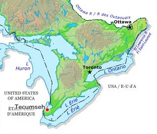
-
Article
Temagami
Temagami originated in the 1890s as a tourist centre, when campers from southern Ontario first discovered the natural beauty of the area, celebrated in a well-known poem by Archibald LAMPMAN. It had previously been an Ojibwa settlement dependent on fur trading.
"https://development.thecanadianencyclopedia.ca/images/tce_placeholder.jpg?v=e9dca980c9bdb3aa11e832e7ea94f5d9" // resources/views/front/categories/view.blade.php
https://development.thecanadianencyclopedia.ca/images/tce_placeholder.jpg?v=e9dca980c9bdb3aa11e832e7ea94f5d9
-
Article
Témiscaming
Témiscaming, Quebec, incorporated as a town in 1988, population 2,368 (2021 census), 2,431 (2016 census). Témiscaming is located at the southern end of Lac Témiscamingue (spelled Timiskaming in Ontario) near the rapids that link the lake with the Ottawa River. In 1888, a sawmill was built nearby.
"https://development.thecanadianencyclopedia.ca/images/tce_placeholder.jpg?v=e9dca980c9bdb3aa11e832e7ea94f5d9" // resources/views/front/categories/view.blade.php
https://development.thecanadianencyclopedia.ca/images/tce_placeholder.jpg?v=e9dca980c9bdb3aa11e832e7ea94f5d9