Browse "Land Features"
-
Article
Aeolian Landform
Wind erosion processes consist of abrasion, the scouring of exposed surfaces by the sand-blasting action of wind-borne material; and deflation, the removal of sand-sized and smaller particles by the wind.
"https://d2ttikhf7xbzbs.cloudfront.net/media/media/cc966717-9f16-4e83-9e03-6015c4e2719a.jpg" // resources/views/front/categories/view.blade.php
https://d2ttikhf7xbzbs.cloudfront.net/media/media/cc966717-9f16-4e83-9e03-6015c4e2719a.jpg
-
Article
Cassiar District
The Cassiar District lies in British Columbia's northwest corner; it historically encompasses the Stikine and Dease River watersheds and that of the upper Taku, NASS and Kechika.
"https://development.thecanadianencyclopedia.ca/images/tce_placeholder.jpg?v=e9dca980c9bdb3aa11e832e7ea94f5d9" // resources/views/front/categories/view.blade.php
https://development.thecanadianencyclopedia.ca/images/tce_placeholder.jpg?v=e9dca980c9bdb3aa11e832e7ea94f5d9
-
Article
Cave
Origins Lava tube caves, an important minor class, are formed by channelled outflow of molten lava in congealing flows. Sea caves most commonly result from erosion by waves.
"https://d2ttikhf7xbzbs.cloudfront.net/media/media/fe40d379-ae39-4fca-8978-e0102f93eb01.jpg" // resources/views/front/categories/view.blade.php
https://d2ttikhf7xbzbs.cloudfront.net/media/media/fe40d379-ae39-4fca-8978-e0102f93eb01.jpg
-
Article
Columbia Icefield
The Columbia Icefield is a mass of ice covering a high plateau between Mount Columbia (3747 m), the highest point in Alberta, and Mount Athabasca (3491 m), located between Banff and Jasper national parks, along the BC-Alberta border.
"https://d2ttikhf7xbzbs.cloudfront.net/media/media/4f68d2f4-7717-496d-a427-bbafb71196fd.jpg" // resources/views/front/categories/view.blade.php
https://d2ttikhf7xbzbs.cloudfront.net/media/media/4f68d2f4-7717-496d-a427-bbafb71196fd.jpg
-
Article
Drumlin
Drumlin, smooth, half egg-shaped or ellipsoidal hill which formed beneath Quaternary GLACIERS. Drumlins [Gaelic druim, "hill"] were first described in Ireland. They lie parallel to the direction of ice movement, the blunt (stoss) end facing up-glacier, the lee sloping down-glacier.
"https://development.thecanadianencyclopedia.ca/images/tce_placeholder.jpg?v=e9dca980c9bdb3aa11e832e7ea94f5d9" // resources/views/front/categories/view.blade.php
https://development.thecanadianencyclopedia.ca/images/tce_placeholder.jpg?v=e9dca980c9bdb3aa11e832e7ea94f5d9
-
Article
Esker
An esker is a ridge (Gaelic eiscir, "ridge") of gravel and sand emplaced during glacial melt by the deposition of sediments from meltwater rivers flowing on the ice (channel fills) or beneath a glacier (tunnel fills).
"https://development.thecanadianencyclopedia.ca/images/tce_placeholder.jpg?v=e9dca980c9bdb3aa11e832e7ea94f5d9" // resources/views/front/categories/view.blade.php
https://development.thecanadianencyclopedia.ca/images/tce_placeholder.jpg?v=e9dca980c9bdb3aa11e832e7ea94f5d9
-
Article
Fjord
In oceanographic terminology, fjords are estuaries, ie, semienclosed bodies of water in which seawater is measurably diluted by fresh water from land drainage.
"https://d2ttikhf7xbzbs.cloudfront.net/media/media/c86e45b6-5998-4dec-b556-28266c7e0f25.jpg" // resources/views/front/categories/view.blade.php
https://d2ttikhf7xbzbs.cloudfront.net/media/media/c86e45b6-5998-4dec-b556-28266c7e0f25.jpg
-
Article
Saguenay River Fjord
The Saguenay Fjord was carved out near the very edge of the North American continental ice sheet. This fjord has the very rare characteristic of being intracontinental.
"https://d2ttikhf7xbzbs.cloudfront.net/media/media/a55e173a-8fe1-4632-be7f-30e85bb60caf.jpg" // resources/views/front/categories/view.blade.php
https://d2ttikhf7xbzbs.cloudfront.net/media/media/a55e173a-8fe1-4632-be7f-30e85bb60caf.jpg
-
Article
Fraser River Canyon
The Fraser River Canyon was formed during the Miocene period (22.9-5.33 million years ago) when the river cut down into the uplifting southern part of the Interior Plateau of British Columbia. The canyon characteristics of this
"https://d2ttikhf7xbzbs.cloudfront.net/media/media/49e5b82d-d0a2-4ca6-aa37-99ecf1243a3d.jpg" // resources/views/front/categories/view.blade.php
https://d2ttikhf7xbzbs.cloudfront.net/media/media/49e5b82d-d0a2-4ca6-aa37-99ecf1243a3d.jpg
-
Article
Glaciers in Canada
A glacier is a large mass of ice, formed at least in part on land, that shows evidence of present or past movement. It is formed by the compaction and recrystallization of snow into ice crystals and commonly also contains air, water and rock debris. With approximately 200,000 km2 of glacier coverage in the Arctic and the West, Canada is home to a significant percentage of the world’s glaciers. By 2100, however, scientists predict that those in Alberta and British Columbia will have lost 70 per cent of their 2005 volume due to climate change.
"https://d2ttikhf7xbzbs.cloudfront.net/media/media/ee830daf-7830-4a20-89bf-0871e3839089.jpg" // resources/views/front/categories/view.blade.php
https://d2ttikhf7xbzbs.cloudfront.net/media/media/ee830daf-7830-4a20-89bf-0871e3839089.jpg
-
Article
Hells Gate
Hells Gate is a narrow rocky gorge of the Fraser River Canyon south of Boston Bar, British Columbia.
"https://d2ttikhf7xbzbs.cloudfront.net/media/media/3a0bfcc6-c4db-40cb-9d96-e5db248cc7e2.jpg" // resources/views/front/categories/view.blade.php
https://d2ttikhf7xbzbs.cloudfront.net/media/media/3a0bfcc6-c4db-40cb-9d96-e5db248cc7e2.jpg
-
Article
Ice Cap
Ice caps are large masses of ice that rest on land and cover most of the underlying landscape.
"https://d2ttikhf7xbzbs.cloudfront.net/media/media/8db9e099-bf02-4b3d-953a-6fdd258ef9d2.jpg" // resources/views/front/categories/view.blade.php
https://d2ttikhf7xbzbs.cloudfront.net/media/media/8db9e099-bf02-4b3d-953a-6fdd258ef9d2.jpg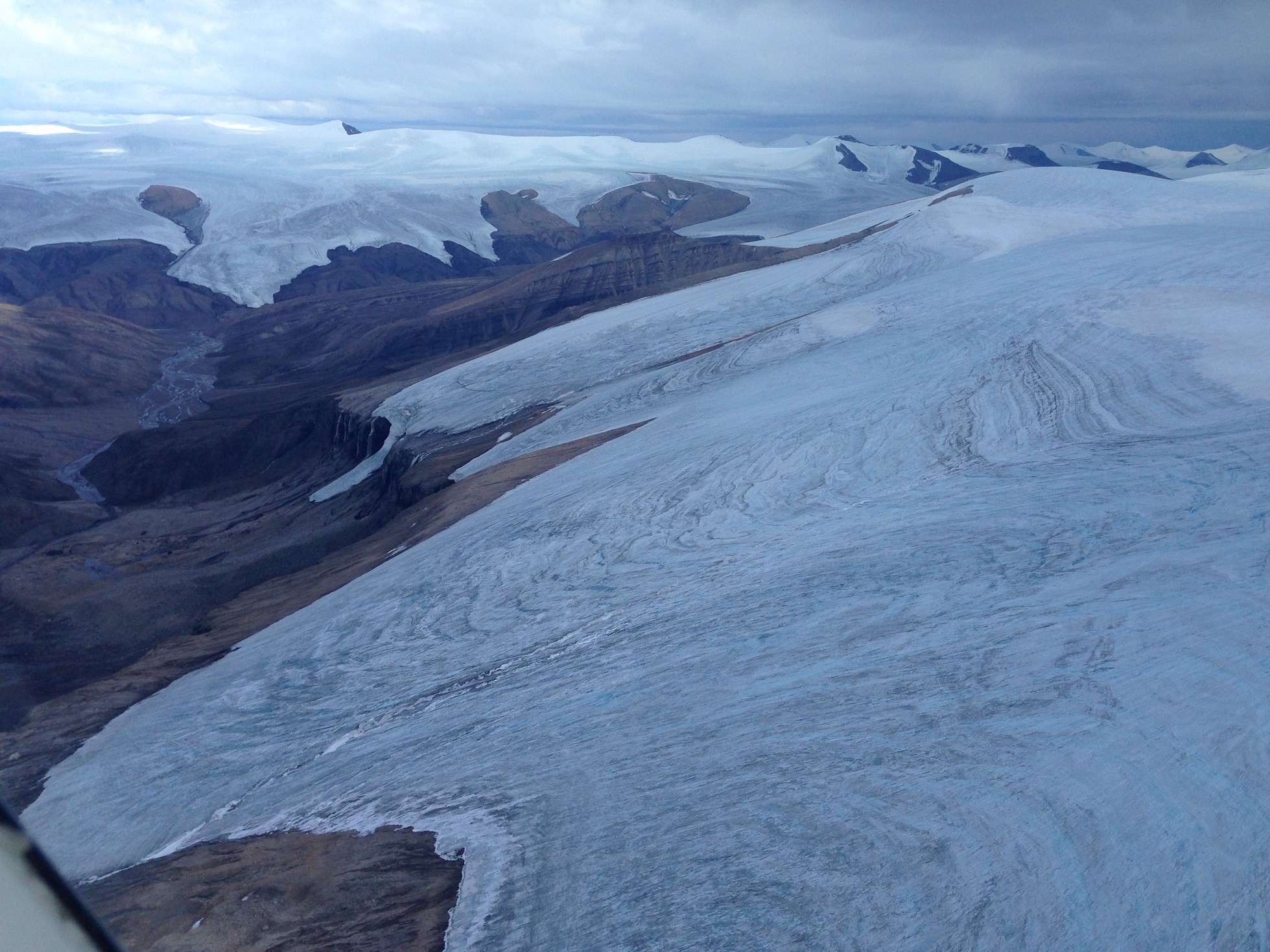
-
Article
Igneous Rock
Early formed, dense crystals may separate from the magma, causing a change in the composition of the residual melt.
"https://development.thecanadianencyclopedia.ca/images/tce_placeholder.jpg?v=e9dca980c9bdb3aa11e832e7ea94f5d9" // resources/views/front/categories/view.blade.php
https://development.thecanadianencyclopedia.ca/images/tce_placeholder.jpg?v=e9dca980c9bdb3aa11e832e7ea94f5d9
-
Article
Meteors, Meteorites and Impact Craters
The solar system contains many objects smaller than the planets (or their satellites) travelling in individual orbits about the SUN; space between the planets also contains myriad dust grains in the micron size range. Near Earth, dust concentrations are only a few hundred particles per cubic kilometre, but 35 000 to 100 000 t of extraterrestrial material enters the atmosphere annually, swept up by our planet from debris that is in its path or crosses its path.
"https://d2ttikhf7xbzbs.cloudfront.net/media/media/66e2415e-3179-44e5-a06b-e73edf3aa050.jpg" // resources/views/front/categories/view.blade.php
https://d2ttikhf7xbzbs.cloudfront.net/media/media/66e2415e-3179-44e5-a06b-e73edf3aa050.jpg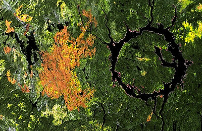
-
Article
Karst Landform
A karst landform is a geological feature created on the earth's surface by the drainage of water into the ground.
"https://d2ttikhf7xbzbs.cloudfront.net/media/media/da6ae2ec-e05e-46fd-916c-6185a6a86215.jpg" // resources/views/front/categories/view.blade.php
https://d2ttikhf7xbzbs.cloudfront.net/media/media/da6ae2ec-e05e-46fd-916c-6185a6a86215.jpg