Browse "Cities & Populated Places"
-
Article
Crowsnest Pass (Alta)
Crowsnest Pass, Alta, incorporated as a municipality in 2008, population 5565 (2011c), 6261 (2006c). The Municipality of Crowsnest Pass is located 269 km southwest of Calgary in the historic CROWSNEST PASS through the Rocky Mountains. The municipality takes its name from a prominent nearby mountain.
"https://d2ttikhf7xbzbs.cloudfront.net/media/media/a9ba436e-b7bf-4c60-be8f-304e450dbf4f.jpg" // resources/views/front/categories/view.blade.php
https://d2ttikhf7xbzbs.cloudfront.net/media/media/a9ba436e-b7bf-4c60-be8f-304e450dbf4f.jpg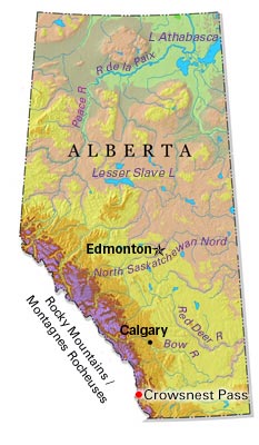
-
Article
Cumberland
Cumberland, BC, incorporated as a village in 1958, population 3398 (2011c), 2762 (2006c). The Village of Cumberland is located on the east coast of Vancouver Island about 14 km south of COURTENAY and 93 km northwest of NANAIMO.
"https://development.thecanadianencyclopedia.ca/images/tce_placeholder.jpg?v=e9dca980c9bdb3aa11e832e7ea94f5d9" // resources/views/front/categories/view.blade.php
https://development.thecanadianencyclopedia.ca/images/tce_placeholder.jpg?v=e9dca980c9bdb3aa11e832e7ea94f5d9
-
Article
Cumberland House
The construction of Cumberland House in 1774 marked a change in HBC policy, which had hitherto expected Indigenous people to bring their furs to the bay posts to trade.
"https://d2ttikhf7xbzbs.cloudfront.net/media/media/ae69d3f2-aebe-4a53-b1a8-ddfebac57e3f.jpg" // resources/views/front/categories/view.blade.php
https://d2ttikhf7xbzbs.cloudfront.net/media/media/ae69d3f2-aebe-4a53-b1a8-ddfebac57e3f.jpg
-
Article
Cupids
Cupids, Newfoundland and Labrador, incorporated as a town in 1965, population 743 (2016 census), 761 (2011 census). The town of Cupids is located in southwest Conception Bay on the Avalon Peninsula, about 80 km west of St. John's. Originally known as Cupers Cove (1610), other early variants of the name include Cuperts Cove and Kibby's Cove. However, the name Cupids Cove appears quite early: Sir William Alexander referred to it by this name in his An Encouragement to Colonies (1624). No one knows the origin of the name, but it may be an anglicized version of a Spanish or Basque name.
"https://d2ttikhf7xbzbs.cloudfront.net/media/media/4cdbbbd0-441a-4bc7-b1bb-d46b1b94b893.jpg" // resources/views/front/categories/view.blade.php
https://d2ttikhf7xbzbs.cloudfront.net/media/media/4cdbbbd0-441a-4bc7-b1bb-d46b1b94b893.jpg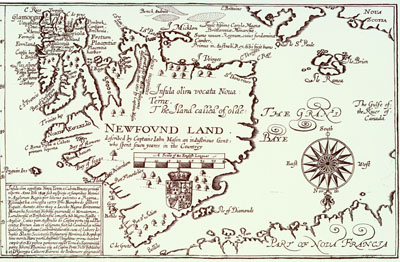
-
Article
Dalhousie
Dalhousie, NB, incorporated as a town in 1905, population 3512 (2011c), 3676 (2006c). The Town of Dalhousie, the shire town of Restigouche County (since 1837), is located on New Brunswick's north shore at the mouth of the Restigouche River.
"https://d2ttikhf7xbzbs.cloudfront.net/media/media/0eeeb273-5c1d-4e2c-9fa2-9ea5b597137e.jpg" // resources/views/front/categories/view.blade.php
https://d2ttikhf7xbzbs.cloudfront.net/media/media/0eeeb273-5c1d-4e2c-9fa2-9ea5b597137e.jpg
-
Article
Dalmeny
Dalmeny, Sask, incorporated as a town in 1983, population 1702 (2011c), 1560 (2006c). The Town of Dalmeny is located 30 km northwest of SASKATOON. It is apparently named after Dalmeny, Scotland.
"https://development.thecanadianencyclopedia.ca/images/tce_placeholder.jpg?v=e9dca980c9bdb3aa11e832e7ea94f5d9" // resources/views/front/categories/view.blade.php
https://development.thecanadianencyclopedia.ca/images/tce_placeholder.jpg?v=e9dca980c9bdb3aa11e832e7ea94f5d9
-
Article
Dartmouth
Dartmouth, Nova Scotia, metropolitan area, population (including Cole Harbour) 96,165 (2021 census), 92,301 (2016 census). Dartmouth is located on the eastern side of Halifax Harbour in the Halifax Regional Municipality (incorporated in 1996).
"https://d2ttikhf7xbzbs.cloudfront.net/media/media/09ef6dac-263c-4515-92b7-f062849a532b.jpg" // resources/views/front/categories/view.blade.php
https://d2ttikhf7xbzbs.cloudfront.net/media/media/09ef6dac-263c-4515-92b7-f062849a532b.jpg
-
Article
Dauphin
Pierre de LA VÉRENDRYE first visited the area in the 1730s and gave the name Dauphin, for the eldest son of the king of France, to a post in the area (1741).
"https://development.thecanadianencyclopedia.ca/images/tce_placeholder.jpg?v=e9dca980c9bdb3aa11e832e7ea94f5d9" // resources/views/front/categories/view.blade.php
https://development.thecanadianencyclopedia.ca/images/tce_placeholder.jpg?v=e9dca980c9bdb3aa11e832e7ea94f5d9
-
Article
Dawson
Dawson (also Dawson City), Yukon, incorporated as a town in 1904, population 1,577 (2021 census), 1,375 (2016 census). The Town of Dawson is located on the east bank of the Yukon River at the mouth of the Klondike River, 530 km north of Whitehorse.
"https://d2ttikhf7xbzbs.cloudfront.net/media/media/9c017727-fcf3-484b-9dbb-02f507e8486e.jpg" // resources/views/front/categories/view.blade.php
https://d2ttikhf7xbzbs.cloudfront.net/media/media/9c017727-fcf3-484b-9dbb-02f507e8486e.jpg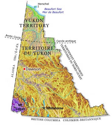
-
Article
Dawson Creek
Dawson Creek, BC, incorporated as a city in 1958, population 11 583 (2011c), 10 994 (2006c). The City of Dawson Creek is located near the British Columbia-Alberta border, about 406 km northeast of Prince George and 589 km northwest of Edmonton.
"https://development.thecanadianencyclopedia.ca/images/tce_placeholder.jpg?v=e9dca980c9bdb3aa11e832e7ea94f5d9" // resources/views/front/categories/view.blade.php
https://development.thecanadianencyclopedia.ca/images/tce_placeholder.jpg?v=e9dca980c9bdb3aa11e832e7ea94f5d9
-
Article
Deep River
Deep River, Ont, incorporated as a town in 1959, population 4193 (2011c), 4216 (2006c). The Town of Deep River is located in eastern Ontario, 208 km northwest of Ottawa.
"https://development.thecanadianencyclopedia.ca/images/tce_placeholder.jpg?v=e9dca980c9bdb3aa11e832e7ea94f5d9" // resources/views/front/categories/view.blade.php
https://development.thecanadianencyclopedia.ca/images/tce_placeholder.jpg?v=e9dca980c9bdb3aa11e832e7ea94f5d9
-
Article
Déline
Déline, NWT, incorporated as a charter community in 1993, population 472 (2011c), 525 (2006c). The Charter Community of Déline is located on the shores of GREAT BEAR LAKE, 544 air km northwest of Yellowknife.
"https://d2ttikhf7xbzbs.cloudfront.net/media/media/b504d03a-1419-4bf4-ab27-00b5e8cc89a0.jpg" // resources/views/front/categories/view.blade.php
https://d2ttikhf7xbzbs.cloudfront.net/media/media/b504d03a-1419-4bf4-ab27-00b5e8cc89a0.jpg
-
Article
Delson
Delson was built up around a junction of the Delaware and Hudson and GRAND TRUNK railway lines. Originally known as Delson Junction, its name is the joining of the first syllable of Delaware to the last syllable of Hudson.
"https://d2ttikhf7xbzbs.cloudfront.net/media/media/da531432-97bc-4fae-93a5-73c5258cab76.jpg" // resources/views/front/categories/view.blade.php
https://d2ttikhf7xbzbs.cloudfront.net/media/media/da531432-97bc-4fae-93a5-73c5258cab76.jpg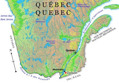
-
Article
Delta (BC)
Delta, BC, incorporated as a district municipality in 1879, population 99 863 (2011c), 96 635 (2006c). The Corporation of Delta is located in the southern part of Metro VANCOUVER - south of the FRASER RIVER, west of the city of SURREY and touching the US border.
"https://d2ttikhf7xbzbs.cloudfront.net/media/media/44424997-7072-4b3b-ba5f-753d7b3caa89.jpg" // resources/views/front/categories/view.blade.php
https://d2ttikhf7xbzbs.cloudfront.net/media/media/44424997-7072-4b3b-ba5f-753d7b3caa89.jpg
-
Article
Destruction Bay
Destruction Bay, Yukon, Settlement, population 35 (2011c), 55 (2006c). Destruction Bay is located on the west side of Kluane Lake between HAINES JUNCTION and BURWASH LANDING at Mile 1083 on the Alaska Highway.
"https://development.thecanadianencyclopedia.ca/images/tce_placeholder.jpg?v=e9dca980c9bdb3aa11e832e7ea94f5d9" // resources/views/front/categories/view.blade.php
https://development.thecanadianencyclopedia.ca/images/tce_placeholder.jpg?v=e9dca980c9bdb3aa11e832e7ea94f5d9