Browse "Cities & Populated Places"
-
"https://development.thecanadianencyclopedia.ca/images/tce_placeholder.jpg?v=e9dca980c9bdb3aa11e832e7ea94f5d9" // resources/views/front/categories/view.blade.php
https://development.thecanadianencyclopedia.ca/images/tce_placeholder.jpg?v=e9dca980c9bdb3aa11e832e7ea94f5d9
-
Article
Dundas
Dundas, Ont, Urban Community within the city of Hamilton. Dundas is located at the west end of Lake Ontario and is situated between 2 faces of the Niagara Escarpment.
"https://d2ttikhf7xbzbs.cloudfront.net/media/media/16ee164e-d06a-4543-9a83-163fa2ae8aa4.jpg" // resources/views/front/categories/view.blade.php
https://d2ttikhf7xbzbs.cloudfront.net/media/media/16ee164e-d06a-4543-9a83-163fa2ae8aa4.jpg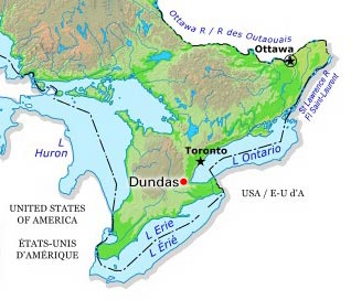
-
Article
Dunnville
Dunnville, Ont, urban area, population 5789 (2011c), 5729 (2006c). Dunnville was established in 1974 as a town in the Regional Municipality of Haldimand-Norfolk from the former townships of Canborough, Dunn, Moulton and Sherbrooke and the town of Dunnville.
"https://development.thecanadianencyclopedia.ca/images/tce_placeholder.jpg?v=e9dca980c9bdb3aa11e832e7ea94f5d9" // resources/views/front/categories/view.blade.php
https://development.thecanadianencyclopedia.ca/images/tce_placeholder.jpg?v=e9dca980c9bdb3aa11e832e7ea94f5d9
-
Article
East Gwillimbury
East Gwillimbury, Ontario, incorporated as a town in 1971, population 34,637 (2021 census), 23,991 (2016 census). Located in York Region, East Gwillimbury’s northern border is less than a kilometre from Lake Simcoe. Historic communities within East Gwillimbury include Sharon, Holland Landing, Queensville and Mount Albert. As of 2021, the town was Canada’s fastest growing municipality of over 5,000 people, with a population increase of over 44 per cent between 2016 and 2021. Throughout history, the East Gwillimbury area has been home to different Indigenous groups, namely the Wendat (Huron), Tionontati (Petun), Haudenosaunee and Anishinaabeg, including the Chippewas of Georgina Island First Nation. The land is part of the Williams Treaties (1923).
"https://d2ttikhf7xbzbs.cloudfront.net/EastGwillimbury/SharonTemple.jpg" // resources/views/front/categories/view.blade.php
https://d2ttikhf7xbzbs.cloudfront.net/EastGwillimbury/SharonTemple.jpg
-
Article
East York
East York, Ont, Urban Community within the city of Toronto. East York was a borough until it was merged in 1998 into the new city of Toronto.
"https://d2ttikhf7xbzbs.cloudfront.net/media/media/a7323b4e-dfc4-4ae9-83c8-83937b615bf9.jpg" // resources/views/front/categories/view.blade.php
https://d2ttikhf7xbzbs.cloudfront.net/media/media/a7323b4e-dfc4-4ae9-83c8-83937b615bf9.jpg
-
Article
Eastern Townships
The Eastern Townships region is located in the Appalachian hills of south-central Quebec, between Montreal and Quebec City. The townships extend from Granby to Lac Mégantic and from Drummondville to the US border.
"https://d2ttikhf7xbzbs.cloudfront.net/media/media/2235ed70-ba4f-43c4-81e1-53b22e3e71bd.jpg" // resources/views/front/categories/view.blade.php
https://d2ttikhf7xbzbs.cloudfront.net/media/media/2235ed70-ba4f-43c4-81e1-53b22e3e71bd.jpg
-
Article
Eckville
Eckville, Alta, incorporated as a village in 1921 and as a town in 1966, population 1125 (2011c), 951 (2006c).
"https://development.thecanadianencyclopedia.ca/images/tce_placeholder.jpg?v=e9dca980c9bdb3aa11e832e7ea94f5d9" // resources/views/front/categories/view.blade.php
https://development.thecanadianencyclopedia.ca/images/tce_placeholder.jpg?v=e9dca980c9bdb3aa11e832e7ea94f5d9
-
Article
Edenwold
Edenwold, Sask, incorporated as a village in 1912, population 238 (2011c), 242 (2006c). The Village of Edenwold is located 44 km northeast of REGINA. The name was originally Edenwald after the Garden of Eden and wald, meaning forest in German.
"https://development.thecanadianencyclopedia.ca/images/tce_placeholder.jpg?v=e9dca980c9bdb3aa11e832e7ea94f5d9" // resources/views/front/categories/view.blade.php
https://development.thecanadianencyclopedia.ca/images/tce_placeholder.jpg?v=e9dca980c9bdb3aa11e832e7ea94f5d9
-
Article
Edmonton Elks
The Edmonton Elks (formerly the Edmonton Football Team, or EE Football Team, and the Edmonton Eskimos) is a community-owned football team that plays in the West Division of the Canadian Football League (CFL). In the CFL’s modern era (post-Second World War), the team has won the second-most Grey Cup championships (14). This included three victories in a row from 1954 to 1956 and an unprecedented five straight championships from 1978 to 1982. The club also holds the North American professional sports record for reaching the playoffs in 34 consecutive seasons (1972–2005). Notable alumni include former Alberta premiers Peter Lougheed and Don Getty, former lieutenant-governor of Alberta Norman Kwong, former Edmonton mayor Bill Smith, and former NFL star Warren Moon.
"https://d2ttikhf7xbzbs.cloudfront.net/media/media/eea23e59-cc99-4d53-a7e4-03625f457ad7.jpg" // resources/views/front/categories/view.blade.php
https://d2ttikhf7xbzbs.cloudfront.net/media/media/eea23e59-cc99-4d53-a7e4-03625f457ad7.jpg
-
Article
Edmundston
Edmundston, NB, incorporated as a city in 1952, population 16 032 (2011c), 16 643 (2006c). The City of Edmundston is nestled on the eastern bank of the SAINT JOHN RIVER, opposite Madawaska, Maine, and 285 km north of FREDERICTON.
"https://d2ttikhf7xbzbs.cloudfront.net/media/media/2c4f402b-5afa-471d-a37c-786a92a57dc4.jpg" // resources/views/front/categories/view.blade.php
https://d2ttikhf7xbzbs.cloudfront.net/media/media/2c4f402b-5afa-471d-a37c-786a92a57dc4.jpg
-
Article
Edson
Edson, Alta, incorporated as a village then as a town in 1911, population 8475 (2011c), 8098 (2006c). The Town of Edson is the distribution centre for a mining, timber and oil area 200 km due west of Edmonton. Named for Edson J.
"https://d2ttikhf7xbzbs.cloudfront.net/media/media/2a873a72-a5a8-4819-8605-59b9966ba43d.jpg" // resources/views/front/categories/view.blade.php
https://d2ttikhf7xbzbs.cloudfront.net/media/media/2a873a72-a5a8-4819-8605-59b9966ba43d.jpg
-
Article
Elbow
The first settlers appear to have been ranchers. By 1903 settlers were taking up homesteads near Elbow, and by the end of the decade lands in the elbow were extensively occupied. The CANADIAN PACIFIC RAILWAY, which arrived in 1908, has accounted for the continued existence of the village.
"https://development.thecanadianencyclopedia.ca/images/tce_placeholder.jpg?v=e9dca980c9bdb3aa11e832e7ea94f5d9" // resources/views/front/categories/view.blade.php
https://development.thecanadianencyclopedia.ca/images/tce_placeholder.jpg?v=e9dca980c9bdb3aa11e832e7ea94f5d9
-
Article
Elkford
Elkford, British Columbia, incorporated as a district municipality in 1981, population 2,499 (2016 census), 2,523 (2011 census). The District of Elkford is situated on the west side of the Elk River. The Elk River is a tributary to the Kootenay River, in the East Kootenay district of southeastern British Columbia. The district is 35 km north of Sparwood. It’s located among the Rocky Mountains, near the old coal-mining communities of Crowsnest Pass, and on the traditional territory of the Ktunaxa people. At 1,300 m elevation, Elkford is the highest community in British Columbia.
"https://development.thecanadianencyclopedia.ca/images/tce_placeholder.jpg?v=e9dca980c9bdb3aa11e832e7ea94f5d9" // resources/views/front/categories/view.blade.php
https://development.thecanadianencyclopedia.ca/images/tce_placeholder.jpg?v=e9dca980c9bdb3aa11e832e7ea94f5d9
-
Article
Elliot Lake
Elliot Lake, Ont, incorporated as a city in 1991, population 11 348 (2011c), 11 549 (2006c).
"https://development.thecanadianencyclopedia.ca/images/tce_placeholder.jpg?v=e9dca980c9bdb3aa11e832e7ea94f5d9" // resources/views/front/categories/view.blade.php
https://development.thecanadianencyclopedia.ca/images/tce_placeholder.jpg?v=e9dca980c9bdb3aa11e832e7ea94f5d9
-
Article
Elmira
Elmira, Ontario, urban area, population 9931 (2011c), 8872 (2006c). Elmira is located about 17 km northwest of KITCHENER-WATERLOO.
"https://development.thecanadianencyclopedia.ca/images/tce_placeholder.jpg?v=e9dca980c9bdb3aa11e832e7ea94f5d9" // resources/views/front/categories/view.blade.php
https://development.thecanadianencyclopedia.ca/images/tce_placeholder.jpg?v=e9dca980c9bdb3aa11e832e7ea94f5d9