Browse "Cities & Populated Places"
-
Article
Harbour Breton
Harbour Breton, NL, incorporated as a town in 1952, population 1711 (2011c), 1877 (2006c). The Town of Harbour Breton is situated around a protected harbour near the mouth of Fortune Bay on Newfoundland's south coast.
"https://development.thecanadianencyclopedia.ca/images/tce_placeholder.jpg?v=e9dca980c9bdb3aa11e832e7ea94f5d9" // resources/views/front/categories/view.blade.php
https://development.thecanadianencyclopedia.ca/images/tce_placeholder.jpg?v=e9dca980c9bdb3aa11e832e7ea94f5d9
-
Article
Harbour Grace
Harbour Grace, NL, incorporated as a town in 1945, population 3131 (2011c), 3074 (2006c). The Town of Harbour Grace, with its commodious harbour in western Conception Bay, was named for the French Havre de Grâce.
"https://development.thecanadianencyclopedia.ca/images/tce_placeholder.jpg?v=e9dca980c9bdb3aa11e832e7ea94f5d9" // resources/views/front/categories/view.blade.php
https://development.thecanadianencyclopedia.ca/images/tce_placeholder.jpg?v=e9dca980c9bdb3aa11e832e7ea94f5d9
-
Article
Hartland
Hartland, NB, incorporated as a town in 1918, population 947 (2011c), 947 (2006c). The Town of Hartland is located at the mouth of Becaguimec Stream, 124 km upriver from Fredericton on the SAINT JOHN RIVER.
"https://d2ttikhf7xbzbs.cloudfront.net/media/media/47b24fcb-cb02-4988-ac93-8d8199dd5a7f.jpg" // resources/views/front/categories/view.blade.php
https://d2ttikhf7xbzbs.cloudfront.net/media/media/47b24fcb-cb02-4988-ac93-8d8199dd5a7f.jpg
-
Article
Hawkesbury
Hawkesbury, Ontario, incorporated as a town in 1896, population 10,263 (2016 census), 10,551 (2011 census). The town of Hawkesbury is located on the Ottawa River, 95 km east of Ottawa.
"https://development.thecanadianencyclopedia.ca/images/tce_placeholder.jpg?v=e9dca980c9bdb3aa11e832e7ea94f5d9" // resources/views/front/categories/view.blade.php
https://development.thecanadianencyclopedia.ca/images/tce_placeholder.jpg?v=e9dca980c9bdb3aa11e832e7ea94f5d9
-
Article
Hay River
Hay River, Northwest Territories, incorporated as a town in 1963, population 3,169 (2021 census), 3,528 (2016 census). The town of Hay River is located on the south shore of Great Slave Lake at the mouth of the Hay River, about 200 air km southwest of Yellowknife.
"https://d2ttikhf7xbzbs.cloudfront.net/media/media/033734fa-dbda-414b-a290-f459d2a67b5a.jpg" // resources/views/front/categories/view.blade.php
https://d2ttikhf7xbzbs.cloudfront.net/media/media/033734fa-dbda-414b-a290-f459d2a67b5a.jpg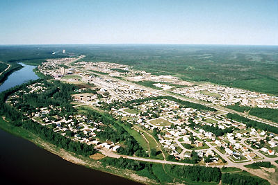
-
Article
Hazelton
Hazelton, British Columbia, incorporated as a village in 1956, population 270 (2011c), 293 (2006c). The Village of Hazelton is situated at the confluence of the Skeena and Bulkley rivers. The townsite was laid out by Edgar DEWDNEY in 1871 next to the GITKSAN village of Gitanmaax.
"https://development.thecanadianencyclopedia.ca/images/tce_placeholder.jpg?v=e9dca980c9bdb3aa11e832e7ea94f5d9" // resources/views/front/categories/view.blade.php
https://development.thecanadianencyclopedia.ca/images/tce_placeholder.jpg?v=e9dca980c9bdb3aa11e832e7ea94f5d9
-
Article
Hearst
Hearst, Ont, incorporated as a town in 1922, population 5090 (2011c), 5620 (2006c). The Town of Hearst is situated in the Cochrane District of northeastern Ontario on the Mattawishkwia River, 260 km northwest of TIMMINS.
"https://development.thecanadianencyclopedia.ca/images/tce_placeholder.jpg?v=e9dca980c9bdb3aa11e832e7ea94f5d9" // resources/views/front/categories/view.blade.php
https://development.thecanadianencyclopedia.ca/images/tce_placeholder.jpg?v=e9dca980c9bdb3aa11e832e7ea94f5d9
-
Article
Heart's Content
Heart's Content, NL, incorporated as a town in 1967, population 418 (2011c), 418 (2006c). The Town of Heart's Content is a fishing community on a protected, urn-shaped harbour in eastern Trinity Bay.
"https://development.thecanadianencyclopedia.ca/images/tce_placeholder.jpg?v=e9dca980c9bdb3aa11e832e7ea94f5d9" // resources/views/front/categories/view.blade.php
https://development.thecanadianencyclopedia.ca/images/tce_placeholder.jpg?v=e9dca980c9bdb3aa11e832e7ea94f5d9
-
Collection
Heritage Minutes
The Heritage Minutes collection is a bilingual series of history-focused public service announcements. Each 60-second short film depicts a significant person, event or story in Canadian history. They are produced by Historica Canada, the not-for-profit organization that also publishes this encyclopedia. First released in 1991, the Heritage Minutes have been shown on television, in cinemas and online. They have become a recognizable part of Canadian culture. The collection currently includes 100 episodes.
"https://d2ttikhf7xbzbs.cloudfront.net/media/media/1bfa3d45-2952-4f79-b7d4-4c6cb6601164.jpg" // resources/views/front/categories/view.blade.php
https://d2ttikhf7xbzbs.cloudfront.net/media/media/1bfa3d45-2952-4f79-b7d4-4c6cb6601164.jpg
-
"https://development.thecanadianencyclopedia.ca/images/tce_placeholder.jpg?v=e9dca980c9bdb3aa11e832e7ea94f5d9" // resources/views/front/categories/view.blade.php
https://development.thecanadianencyclopedia.ca/images/tce_placeholder.jpg?v=e9dca980c9bdb3aa11e832e7ea94f5d9
-
Article
High Level
High Level, Alta, incorporated as a town in 1983, population 3641 (2011c), 3887 (2006c). The Town of High Level is located 250 km north of the town of PEACE RIVER and was named for a high expanse of land separating the Hay and PEACE river systems.
"https://development.thecanadianencyclopedia.ca/images/tce_placeholder.jpg?v=e9dca980c9bdb3aa11e832e7ea94f5d9" // resources/views/front/categories/view.blade.php
https://development.thecanadianencyclopedia.ca/images/tce_placeholder.jpg?v=e9dca980c9bdb3aa11e832e7ea94f5d9
-
Article
High Prairie
High Prairie, Alta, incorporated as a village in 1945 and as a town in 1950, population 2600 (2011c), 2785 (2006c). Located on the south edge of the Peace River region, the Town of High Prairie is 365 km northwest of Edmonton and 200 km northeast of Grande Prairie.
"https://d2ttikhf7xbzbs.cloudfront.net/media/media/430178ab-66e7-4f64-a004-dcce0b8ac820.jpg" // resources/views/front/categories/view.blade.php
https://d2ttikhf7xbzbs.cloudfront.net/media/media/430178ab-66e7-4f64-a004-dcce0b8ac820.jpg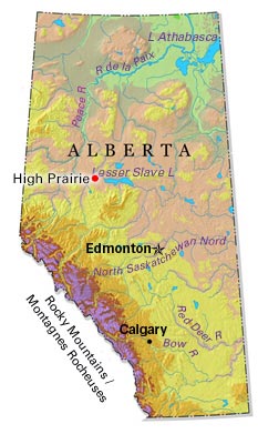
-
"https://development.thecanadianencyclopedia.ca/images/tce_placeholder.jpg?v=e9dca980c9bdb3aa11e832e7ea94f5d9" // resources/views/front/categories/view.blade.php
https://development.thecanadianencyclopedia.ca/images/tce_placeholder.jpg?v=e9dca980c9bdb3aa11e832e7ea94f5d9
-
Article
History of Acadia
Acadia’s history as a French-speaking colony stretches as far back as the early 17th century. The French settlers who colonized the land and coexisted alongside Indigenous peoples became called Acadians. Acadia was also the target of numerous wars between the French and the English. Ultimately, the colony fell under British rule. Many Acadians were subsequently deported away from Acadia. Over time, as a British colony and then as part of Canada, Acadians increasingly became a linguistic minority. Nonetheless, Acadians have strived to protect their language and identity throughout time.
"https://d2ttikhf7xbzbs.cloudfront.net/media/media/66c056b0-bee3-47a2-9680-5d5a50b5e7eb.jpg" // resources/views/front/categories/view.blade.php
https://d2ttikhf7xbzbs.cloudfront.net/media/media/66c056b0-bee3-47a2-9680-5d5a50b5e7eb.jpg
-
Article
Holyrood
Holyrood, NL, incorporated as a town in 1969, population 1995 (2011c), 2005 (2006c). The Town of Holyrood is located at the head of Conception Bay on the Avalon Peninsula about 50 km west of St John's.
"https://development.thecanadianencyclopedia.ca/images/tce_placeholder.jpg?v=e9dca980c9bdb3aa11e832e7ea94f5d9" // resources/views/front/categories/view.blade.php
https://development.thecanadianencyclopedia.ca/images/tce_placeholder.jpg?v=e9dca980c9bdb3aa11e832e7ea94f5d9