Browse "Cities & Populated Places"
-
Article
Hope
Hope, BC, incorporated as a district municipality in 1992, population 5969 (2011c), 6185 (2006c). The District of Hope is located on the Trans-Canada Highway, 150 km east of VANCOUVER where it sits on the east bank of the FRASER RIVER, surrounded on three sides by mountains.
"https://development.thecanadianencyclopedia.ca/images/tce_placeholder.jpg?v=e9dca980c9bdb3aa11e832e7ea94f5d9" // resources/views/front/categories/view.blade.php
https://development.thecanadianencyclopedia.ca/images/tce_placeholder.jpg?v=e9dca980c9bdb3aa11e832e7ea94f5d9
-
Article
Houston
Houston, BC, incorporated as a district municipality in 1969, population 3147 (2011c), 3163 (2006c). The District of Houston is situated midway between PRINCE GEORGE and PRINCE RUPERT on the Yellowhead Highway and at the confluence of the Bulkley and Morice rivers.
"https://development.thecanadianencyclopedia.ca/images/tce_placeholder.jpg?v=e9dca980c9bdb3aa11e832e7ea94f5d9" // resources/views/front/categories/view.blade.php
https://development.thecanadianencyclopedia.ca/images/tce_placeholder.jpg?v=e9dca980c9bdb3aa11e832e7ea94f5d9
-
Article
Hudson
This wealthy residential suburb of Montréal is proud of its stately homes, and its residents also highly value a great variety of sports and cultural activities. The town's economy lacks an industrial base.
"https://d2ttikhf7xbzbs.cloudfront.net/media/media/138d11c8-39df-4cf2-9c45-897962add14b.jpg" // resources/views/front/categories/view.blade.php
https://d2ttikhf7xbzbs.cloudfront.net/media/media/138d11c8-39df-4cf2-9c45-897962add14b.jpg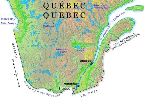
-
Article
Hudson Bay (Sask)
By the end of WWII the community had grown sufficiently to obtain town status, a fact emphasized by dropping "Junction" from its name (1947). Since then, while growth has continued, the economy has been modified.
"https://development.thecanadianencyclopedia.ca/images/tce_placeholder.jpg?v=e9dca980c9bdb3aa11e832e7ea94f5d9" // resources/views/front/categories/view.blade.php
https://development.thecanadianencyclopedia.ca/images/tce_placeholder.jpg?v=e9dca980c9bdb3aa11e832e7ea94f5d9
-
Article
Hull
Hull, Quebec, is part of the city of Gatineau. Originally its own municipality, Hull amalgamated with the municipalities of Aylmer, Buckingham, Gatineau and Masson-Angers in 2002. When Hull was incorporated in 1875, it was named after the township in which it was situated. In turn, Hull Township got its name from the city of Hull in Yorkshire, England.
"https://d2ttikhf7xbzbs.cloudfront.net/media/media/803bc157-04ec-48c6-8f84-23149e23faad.jpg" // resources/views/front/categories/view.blade.php
https://d2ttikhf7xbzbs.cloudfront.net/media/media/803bc157-04ec-48c6-8f84-23149e23faad.jpg
-
Article
Humboldt
Its designation as a railway divisional point fostered growth, as did the establishment of St Peters Colony (50 townships) by the Roman Catholic Order of St Benedict (1903).
"https://development.thecanadianencyclopedia.ca/images/tce_placeholder.jpg?v=e9dca980c9bdb3aa11e832e7ea94f5d9" // resources/views/front/categories/view.blade.php
https://development.thecanadianencyclopedia.ca/images/tce_placeholder.jpg?v=e9dca980c9bdb3aa11e832e7ea94f5d9
-
Article
Huntsville
Huntsville, Ont, incorporated as a town in 1900, population 19 056 (2011c), 18 280 (2006c). The Town of Huntsville is located 215 km north of Toronto on a short section of the Muskoka River connecting Vernon and Fairy lakes.
"https://d2ttikhf7xbzbs.cloudfront.net/media/media/d0fdd9f6-db3d-4408-99a3-2c5eb442fbea.jpg" // resources/views/front/categories/view.blade.php
https://d2ttikhf7xbzbs.cloudfront.net/media/media/d0fdd9f6-db3d-4408-99a3-2c5eb442fbea.jpg
-
Article
Iberville
Visitors are attracted by Iberville's impressive Roman Catholic church, local vineyards and picturesque riverside setting. Iberville and the surrounding region were hard hit by the January 1998 ice storm that slashed across eastern Ontario and southern Québec.
"https://d2ttikhf7xbzbs.cloudfront.net/media/media/6ecaaa8b-d704-4641-98f4-e22db45e4668.jpg" // resources/views/front/categories/view.blade.php
https://d2ttikhf7xbzbs.cloudfront.net/media/media/6ecaaa8b-d704-4641-98f4-e22db45e4668.jpg
-
Article
Igloolik
Igloolik, Nunavut, incorporated as a hamlet in 1976, population 1454 (2011c), 1538 (2006c). The Hamlet of Igloolik is located on an island of the same name at the eastern entrance to FURY AND HECLA STRAIT, off the coast of the MELVILLE PENINSULA.
"https://d2ttikhf7xbzbs.cloudfront.net/media/media/75e593e0-0331-436c-92db-8ff4782a8e02.jpg" // resources/views/front/categories/view.blade.php
https://d2ttikhf7xbzbs.cloudfront.net/media/media/75e593e0-0331-436c-92db-8ff4782a8e02.jpg
-
Article
Indian Head
Indian Head, Sask, incorporated as a town in 1902, population 1815 (2011c), 1634 (2006c). The Town of Indian Head is located in the heart of Saskatchewan's richest farming area, south of the Qu'Appelle Valley, 69 km east of
"https://development.thecanadianencyclopedia.ca/images/tce_placeholder.jpg?v=e9dca980c9bdb3aa11e832e7ea94f5d9" // resources/views/front/categories/view.blade.php
https://development.thecanadianencyclopedia.ca/images/tce_placeholder.jpg?v=e9dca980c9bdb3aa11e832e7ea94f5d9
-
Article
Ingersoll
Ingersoll, Ont, incorporated as a town in 1865, population 12 146 (2011c), 11 760 (2006c). The Town of Ingersoll is situated on the THAMES RIVER, 36 km east of London.
"https://development.thecanadianencyclopedia.ca/images/tce_placeholder.jpg?v=e9dca980c9bdb3aa11e832e7ea94f5d9" // resources/views/front/categories/view.blade.php
https://development.thecanadianencyclopedia.ca/images/tce_placeholder.jpg?v=e9dca980c9bdb3aa11e832e7ea94f5d9
-
Article
Innisfail
Innisfail, Alta, incorporated as a town in 1903, population 7876 (2011c), 7331 (2006c). The Town of Innisfail is located on the CP Rail line 121 km north of Calgary.
"https://d2ttikhf7xbzbs.cloudfront.net/media/media/1e459b6f-fe80-4090-8780-016a87e863bd.jpg" // resources/views/front/categories/view.blade.php
https://d2ttikhf7xbzbs.cloudfront.net/media/media/1e459b6f-fe80-4090-8780-016a87e863bd.jpg
-
Article
Innisfil
Innisfil, Ontario, incorporated as a town in 1991, population 43,326 (2021 census), 36,566 (2016 census). The town of Innisfil is located 75 km north of Toronto along the shore of Lake Simcoe.
"https://d2ttikhf7xbzbs.cloudfront.net/media/media/4541da10-f493-4d2b-bf7b-9e1a825d7c64.jpg" // resources/views/front/categories/view.blade.php
https://d2ttikhf7xbzbs.cloudfront.net/media/media/4541da10-f493-4d2b-bf7b-9e1a825d7c64.jpg
-
Article
Inuvik
Inuvik, NWT, incorporated as a town in 1970, population 3463 (2011c), 3484 (2006c). The Town of Inuvik is located on the MACKENZIE RIVER delta, 97 km south of the BEAUFORT SEA and 1086 air km northwest of Yellowknife.
"https://d2ttikhf7xbzbs.cloudfront.net/media/media/e6b68eba-9d02-4243-97c0-eb058faa8ce2.jpg" // resources/views/front/categories/view.blade.php
https://d2ttikhf7xbzbs.cloudfront.net/media/media/e6b68eba-9d02-4243-97c0-eb058faa8ce2.jpg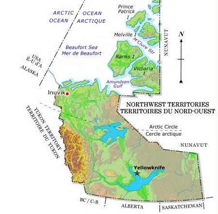
-
Article
Invermere
Invermere, British Columbia, incorporated as a district municipality in 1983, population 3,391 (2016 census), 2,955 (2011 census). The District of Invermere is located on the northwestern shore of Windermere Lake in the Rocky Mountain Trench. Invermere is 130 km north of Cranbrook and 120 km southeast of Golden.
"https://development.thecanadianencyclopedia.ca/images/tce_placeholder.jpg?v=e9dca980c9bdb3aa11e832e7ea94f5d9" // resources/views/front/categories/view.blade.php
https://development.thecanadianencyclopedia.ca/images/tce_placeholder.jpg?v=e9dca980c9bdb3aa11e832e7ea94f5d9