Browse "Cities & Populated Places"
-
Article
Kingston
Kingston, Ontario, incorporated as a city 1846, population 132,485 (2021 census), 123,798 (2016 census). Kingston was first settled in 1783, incorporated as a town in 1838 and as a city in 1846. It is located approximately 175 km southwest of Ottawa, 290 km west of Montreal and 260 km east of Toronto. The former capital of the Province of Canada (1841), Kingston’s position at the junction of the Great Lakes and St. Lawrence River, its proximity to the border with the United States and the dominance of the Canadian Shield in its surrounding area, have been crucial to its settlement, political and economic history.
"https://d2ttikhf7xbzbs.cloudfront.net/media/media/5de2aed2-3622-4d06-8d8f-e28c382a7566.jpg" // resources/views/front/categories/view.blade.php
https://d2ttikhf7xbzbs.cloudfront.net/media/media/5de2aed2-3622-4d06-8d8f-e28c382a7566.jpg
-
Article
Kingsville
Kingsville, Ont, incorporated as a town in 1901, population 21 362 (2011c), 20 908 (2006c). The Town of Kingsville amalgamated with the townships of Gosfield South and Gosfield North in 1998. Kingsville is located about 40 km southeast of WINDSOR, in Essex County on the north shore of Lake Erie.
"https://development.thecanadianencyclopedia.ca/images/tce_placeholder.jpg?v=e9dca980c9bdb3aa11e832e7ea94f5d9" // resources/views/front/categories/view.blade.php
https://development.thecanadianencyclopedia.ca/images/tce_placeholder.jpg?v=e9dca980c9bdb3aa11e832e7ea94f5d9
-
Article
Kippens
Kippens, NL, incorporated as a town in 1968, population 1815 (2011c), 1739 (2006c). The Town of Kippins is located on the west coast of Newfoundland to the west of STEPHENVILLE and overlooking St George's Bay.
"https://d2ttikhf7xbzbs.cloudfront.net/media/media/e2405cb4-4c61-42e3-9436-6f0c2ad15670.jpg" // resources/views/front/categories/view.blade.php
https://d2ttikhf7xbzbs.cloudfront.net/media/media/e2405cb4-4c61-42e3-9436-6f0c2ad15670.jpg
-
Article
Kirkland
The town began with an edict by King Louis the XIV of France on 29 June 1711 which established the parish of St-Joachim de Pointe-Claire. A civil parish was established 11 years later on 3 March 1722. On 1 July 1845, the parish came under the control of the clergy.
"https://d2ttikhf7xbzbs.cloudfront.net/media/media/957abd37-5418-464b-9c53-740d485debeb.jpg" // resources/views/front/categories/view.blade.php
https://d2ttikhf7xbzbs.cloudfront.net/media/media/957abd37-5418-464b-9c53-740d485debeb.jpg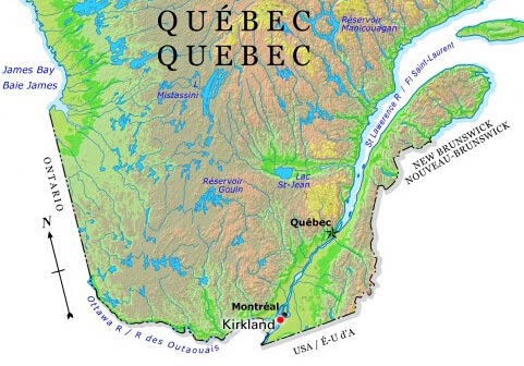
-
Article
Kirkland Lake
Kirkland Lake, Ont, incorporated as a town in 1972, population 8133 (2011c), 8248 (2006c). The Town of Kirkland Lake is located 241 km northwest of North Bay.
"https://development.thecanadianencyclopedia.ca/images/tce_placeholder.jpg?v=e9dca980c9bdb3aa11e832e7ea94f5d9" // resources/views/front/categories/view.blade.php
https://development.thecanadianencyclopedia.ca/images/tce_placeholder.jpg?v=e9dca980c9bdb3aa11e832e7ea94f5d9
-
Article
Kitchener-Waterloo
Kitchener, Ontario, incorporated as a city in 1912, population 256,885 (2021 census), 233,222 (2016 census). Waterloo, Ontario, incorporated as a city in 1948, population 121,436 (2021 census), 104,986 (2016 census). The twin cities of Kitchener-Waterloo are located in central southwestern Ontario, 105 km southwest of Toronto. Each retains its own political culture within a common historical framework and with similar, but by no means identical, socio-economic developments. Kitchener (originally named Berlin), the larger of the two, was the county seat (1853), judicial and financial centre of Waterloo County from 1853 to 1973. It continues to have a predominant influence in the Regional Municipality of Waterloo, which was formed in 1973 by combining several communities and cities, including Kitchener, Waterloo and Cambridge.
"https://d2ttikhf7xbzbs.cloudfront.net/media/media/936bad19-168e-4c98-a747-201f5eb2cefa.jpg" // resources/views/front/categories/view.blade.php
https://d2ttikhf7xbzbs.cloudfront.net/media/media/936bad19-168e-4c98-a747-201f5eb2cefa.jpg
-
Article
Kitimat
Kitimat, British Columbia, incorporated as a district municipality in 1953, population 8,236 (2021 census), 8,131 (2016 census). The district of Kitimat is located at the head of the Douglas Channel, 206 km east of Prince Rupert by road. Its name comes from the Tsimshian term for the Haisla inhabitants of the area, Kitamaat (“people of the snow”). The modern community was founded in the early 1950s.
"https://d2ttikhf7xbzbs.cloudfront.net/media/new_article_images/Kitimat/Kitimat_2008.jpg" // resources/views/front/categories/view.blade.php
https://d2ttikhf7xbzbs.cloudfront.net/media/new_article_images/Kitimat/Kitimat_2008.jpg
-
Article
Kitsilano
Kitsilano, a 549 ha waterfront section of VANCOUVER, incorporated into that city in 1886. It stretches south from English Bay to 16th Avenue and east from Alma to Burrard street.
"https://d2ttikhf7xbzbs.cloudfront.net/media/media/a1d97bef-a8f5-4fa4-89fe-aadf1c0107f6.jpg" // resources/views/front/categories/view.blade.php
https://d2ttikhf7xbzbs.cloudfront.net/media/media/a1d97bef-a8f5-4fa4-89fe-aadf1c0107f6.jpg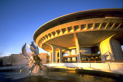
-
Article
Kleinburg
Kleinburg, Ont, straddles a hogback between 2 branches of the Humber River 40 km NW of Toronto. It has no legal entity, being part of the sprawling city of Vaughan (formerly Vaughan Township), and therefore no official boundaries. Founded around 1847 by an Alsatian immigrant, John Kline (sic), who built the first gristmill, it is known today as the site of one of Canada's largest art galleries, the McMichael Canadian Art Collection; for the Toronto...
"https://development.thecanadianencyclopedia.ca/images/tce_placeholder.jpg?v=e9dca980c9bdb3aa11e832e7ea94f5d9" // resources/views/front/categories/view.blade.php
https://development.thecanadianencyclopedia.ca/images/tce_placeholder.jpg?v=e9dca980c9bdb3aa11e832e7ea94f5d9
-
Article
Klondike
Klondike (also spelled Klondyke). The name is derived from a Gwich'in word, thron-duick (hammer river), and identifies a town, a river, and a range of hills in the Yukon.
"https://development.thecanadianencyclopedia.ca/images/tce_placeholder.jpg?v=e9dca980c9bdb3aa11e832e7ea94f5d9" // resources/views/front/categories/view.blade.php
https://development.thecanadianencyclopedia.ca/images/tce_placeholder.jpg?v=e9dca980c9bdb3aa11e832e7ea94f5d9
-
Article
Ksan
Ksan (or ‘Ksan) is a historical village, museum and campground, owned and operated by the Gitanmaax Band. It is located at the junction of the Skeena and Bulkley rivers in Hazelton, British Columbia. Ksan was established in 1970 as way to promote and preserve Gitxsan culture and history.
"https://d2ttikhf7xbzbs.cloudfront.net/media/media/2fd73ae3-5ed7-4894-b6ae-caa2ac25e639.jpg" // resources/views/front/categories/view.blade.php
https://d2ttikhf7xbzbs.cloudfront.net/media/media/2fd73ae3-5ed7-4894-b6ae-caa2ac25e639.jpg
-
Article
Kugaaruk
Kugaaruk, Nunavut, incorporated as a hamlet in 1972, population 771 (2011c), 688 (2006c). The Hamlet of Kugaaruk is located in the northeastern Arctic on the coast within Pelly Bay
"https://development.thecanadianencyclopedia.ca/images/tce_placeholder.jpg?v=e9dca980c9bdb3aa11e832e7ea94f5d9" // resources/views/front/categories/view.blade.php
https://development.thecanadianencyclopedia.ca/images/tce_placeholder.jpg?v=e9dca980c9bdb3aa11e832e7ea94f5d9
-
Article
Kugluktuk
Kugluktuk, Nunavut, incorporated as a hamlet in 1981, population 1,491 (2016 census), population 1,450 (2011 census). The Hamlet of Kugluktuk, formerly known as Coppermine, is situated west of the mouth of the Coppermine River on the mainland Arctic coast. The hamlet changed its name in 1996 to Kugluktuk, which means "place of rapids," referring to the rapids at Bloody Falls, 15 km upstream.
"https://development.thecanadianencyclopedia.ca/images/tce_placeholder.jpg?v=e9dca980c9bdb3aa11e832e7ea94f5d9" // resources/views/front/categories/view.blade.php
https://development.thecanadianencyclopedia.ca/images/tce_placeholder.jpg?v=e9dca980c9bdb3aa11e832e7ea94f5d9
-
Article
La Baie
La Baie was founded in 1838 by employees of the Société des Vingt-et-un, a Charlevoix forestry company bought by William Price in 1842. Price's sawmills were soon joined by port facilities, making La Baie, a natural harbour, a major port on the Atlantic coast.
"https://development.thecanadianencyclopedia.ca/images/tce_placeholder.jpg?v=e9dca980c9bdb3aa11e832e7ea94f5d9" // resources/views/front/categories/view.blade.php
https://development.thecanadianencyclopedia.ca/images/tce_placeholder.jpg?v=e9dca980c9bdb3aa11e832e7ea94f5d9
-
Article
La Loche
The NORTH WEST COMPANY had a post at the Portage as early as 1808 and the HUDSON'S BAY COMPANY soon followed suit. Here the Athabasca and Mackenzie River brigades exchanged goods and furs with the La Loche brigade.
"https://development.thecanadianencyclopedia.ca/images/tce_placeholder.jpg?v=e9dca980c9bdb3aa11e832e7ea94f5d9" // resources/views/front/categories/view.blade.php
https://development.thecanadianencyclopedia.ca/images/tce_placeholder.jpg?v=e9dca980c9bdb3aa11e832e7ea94f5d9