Browse "Cities & Populated Places"
-
Article
La Malbaie
La Malbaie, Quebec, incorporated as a town in 1999, pop 8,235 (2021 census), 8,271 (2016 census). La Malbaie is situated on the lower north shore of the St. Lawrence River at the mouth of Rivière Malbaie, 150 km east of Quebec City. The town is the result of two mergers. The first occurred in 1995 and involved La Malbaie (incorporated as a town in 1958) and Pointe-au-Pic (village, 1876). Four years later, Rivière-Malbaie (town, 1938), Saint-Fidèle (town, 1997), Cap-à-l'Aigle (village, 1916) and Sainte-Agnès (parish municipality, 1855) were included.
"https://d2ttikhf7xbzbs.cloudfront.net/media/media/e8e68977-8038-4c47-8ee4-2970a6e433c3.jpg" // resources/views/front/categories/view.blade.php
https://d2ttikhf7xbzbs.cloudfront.net/media/media/e8e68977-8038-4c47-8ee4-2970a6e433c3.jpg
-
Article
Montreal's Little Italy
The product of two major Italian immigration cohorts to Canada (one from 1880 until the First World War, and the other from 1950 to 1970), Montreal’s Italian Canadian community has been gathering in the Notre-Dame-de-la-Défense parish since 1910. This neighbourhood, nestled within the Rosemont-La Petite-Patrie borough, is located along Saint-Laurent Boulevard, with Saint-Zotique and Jean-Talon streets marking its limits. Always at the heart of Italian-Canadian community and cultural life in Montreal, Little Italy (Piccola Italia) is known for its buildings’ remarkable architecture and decor. It is also home to a true institution of Montreal’s cityscape: the Jean‑Talon Market.
"https://d2ttikhf7xbzbs.cloudfront.net/media/media/b11aa219-9b12-4d95-a4b5-29522e0bbbf8.JPG" // resources/views/front/categories/view.blade.php
https://d2ttikhf7xbzbs.cloudfront.net/media/media/b11aa219-9b12-4d95-a4b5-29522e0bbbf8.JPG
-
Article
La Pocatière
In 1672, François Pollet de La Combe-Pocatière received the seigneurie de la Grande-Anse as a gift from his father-in-law, Nicholas Juchereau de Saint-Denys. This territory became the parish of Ste-Anne-de-La-Pocatière, and later, the city of La Pocatière.
"https://d2ttikhf7xbzbs.cloudfront.net/media/media/b102f2b5-4d17-48f9-a9d0-64c5fb825bac.jpg" // resources/views/front/categories/view.blade.php
https://d2ttikhf7xbzbs.cloudfront.net/media/media/b102f2b5-4d17-48f9-a9d0-64c5fb825bac.jpg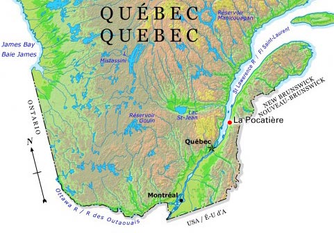
-
Article
La Prairie
In 1836 the first Canadian railway, linking La Prairie with Saint-Jean, was inaugurated. After construction of the Victoria Bridge, goods trains coming from the east were diverted from the town.
"https://development.thecanadianencyclopedia.ca/images/tce_placeholder.jpg?v=e9dca980c9bdb3aa11e832e7ea94f5d9" // resources/views/front/categories/view.blade.php
https://development.thecanadianencyclopedia.ca/images/tce_placeholder.jpg?v=e9dca980c9bdb3aa11e832e7ea94f5d9
-
Article
La Ronge
Occupation of the present townsite started when Archdeacon John Alexander Mackay established a residential school and sawmill (1898). Not accessible by road until 1947, the largely Indigenous community grew very slowly for many years.
"https://development.thecanadianencyclopedia.ca/images/tce_placeholder.jpg?v=e9dca980c9bdb3aa11e832e7ea94f5d9" // resources/views/front/categories/view.blade.php
https://development.thecanadianencyclopedia.ca/images/tce_placeholder.jpg?v=e9dca980c9bdb3aa11e832e7ea94f5d9
-
Article
La Sarre
HistoryFounded in 1917, it was one of the first agricultural centres to be settled when the transcontinental railway opened up the Abitibi region around 1910.
"https://development.thecanadianencyclopedia.ca/images/tce_placeholder.jpg?v=e9dca980c9bdb3aa11e832e7ea94f5d9" // resources/views/front/categories/view.blade.php
https://development.thecanadianencyclopedia.ca/images/tce_placeholder.jpg?v=e9dca980c9bdb3aa11e832e7ea94f5d9
-
Article
La Tuque
La Tuque, Quebec, incorporated 1911, population 11,001 (2016 census), 11,227 (2011 census). La Tuque is located on the Rivière Saint-Maurice, 165 km north of Trois-Rivières. The town was built at the start of the 20th century at the site of a former trading post. It owes its name to a mountain shaped like a triangular woolen hat, popularly known as a “tuque.” The town’s economy is driven in large part by the forestry industry.
"https://development.thecanadianencyclopedia.ca/images/tce_placeholder.jpg?v=e9dca980c9bdb3aa11e832e7ea94f5d9" // resources/views/front/categories/view.blade.php
https://development.thecanadianencyclopedia.ca/images/tce_placeholder.jpg?v=e9dca980c9bdb3aa11e832e7ea94f5d9
-
Article
Labrador City
Labrador City, Newfoundland and Labrador, incorporated as a town in 1961, population 7,220 (2016 census), 7,367 (2011 census). The Town of Labrador City is in western Labrador near the Quebec border.
"https://development.thecanadianencyclopedia.ca/images/tce_placeholder.jpg?v=e9dca980c9bdb3aa11e832e7ea94f5d9" // resources/views/front/categories/view.blade.php
https://development.thecanadianencyclopedia.ca/images/tce_placeholder.jpg?v=e9dca980c9bdb3aa11e832e7ea94f5d9
-
Article
Lac-Beauport
In the early 1800s the territory was opened up to exploit the forest resources. By the early 1820s the area around Lac Beauport was known as Waterloo Settlement. The first settlers were of English origin. In 1853 the parish municipality of Saint-Dunstan-du-Lac-Beauport was created.
"https://d2ttikhf7xbzbs.cloudfront.net/media/media/c17053a3-9a95-4ba1-8032-8c965bb82fee.jpg" // resources/views/front/categories/view.blade.php
https://d2ttikhf7xbzbs.cloudfront.net/media/media/c17053a3-9a95-4ba1-8032-8c965bb82fee.jpg
-
Article
Lac du Bonnet
Lac du Bonnet, Manitoba, incorporated as a rural municipality in 1917, population 2671 (2011c), 2812 (2006c). The Rural Municipality of Lac du Bonnet is located 100 km northeast of Winnipeg on Lac du Bonnet
"https://d2ttikhf7xbzbs.cloudfront.net/media/media/10511603-ff9a-4cd8-821c-641bba0ee988.jpg" // resources/views/front/categories/view.blade.php
https://d2ttikhf7xbzbs.cloudfront.net/media/media/10511603-ff9a-4cd8-821c-641bba0ee988.jpg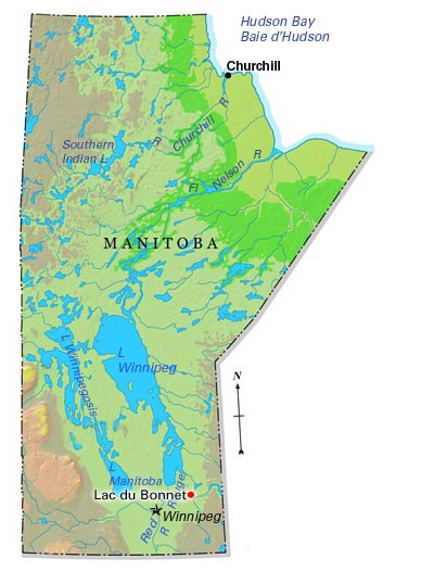
-
Article
Lac La Biche
Lac La Biche, Alberta, incorporated as a municipal district in 2007, population 7,673 (2021 census), 8,330 (2016 census). Lac La Biche County is located 225 km northeast of Edmonton on the south shore of the lake of the same name. Incorporated as a town in 1951, Lac La Biche amalgamated with Lakeland County in 2007 to create Lac La Biche County.
"https://development.thecanadianencyclopedia.ca/images/tce_placeholder.jpg?v=e9dca980c9bdb3aa11e832e7ea94f5d9" // resources/views/front/categories/view.blade.php
https://development.thecanadianencyclopedia.ca/images/tce_placeholder.jpg?v=e9dca980c9bdb3aa11e832e7ea94f5d9
-
Article
Lac-Mégantic (town)
Lac-Mégantic, Quebec was incorporated as a town in 1907, population 5,747 (2021 census), 5,654 (2016 census). Located in Estrie in the Regional County Municipality of Le Granit, the town of Lac-Mégantic is situated approximately 95 km east of Sherbrooke on the northeast shore of Lac Mégantic (see Eastern Townships). The town is Le Granit’s centre of industry (lumber and granite), administration and commerce. On 6 July 2013, a devastating train derailment occurred in Lac-Mégantic (see Lac-Mégantic Rail Disaster; Railway Disasters).
"https://d2ttikhf7xbzbs.cloudfront.net/media/media/0ba32689-d18b-4fa5-924f-8d7008f7ca20.jpg" // resources/views/front/categories/view.blade.php
https://d2ttikhf7xbzbs.cloudfront.net/media/media/0ba32689-d18b-4fa5-924f-8d7008f7ca20.jpg
-
Article
Lachenaie
The old agricultural settlement dates back to 1672 when the first colonists arrived. Its history is steeped in the FUR TRADE. La Chesnaye was involved in the fur trade as were Jacob Jordan (1741-96) and Nor'wester Peter Pangman (1744-1819), 2 of the last seigneurs in the late 18th century.
"https://development.thecanadianencyclopedia.ca/images/tce_placeholder.jpg?v=e9dca980c9bdb3aa11e832e7ea94f5d9" // resources/views/front/categories/view.blade.php
https://development.thecanadianencyclopedia.ca/images/tce_placeholder.jpg?v=e9dca980c9bdb3aa11e832e7ea94f5d9
-
Article
Lachine
The development of the Lachine Canal in the 1820s, the establishment of the Montreal and Lachine Railroad in 1847, and the expansion of the trucking business in the 20th century gave Lachine a major role in the trade network extending to southwestern Canada and the US.
"https://development.thecanadianencyclopedia.ca/images/tce_placeholder.jpg?v=e9dca980c9bdb3aa11e832e7ea94f5d9" // resources/views/front/categories/view.blade.php
https://development.thecanadianencyclopedia.ca/images/tce_placeholder.jpg?v=e9dca980c9bdb3aa11e832e7ea94f5d9
-
Article
Lachute
Agriculture sustained the early settlers, but the town developed through its close connection with the paper and textile industries.
"https://development.thecanadianencyclopedia.ca/images/tce_placeholder.jpg?v=e9dca980c9bdb3aa11e832e7ea94f5d9" // resources/views/front/categories/view.blade.php
https://development.thecanadianencyclopedia.ca/images/tce_placeholder.jpg?v=e9dca980c9bdb3aa11e832e7ea94f5d9