Browse "Cities & Populated Places"
-
Article
Maple Ridge
Maple Ridge, BC, incorporated as a district municipality in 1874, population 76 052 (2011c), 68 949 (2006c). The District of Maple Ridge is located 40 km east of VANCOUVER, bounded by the FRASER RIVER on the south and on the north by the Golden Ears Mountain.
"https://development.thecanadianencyclopedia.ca/images/tce_placeholder.jpg?v=e9dca980c9bdb3aa11e832e7ea94f5d9" // resources/views/front/categories/view.blade.php
https://development.thecanadianencyclopedia.ca/images/tce_placeholder.jpg?v=e9dca980c9bdb3aa11e832e7ea94f5d9
-
Article
Markham
Markham, Ontario, incorporated as a city in 1971, population 338,503 (2021 census), 328,966 (2016 census). Markham is located immediately northeast of Toronto. It is one of nine municipalities that make up the Regional Municipality of York. The Rouge River cuts through the municipality diagonally, connecting to Rouge National Urban Park. Initially an agricultural community, Markham is now known for its technology businesses and ethnocultural diversity. Throughout history, the Markham area has been home to different Indigenous groups, namely the Huron Wendat, Haudenosaunee and Anishinaabeg. The land is covered by Treaty 13 and the Williams Treaties.
"https://d2ttikhf7xbzbs.cloudfront.net/media/new_article_images/Markham/PacificMall.jpg" // resources/views/front/categories/view.blade.php
https://d2ttikhf7xbzbs.cloudfront.net/media/new_article_images/Markham/PacificMall.jpg
-
Article
Marshall
Marshall, Sask, incorporated as a village in 1914 and as a town in 2006, population 533 (2011c), 608 (2006c). The Town of Marshall is located on the Canadian National Railway line and the Yellowhead Highway between LLOYDMINSTER and NORTH BATTLEFORD, in the Rural Municipality of WILTON.
"https://development.thecanadianencyclopedia.ca/images/tce_placeholder.jpg?v=e9dca980c9bdb3aa11e832e7ea94f5d9" // resources/views/front/categories/view.blade.php
https://development.thecanadianencyclopedia.ca/images/tce_placeholder.jpg?v=e9dca980c9bdb3aa11e832e7ea94f5d9
-
Article
Martensville
Martensville, Sask, incorporated as a town in 1969 and a city in 2009, population 7716 (2011c), 4978 (2006c). The City of Martensville is located 9 km north of SASKATOON. In the late 1960s as Saskatoon's population underwent
"https://development.thecanadianencyclopedia.ca/images/tce_placeholder.jpg?v=e9dca980c9bdb3aa11e832e7ea94f5d9" // resources/views/front/categories/view.blade.php
https://development.thecanadianencyclopedia.ca/images/tce_placeholder.jpg?v=e9dca980c9bdb3aa11e832e7ea94f5d9
-
Article
Marystown
Marystown, NL, incorporated as a town in 1951, population 5506 (2011c), 5436 (2006c). The Town of Marystown is a shipbuilding and fish-processing centre, comprising the settlements of Marystown (formerly Mortier Bay), Creston, Creston North, Little Bay and Mooring Cove on the east side of the Burin Peninsula.
"https://development.thecanadianencyclopedia.ca/images/tce_placeholder.jpg?v=e9dca980c9bdb3aa11e832e7ea94f5d9" // resources/views/front/categories/view.blade.php
https://development.thecanadianencyclopedia.ca/images/tce_placeholder.jpg?v=e9dca980c9bdb3aa11e832e7ea94f5d9
-
Article
Mascouche
The history of Mascouche was closely linked to the roles played by Gabriel Christie and Peter and his son John Pangman, 3 of the last owners of the Seigneury de La Chesnaye.
"https://development.thecanadianencyclopedia.ca/images/tce_placeholder.jpg?v=e9dca980c9bdb3aa11e832e7ea94f5d9" // resources/views/front/categories/view.blade.php
https://development.thecanadianencyclopedia.ca/images/tce_placeholder.jpg?v=e9dca980c9bdb3aa11e832e7ea94f5d9
-
Article
Masset
Masset, BC, incorporated as a village in 1961, population 884 (2011c), 940 (2006c). The Village of Masset is located on the northern tip of Graham Island, the largest of HAIDA GWAII off the northern coast of British Columbia.
"https://development.thecanadianencyclopedia.ca/images/tce_placeholder.jpg?v=e9dca980c9bdb3aa11e832e7ea94f5d9" // resources/views/front/categories/view.blade.php
https://development.thecanadianencyclopedia.ca/images/tce_placeholder.jpg?v=e9dca980c9bdb3aa11e832e7ea94f5d9
-
Article
Masson-Angers
Masson-Angers is both industrial and residential in character. The main employer is the James MacLaren Industries pulp and paper mill, dating back to 1932. Hundreds of residents also work as civil servants for the federal government, commuting daily to and from the Ottawa-Hull area.
"https://d2ttikhf7xbzbs.cloudfront.net/media/media/4bf886be-b0b6-46fe-a3c4-8821edf34d6c.jpg" // resources/views/front/categories/view.blade.php
https://d2ttikhf7xbzbs.cloudfront.net/media/media/4bf886be-b0b6-46fe-a3c4-8821edf34d6c.jpg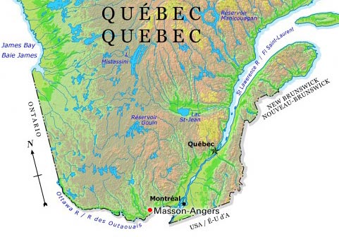
-
Article
Matane
In the 1950s, the closing of several paper mills resulted in widespread unemployment. A decade later, however, the recognition of Matane's port as an important regional transportation and distribution point revived interest in the town. There is now a pulp mill and a paper mill providing employment.
"https://development.thecanadianencyclopedia.ca/images/tce_placeholder.jpg?v=e9dca980c9bdb3aa11e832e7ea94f5d9" // resources/views/front/categories/view.blade.php
https://development.thecanadianencyclopedia.ca/images/tce_placeholder.jpg?v=e9dca980c9bdb3aa11e832e7ea94f5d9
-
Article
Black River-Matheson
Black River-Matheson, Ontario, incorporated as a township in 1969, population 2,572 (2021 census), 2,438 (2016 census). Black River-Matheson is located 296 km northwest of North Bay.
"https://d2ttikhf7xbzbs.cloudfront.net/blackrivermatheson/Matheson-Station.jpg" // resources/views/front/categories/view.blade.php
https://d2ttikhf7xbzbs.cloudfront.net/blackrivermatheson/Matheson-Station.jpg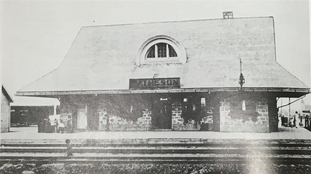
-
Article
Matsqui
Matsqui, BC, Urban Community, was a district municipality (1892-1995) until it was merged with the District Municipality of Abbotsford to form the city of ABBOTSFORD. Matsqui is located between the FRASER RIVER (opposite the district of MISSION) and the US border.
"https://development.thecanadianencyclopedia.ca/images/tce_placeholder.jpg?v=e9dca980c9bdb3aa11e832e7ea94f5d9" // resources/views/front/categories/view.blade.php
https://development.thecanadianencyclopedia.ca/images/tce_placeholder.jpg?v=e9dca980c9bdb3aa11e832e7ea94f5d9
-
Article
Mayo
In 1919 the discovery of silver-lead deposits at KENO HILL transformed Mayo into a major transshipment point for ore. In 1950 a road was built to the Klondike Highway, but as the riverboats went out of service, Mayo declined.
"https://development.thecanadianencyclopedia.ca/images/tce_placeholder.jpg?v=e9dca980c9bdb3aa11e832e7ea94f5d9" // resources/views/front/categories/view.blade.php
https://development.thecanadianencyclopedia.ca/images/tce_placeholder.jpg?v=e9dca980c9bdb3aa11e832e7ea94f5d9
-
Article
McAdam
McAdam, NB, incorporated as a village in1966, population 1284 (2011c), 1404 (2006c). The Village of McAdam is located in York County, in the Appalachian Highlands region of southwestern New Brunswick, 10 km from the Canada/US border.
"https://development.thecanadianencyclopedia.ca/images/tce_placeholder.jpg?v=e9dca980c9bdb3aa11e832e7ea94f5d9" // resources/views/front/categories/view.blade.php
https://development.thecanadianencyclopedia.ca/images/tce_placeholder.jpg?v=e9dca980c9bdb3aa11e832e7ea94f5d9
-
Article
Meadow Lake
During the 1930s many farmers deserted land in the "dust bowl" and moved N to start again. Meadow Lake was a popular destination, and the arrival of a CPR line in 1936 provided an opportunity for further development.
"https://development.thecanadianencyclopedia.ca/images/tce_placeholder.jpg?v=e9dca980c9bdb3aa11e832e7ea94f5d9" // resources/views/front/categories/view.blade.php
https://development.thecanadianencyclopedia.ca/images/tce_placeholder.jpg?v=e9dca980c9bdb3aa11e832e7ea94f5d9
-
Article
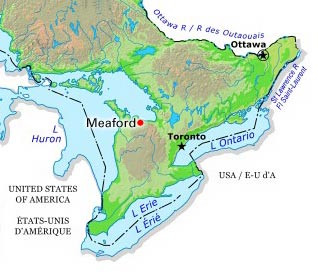
Meaford
Meaford, Ont, incorporated as a municipality in 2001, population 11 100 (2011c) 10 948 (2006c). The Municipality of Meaford was a town (incorporated in 1874) until 2001 when it was amalgamated with St Vincent and Sydenham townships to create the Municipality of Meaford
"https://d2ttikhf7xbzbs.cloudfront.net/media/media/2fa20b37-d822-4528-b9b5-d99acf454bfc.jpg" // resources/views/front/categories/view.blade.php
https://d2ttikhf7xbzbs.cloudfront.net/media/media/2fa20b37-d822-4528-b9b5-d99acf454bfc.jpg