Browse "Cities & Populated Places"
-
Article
Nipawin
Nipawin is situated at a point on the Saskatchewan River where the prairie and woodland meet. It also lies between 2 lakes (Tobin, 1963 and Codette, 1986) that are the result of hydroelectricity development on the river.
"https://development.thecanadianencyclopedia.ca/images/tce_placeholder.jpg?v=e9dca980c9bdb3aa11e832e7ea94f5d9" // resources/views/front/categories/view.blade.php
https://development.thecanadianencyclopedia.ca/images/tce_placeholder.jpg?v=e9dca980c9bdb3aa11e832e7ea94f5d9
-
Article
Niverville
Niverville, Manitoba, incorporated as a town in 1993, population 3540 (2011c), 2464 (2006c). The Town of Niverville is located 40 km south of Winnipeg.
"https://d2ttikhf7xbzbs.cloudfront.net/media/media/1c001a0e-d166-4498-9c92-afec11f0a146.jpg" // resources/views/front/categories/view.blade.php
https://d2ttikhf7xbzbs.cloudfront.net/media/media/1c001a0e-d166-4498-9c92-afec11f0a146.jpg
-
Article
Norfolk County
Norfolk County, Ont, incorporated as a city in 2001, population 63 175 (2011c), 62 563 (2006c). The City of Norfolk County is located 56 km southwest of Hamilton and 97 km southeast of London.
"https://d2ttikhf7xbzbs.cloudfront.net/media/media/6928ba8e-68f0-4309-a242-259e8cc1000b.jpg" // resources/views/front/categories/view.blade.php
https://d2ttikhf7xbzbs.cloudfront.net/media/media/6928ba8e-68f0-4309-a242-259e8cc1000b.jpg
-
Article
Norman Wells
Norman Wells, Northwest Territories, incorporated as a town in 1992, population 673 (2021 census), 778 (2016 census). The town of Norman Wells is located on the north bank of the Mackenzie River, 145 km south of the Arctic Circle and 684 km northwest of Yellowknife by air. It was the first settlement in the Northwest Territories founded entirely as a result of non-renewable-resource development. The name owes to the site’s close proximity to Fort Norman (now Tulita), 85 km upstream on the Mackenzie.
"https://development.thecanadianencyclopedia.ca/images/tce_placeholder.jpg?v=e9dca980c9bdb3aa11e832e7ea94f5d9" // resources/views/front/categories/view.blade.php
https://development.thecanadianencyclopedia.ca/images/tce_placeholder.jpg?v=e9dca980c9bdb3aa11e832e7ea94f5d9
-
Article
Normandin
On 14 February 1979, the city of Normandin was created by the amalgamation of the village of Normandin and the parish of Normandin. However, its history began on 23 May 1733 when Joseph-Laurent Normandin was sent to survey this region and prepare a map of the lakes and rivers.
"https://d2ttikhf7xbzbs.cloudfront.net/media/media/7ada88f5-5e3d-400d-8c7d-a85dc4d72e8c.jpg" // resources/views/front/categories/view.blade.php
https://d2ttikhf7xbzbs.cloudfront.net/media/media/7ada88f5-5e3d-400d-8c7d-a85dc4d72e8c.jpg
-
Article
North Battleford
A new town site, named North Battleford, was laid out in 1905. The community grew rapidly with many businesses and residents abandoning the older community and moving to the new rail centre. By 1913 North Battleford was granted city status.
"https://development.thecanadianencyclopedia.ca/images/tce_placeholder.jpg?v=e9dca980c9bdb3aa11e832e7ea94f5d9" // resources/views/front/categories/view.blade.php
https://development.thecanadianencyclopedia.ca/images/tce_placeholder.jpg?v=e9dca980c9bdb3aa11e832e7ea94f5d9
-
Article
North Bay
North Bay, Ontario, incorporated as a city in 1925, population 51,553 (2016 census), 53,651 (2011 census). North Bay is located on a northeastern bay of Lake Nipissing, at the junction of highways 11 and 17, some 345 km north of Toronto and 365 km northwest of Ottawa. As the traditional "Gateway to the North," the city is the administrative seat for the District of Nipissing.
"https://d2ttikhf7xbzbs.cloudfront.net/media/media/feb55fdc-51a1-4214-8a4a-5f5c61e98a6d.jpg" // resources/views/front/categories/view.blade.php
https://d2ttikhf7xbzbs.cloudfront.net/media/media/feb55fdc-51a1-4214-8a4a-5f5c61e98a6d.jpg
-
Article
North Cowichan
North Cowichan, BC, incorporated as a district municipality in 1873, population 28 807 (2011c), 27 557 (2006c). The Municipality of North Cowichan is located on the east coast of VANCOUVER ISLAND about halfway between Nanaimo and Victoria.
"https://d2ttikhf7xbzbs.cloudfront.net/media/media/ce2915be-f93b-4a88-b0e0-316d5c6a246f.jpg" // resources/views/front/categories/view.blade.php
https://d2ttikhf7xbzbs.cloudfront.net/media/media/ce2915be-f93b-4a88-b0e0-316d5c6a246f.jpg
-
Article
North Saanich
North Saanich, BC, incorporated as a district municipality in 1965, population 11 089 (2011c), 10 823 (2006c). The District of North Saanich is one of three district municipalities on the Saanich Peninsula about 27 km north of Victoria.
"https://d2ttikhf7xbzbs.cloudfront.net/media/media/dee732ba-3897-4661-8537-d19601c1bfee.jpg" // resources/views/front/categories/view.blade.php
https://d2ttikhf7xbzbs.cloudfront.net/media/media/dee732ba-3897-4661-8537-d19601c1bfee.jpg
-
Article
North Vancouver
North Vancouver, British Columbia, incorporated as a district in 1891, population 85,935 (2016 census), 84,412 (2011 census); also, a separate entity incorporated as a city in 1907, population 52,898 (2016 census), 48,196 (2011 census). The district of North Vancouver and the city of North Vancouver are located in southwestern British Columbia, adjacent to the city of Vancouver. Situated on the north shore of Burrard Inlet, North Vancouver extends from the Capilano River on the west to beyond Deep Cove on the east. The district surrounds the city, which is centered on Lonsdale Avenue, except at the waterfront. Elevations in North Vancouver range from sea level to 1,400 metres. The North Shore mountains — such as Grouse and Seymour — form a scenic backdrop.
"https://d2ttikhf7xbzbs.cloudfront.net/media/new_article_images/NorthVancouver/North Vancouver_2016.jpg" // resources/views/front/categories/view.blade.php
https://d2ttikhf7xbzbs.cloudfront.net/media/new_article_images/NorthVancouver/North Vancouver_2016.jpg
-
Article
North-West Territories (1870–1905)
The North-West Territories was the first Canadian territory. It was Established on 15 July 1870. As a territory, the region became part of Canada. But it lacked the population, economic and infrastructure resources to attain provincial status. It thus fell under the jurisdiction of the federal government. It covered a vast area, stretching west from a disputed boundary with Labrador, across the northern portions of present-day Quebec and Ontario, through the Prairies to British Columbia, and north from the 49th parallel to the Arctic Ocean. The territory was subject to numerous boundary changes before 1905. At that time, the provinces of Saskatchewan and Alberta were carved out of the southwest portion of the region. In 1906, the remaining territory was renamed the Northwest Territories.
"https://d2ttikhf7xbzbs.cloudfront.net/media/media/1ca2e02a-e2e8-4709-acee-5581d6051d5c.jpg" // resources/views/front/categories/view.blade.php
https://d2ttikhf7xbzbs.cloudfront.net/media/media/1ca2e02a-e2e8-4709-acee-5581d6051d5c.jpg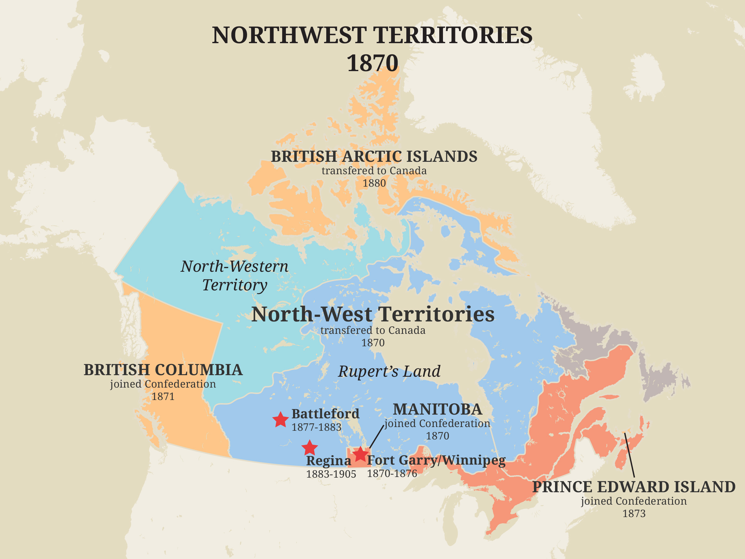
-
Article
North York
North York, Ontario, Urban Community within the city of Toronto. North York was a city (incorporated from 1979 to 1998) until it was amalgamated into the new megacity of TORONTO in 1998.
"https://d2ttikhf7xbzbs.cloudfront.net/media/media/c23a342f-ed21-417e-896b-1565a1f1be1b.jpg" // resources/views/front/categories/view.blade.php
https://d2ttikhf7xbzbs.cloudfront.net/media/media/c23a342f-ed21-417e-896b-1565a1f1be1b.jpg
-
Article
Notre Dame de Lourdes
Notre Dame de Lourdes, Manitoba, incorporated as a village in 1963, population 683 (2011c), 589 (2006c). The Village of Notre Dame de Lourdes is situated on the northeast slope of the Pembina Hills, 130 km southwest of WINNIPEG.
"https://development.thecanadianencyclopedia.ca/images/tce_placeholder.jpg?v=e9dca980c9bdb3aa11e832e7ea94f5d9" // resources/views/front/categories/view.blade.php
https://development.thecanadianencyclopedia.ca/images/tce_placeholder.jpg?v=e9dca980c9bdb3aa11e832e7ea94f5d9
-
Article
Nova Scotia and Confederation
Nova Scotia was one of the four founding provinces of Canada. It joined New Brunswick, Ontario and Quebec in Confederation on 1 July 1867. However, this was mainly because Confederation delivered the Intercolonial Railway to the Maritimes, and because of the efforts of Sir Charles Tupper. His government passed approval for Confederation in the colonial legislature despite popular opposition. (See Confederation’s Opponents.) Confederation was met with mass protests in the colony. Joseph Howe led a two-year effort to repeal the union. (See Repeal Movement.) But Howe finally decided he could do more to help his province by working inside the federal government. He joined the federal Cabinet in 1869.
"https://d2ttikhf7xbzbs.cloudfront.net/media/media/7b457631-bb6e-40ee-bf61-fab12a06fb6d.jpg" // resources/views/front/categories/view.blade.php
https://d2ttikhf7xbzbs.cloudfront.net/media/media/7b457631-bb6e-40ee-bf61-fab12a06fb6d.jpg
-
Article
Oak Bay
Oak Bay, incorporated as a district municipality in 1906, population 18 015 (2011c), 17 908 (2006c). The District of Oak Bay is located on the southeast corner of VANCOUVER ISLAND, adjoining the city of VICTORIA. It is surrounded by JUAN DE FUCA STRAIT on the south and Haro Strait on the east.
"https://development.thecanadianencyclopedia.ca/images/tce_placeholder.jpg?v=e9dca980c9bdb3aa11e832e7ea94f5d9" // resources/views/front/categories/view.blade.php
https://development.thecanadianencyclopedia.ca/images/tce_placeholder.jpg?v=e9dca980c9bdb3aa11e832e7ea94f5d9