Browse "Cities & Populated Places"
-
Article
Rossland
Rossland, BC, incorporated as a city in 1897, population 4,140 (2021 census), 3,729 (2016 census). The City of Rossland is located 10 km southwest of Trail in the eroded crater of a long-extinct volcano of the Monashee Mountains.
"https://development.thecanadianencyclopedia.ca/images/tce_placeholder.jpg?v=e9dca980c9bdb3aa11e832e7ea94f5d9" // resources/views/front/categories/view.blade.php
https://development.thecanadianencyclopedia.ca/images/tce_placeholder.jpg?v=e9dca980c9bdb3aa11e832e7ea94f5d9
-
Article
Rosthern
In 1891 and 1892 a group of Mennonite farmers, several from the Manitoba settlements, arrived in the area. Dr Seager WHEELER, a pioneer in scientific agriculture, had his farm in the area; it is now a national historic site.
"https://d2ttikhf7xbzbs.cloudfront.net/media/media/3aaaa54e-d3b3-45f2-97e7-ffa1b1d5118d.jpg" // resources/views/front/categories/view.blade.php
https://d2ttikhf7xbzbs.cloudfront.net/media/media/3aaaa54e-d3b3-45f2-97e7-ffa1b1d5118d.jpg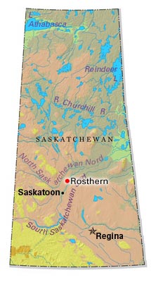
-
Article
Rothesay
Rothesay, NB, incorporated as a town in 1998, population 11 947 (2011c), 11 637 (2006c). It is situated on the eastern side of the Kennebecasis River, 22 km northeast of Saint John.
"https://development.thecanadianencyclopedia.ca/images/tce_placeholder.jpg?v=e9dca980c9bdb3aa11e832e7ea94f5d9" // resources/views/front/categories/view.blade.php
https://development.thecanadianencyclopedia.ca/images/tce_placeholder.jpg?v=e9dca980c9bdb3aa11e832e7ea94f5d9
-
Article
Rouyn-Noranda
Rouyn-Noranda, Qué, City, pop 28 270 (2001c), 30 936 A (1996c), 28 958 (1991c), area 348.07 km2, inc 1986, is the largest centre in the Abitibi-Témiscaming region and its administrative capital.
"https://development.thecanadianencyclopedia.ca/images/tce_placeholder.jpg?v=e9dca980c9bdb3aa11e832e7ea94f5d9" // resources/views/front/categories/view.blade.php
https://development.thecanadianencyclopedia.ca/images/tce_placeholder.jpg?v=e9dca980c9bdb3aa11e832e7ea94f5d9
-
Article
Russell (Man)
Russell, Manitoba, incorporated as a village in 1907 and as a town in 1913, population 1669 (2011c), 1590 (2006c). The Town of Russell is an agricultural service centre 350 km northwest of Winnipeg near the Manitoba-Saskatchewan border.
"https://development.thecanadianencyclopedia.ca/images/tce_placeholder.jpg?v=e9dca980c9bdb3aa11e832e7ea94f5d9" // resources/views/front/categories/view.blade.php
https://development.thecanadianencyclopedia.ca/images/tce_placeholder.jpg?v=e9dca980c9bdb3aa11e832e7ea94f5d9
-
Article
Russell (Ont)
Russell, Ontario, incorporated as a township in 1854, population 16,520 (2016 census), 15,247 (2011 census). The Township of Russell is located 33 km southeast of Ottawa. It was named after Peter Russell, an official in the government of Upper Canada.
"https://development.thecanadianencyclopedia.ca/images/tce_placeholder.jpg?v=e9dca980c9bdb3aa11e832e7ea94f5d9" // resources/views/front/categories/view.blade.php
https://development.thecanadianencyclopedia.ca/images/tce_placeholder.jpg?v=e9dca980c9bdb3aa11e832e7ea94f5d9
-
Article
Saanich
Saanich, BC, incorporated as a district municipality in 1906, population 109 752 (2011c), 108 265 (2006c). The District of Saanich is located immediately northwest of the city of VICTORIA, and is an integral part of the Greater Victoria area.
"https://d2ttikhf7xbzbs.cloudfront.net/media/media/8eb263da-d26b-4197-b26c-936471f19fe6.jpg" // resources/views/front/categories/view.blade.php
https://d2ttikhf7xbzbs.cloudfront.net/media/media/8eb263da-d26b-4197-b26c-936471f19fe6.jpg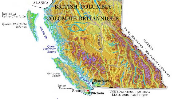
-
Article
Sackville
Sackville, NB, incorporated as a town in 1903, population 5558 (2011c), 5411 (2006c). Sackville is situated 50 km southeast of Moncton on the Tantramar River, near the Nova Scotia border.
"https://d2ttikhf7xbzbs.cloudfront.net/media/media/5dbfbca9-4ef2-40d8-b045-723f078917dd.jpg" // resources/views/front/categories/view.blade.php
https://d2ttikhf7xbzbs.cloudfront.net/media/media/5dbfbca9-4ef2-40d8-b045-723f078917dd.jpg
-
Article
Saint Andrews (NB)
Saint Andrews, NB, incorporated as a town in 1903, population 1889 (2011c), 1798 (2006c). The Town of Saint Andrews is located at the mouth of the ST CROIX RIVER in the southwest corner of New Brunswick.
"https://development.thecanadianencyclopedia.ca/images/tce_placeholder.jpg?v=e9dca980c9bdb3aa11e832e7ea94f5d9" // resources/views/front/categories/view.blade.php
https://development.thecanadianencyclopedia.ca/images/tce_placeholder.jpg?v=e9dca980c9bdb3aa11e832e7ea94f5d9
-
Article
Saint-Augustin-de-Desmaures
The area was first settled in 1658, more than 20 years before the creation of the parish of Saint-Augustin-de-Desmaures. The name Saint-Augustin was supposedly given to the parish in honour of the governor of New France from 1663-1665, Augustin de Saffray de MÉZY.
"https://development.thecanadianencyclopedia.ca/images/tce_placeholder.jpg?v=e9dca980c9bdb3aa11e832e7ea94f5d9" // resources/views/front/categories/view.blade.php
https://development.thecanadianencyclopedia.ca/images/tce_placeholder.jpg?v=e9dca980c9bdb3aa11e832e7ea94f5d9
-
Article
Saint-Basile-le-Grand
Saint-Basile-le-Grand, Qué, Town, pop 15 605 (2006c), 12 385 (2001c), inc 1969. Saint-Basile-le-Grand is located between Mont Saint-Bruno and the Rivière RICHELIEU about 35 km east of MONTRÉAL.
"https://development.thecanadianencyclopedia.ca/images/tce_placeholder.jpg?v=e9dca980c9bdb3aa11e832e7ea94f5d9" // resources/views/front/categories/view.blade.php
https://development.thecanadianencyclopedia.ca/images/tce_placeholder.jpg?v=e9dca980c9bdb3aa11e832e7ea94f5d9
-
Article
Saint-Benoît-du-Lac
The community was founded by Dom Paul Vannier in 1912 when he acquired a farm at Point Gibraltar, a peninsula sloping down towards the lake. He and 3 other monks began farming and providing religious services.
"https://d2ttikhf7xbzbs.cloudfront.net/media/media/31ddf4eb-2a59-4969-932c-cea873fe5f25.jpg" // resources/views/front/categories/view.blade.php
https://d2ttikhf7xbzbs.cloudfront.net/media/media/31ddf4eb-2a59-4969-932c-cea873fe5f25.jpg
-
Article
Saint-Bruno-de-Montarville
The seigneury of Montarville was originally granted to Pierre Boucher de Boucherville Junior in 1710. The Boucherville family combined the last 6 letters of their name to the first 2 syllables of the French word for mountain (montagne).
"https://development.thecanadianencyclopedia.ca/images/tce_placeholder.jpg?v=e9dca980c9bdb3aa11e832e7ea94f5d9" // resources/views/front/categories/view.blade.php
https://development.thecanadianencyclopedia.ca/images/tce_placeholder.jpg?v=e9dca980c9bdb3aa11e832e7ea94f5d9
-
Article
Saint-Charles-Borromée
Saint-Charles-Borromée was at one time an agricultural village but is now almost totally residential. It is a suburb of Montréal and Joliette. There is no industrial zone, so economic activity is almost exclusively commercial. The hospital is the largest employer.
"https://d2ttikhf7xbzbs.cloudfront.net/media/media/658ad4b0-7b40-456f-a582-61e2305fc015.jpg" // resources/views/front/categories/view.blade.php
https://d2ttikhf7xbzbs.cloudfront.net/media/media/658ad4b0-7b40-456f-a582-61e2305fc015.jpg
-
Article
Saint-Charles-sur-Richelieu
Like many places in the lower Richelieu region, Saint-Charles experienced a decline in the second half of the 19th century. Towards the end of the century, one of the village's activities was the transportation of oats to New York City for use as feed for tramway horses.
"https://development.thecanadianencyclopedia.ca/images/tce_placeholder.jpg?v=e9dca980c9bdb3aa11e832e7ea94f5d9" // resources/views/front/categories/view.blade.php
https://development.thecanadianencyclopedia.ca/images/tce_placeholder.jpg?v=e9dca980c9bdb3aa11e832e7ea94f5d9