Browse "Cities & Populated Places"
-
Article
Saint-Nicolas
Saint-Nicolas, Quebec, population 23,675 (2019), 16,645 (2001 census). The city of Saint-Nicolas was originally incorporated in 1994 with the amalgamation of the municipalities of Bernières and Saint-Nicolas. Since 2002, Saint-Nicolas is part of the city of Lévis. Saint-Nicolas is located 17 km southwest of Quebec City. Saint-Nicolas is on the south shore of the St. Lawrence River and to the west of Rivière Chaudière. It is a thriving residential suburb of Quebec City. The area is linked to the city of Sainte-Foy, on the opposite shore of the St. Lawrence, by the Pierre-Laporte suspension bridge and the old, cantilever Quebec Bridge. (See also Quebec Bridge Disaster.)
"https://development.thecanadianencyclopedia.ca/images/tce_placeholder.jpg?v=e9dca980c9bdb3aa11e832e7ea94f5d9" // resources/views/front/categories/view.blade.php
https://development.thecanadianencyclopedia.ca/images/tce_placeholder.jpg?v=e9dca980c9bdb3aa11e832e7ea94f5d9
-
Article
Saint-Pierre
In 1611, Samuel de CHAMPLAIN first made a reference to a small river that would later be named Rivière Saint-Pierre. A small community developed and this waterway made possible the construction of a large number of flour mills and sawmills.
"https://d2ttikhf7xbzbs.cloudfront.net/media/media/d5117ed8-6366-42c3-b566-0cb74f890d1c.jpg" // resources/views/front/categories/view.blade.php
https://d2ttikhf7xbzbs.cloudfront.net/media/media/d5117ed8-6366-42c3-b566-0cb74f890d1c.jpg
-
Article
Saint-Quentin
Saint-Quentin, NB, incorporated as a town in 1992, population 2095 (2011c), 2250 (2006c). The Town of Saint-Quentin is located in northern New Brunswick in the Appalachian Highlands between the RESTIGOUCHE and MIRAMICHI rivers and tributaries of the SAINT JOHN RIVER.
"https://development.thecanadianencyclopedia.ca/images/tce_placeholder.jpg?v=e9dca980c9bdb3aa11e832e7ea94f5d9" // resources/views/front/categories/view.blade.php
https://development.thecanadianencyclopedia.ca/images/tce_placeholder.jpg?v=e9dca980c9bdb3aa11e832e7ea94f5d9
-
Article
Saint-Raymond
Saint-Raymond's industrial activity has always been closely linked to the forest industry. Sawmilling, pulp and paper, wood products, house and cottage manufacturing as well as charcoal production, are still key economic activities.
"https://d2ttikhf7xbzbs.cloudfront.net/media/media/eafda8a7-b679-46ed-bcc0-bd5a00bdc540.jpg" // resources/views/front/categories/view.blade.php
https://d2ttikhf7xbzbs.cloudfront.net/media/media/eafda8a7-b679-46ed-bcc0-bd5a00bdc540.jpg
-
Article
Saint-Romuald
Saint-Romuald, Quebec, population 13,435 (2019), 10,825 (2001 census). Originally incorporated in 1965, Saint-Romuald is located on the south shore of the St. Lawrence River. It is across from Sillery and is situated 19 km south of Quebec City. Since 2002, Saint-Romuald is part of the city of Lévis.
"https://d2ttikhf7xbzbs.cloudfront.net/media/media/Saint-romuald.jpg" // resources/views/front/categories/view.blade.php
https://d2ttikhf7xbzbs.cloudfront.net/media/media/Saint-romuald.jpg
-
Article
Sainte-Adèle
Sainte-Adèle, Qué, Town, pop 10 634 (2006c), 9215 (2001c), inc 1965. Sainte-Adèle is situated in the Laurentides region about 60 km north of Montréal. The Laurentides and Mont-Tremblant provincial parks are found to the north. In 1997 Sainte-Adèle annexed the village of Mont-Rolland (pop 2882, 1996c).
"https://d2ttikhf7xbzbs.cloudfront.net/media/media/b5046a48-3bfb-4a94-acd7-52ad59bde3da.jpg" // resources/views/front/categories/view.blade.php
https://d2ttikhf7xbzbs.cloudfront.net/media/media/b5046a48-3bfb-4a94-acd7-52ad59bde3da.jpg
-
Article
Sainte-Agathe-des-Monts
In the 19th century, Sainte-Agathe had only a few sawmills, but the construction of the Montreal and Occidental Railway in 1892 (replaced by the CPR in 1900) encouraged tourism and the development of the hotels that have become the region's economic mainstay.
"https://development.thecanadianencyclopedia.ca/images/tce_placeholder.jpg?v=e9dca980c9bdb3aa11e832e7ea94f5d9" // resources/views/front/categories/view.blade.php
https://development.thecanadianencyclopedia.ca/images/tce_placeholder.jpg?v=e9dca980c9bdb3aa11e832e7ea94f5d9
-
Article
Sainte-Anne-de-Bellevue
Sainte-Anne-de-Bellevue, Qué, Town, pop 5197 (2006c), 5062 (2001c), inc 1895. Sainte-Anne-de-Bellevue is located on the western tip of Île de Montréal, about 35 km west of MONTRÉAL.
"https://development.thecanadianencyclopedia.ca/images/tce_placeholder.jpg?v=e9dca980c9bdb3aa11e832e7ea94f5d9" // resources/views/front/categories/view.blade.php
https://development.thecanadianencyclopedia.ca/images/tce_placeholder.jpg?v=e9dca980c9bdb3aa11e832e7ea94f5d9
-
Article
Sainte-Anne-des-Monts
In 1863 the area became known as the Parish of Sainte-Anne-des-Monts. The first settlers named it in memory of their native parish of Sainte-Anne-de-la-Pocatière in France. In 1968, it became the city of Sainte-Anne-des-Monts.
"https://d2ttikhf7xbzbs.cloudfront.net/media/media/ad9f83cd-9898-46fb-a508-c0f481a5a549.jpg" // resources/views/front/categories/view.blade.php
https://d2ttikhf7xbzbs.cloudfront.net/media/media/ad9f83cd-9898-46fb-a508-c0f481a5a549.jpg
-
Article
Sainte-Anne-des-Plaines
The serene country atmosphere that surrounds Sainte-Anne-des-Plaines is complemented by the rich architectural heritage that is to be found in the city centre.
"https://development.thecanadianencyclopedia.ca/images/tce_placeholder.jpg?v=e9dca980c9bdb3aa11e832e7ea94f5d9" // resources/views/front/categories/view.blade.php
https://development.thecanadianencyclopedia.ca/images/tce_placeholder.jpg?v=e9dca980c9bdb3aa11e832e7ea94f5d9
-
Article
Sainte-Catherine
Sainte-Catherine was the original site of the Jesuit Iroquois mission founded in 1676 and later moved to Caughnawaga (now Kahnawake). The name Sainte-Catherine was quite probably chosen in honour of Kateri (Catherine) TEKAKWITHA. Her empty tomb is located across from the Roman Catholic church.
"https://development.thecanadianencyclopedia.ca/images/tce_placeholder.jpg?v=e9dca980c9bdb3aa11e832e7ea94f5d9" // resources/views/front/categories/view.blade.php
https://development.thecanadianencyclopedia.ca/images/tce_placeholder.jpg?v=e9dca980c9bdb3aa11e832e7ea94f5d9
-
Article
Sainte-Julie
Sainte-Julie is mainly a residential city that prides itself on being "the city in the country.
"https://development.thecanadianencyclopedia.ca/images/tce_placeholder.jpg?v=e9dca980c9bdb3aa11e832e7ea94f5d9" // resources/views/front/categories/view.blade.php
https://development.thecanadianencyclopedia.ca/images/tce_placeholder.jpg?v=e9dca980c9bdb3aa11e832e7ea94f5d9
-
Article
Sainte-Thérèse
In 1714, Gaspard Piot de Langloiserie and his spouse, Marie-Thérèse du Gué, received the seigneury of Mille-Iles. In 1735 colonization occurred mainly through the efforts of the widow Marie-Thérèse du Gué and continued through her descendants.
"https://d2ttikhf7xbzbs.cloudfront.net/media/media/f7a52485-afe1-4d76-b238-1193aa14bdeb.jpg" // resources/views/front/categories/view.blade.php
https://d2ttikhf7xbzbs.cloudfront.net/media/media/f7a52485-afe1-4d76-b238-1193aa14bdeb.jpg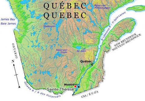
-
Article
Salaberry-de-Valleyfield
Salaberry-de-Valleyfield draws its labour force from the local population and its history is marked by often violent labour disputes (see COMPANY TOWNS). Originally (1874) it was called Salaberry, in honour of Charles d'Irumberry de SALABERRY.
"https://development.thecanadianencyclopedia.ca/images/tce_placeholder.jpg?v=e9dca980c9bdb3aa11e832e7ea94f5d9" // resources/views/front/categories/view.blade.php
https://development.thecanadianencyclopedia.ca/images/tce_placeholder.jpg?v=e9dca980c9bdb3aa11e832e7ea94f5d9
-
Article
Salmo
Salmo, BC, incorporated as a village in 1946, population 1139 (2011c), 1007 (2006c). The Village of Salmo is located in the Selkirk Mountains on the Salmo River at its junction with Erie Creek, 24 km north of the United States border.
"https://development.thecanadianencyclopedia.ca/images/tce_placeholder.jpg?v=e9dca980c9bdb3aa11e832e7ea94f5d9" // resources/views/front/categories/view.blade.php
https://development.thecanadianencyclopedia.ca/images/tce_placeholder.jpg?v=e9dca980c9bdb3aa11e832e7ea94f5d9