Browse "Cities & Populated Places"
-
Article
Stephenville
Stephenville, NL, incorporated as a town in 1952, population 6719 (2011c), 6588 (2006c). The Town of Stephenville is located on the north shore of St George's Bay in southwestern Newfoundland.
"https://development.thecanadianencyclopedia.ca/images/tce_placeholder.jpg?v=e9dca980c9bdb3aa11e832e7ea94f5d9" // resources/views/front/categories/view.blade.php
https://development.thecanadianencyclopedia.ca/images/tce_placeholder.jpg?v=e9dca980c9bdb3aa11e832e7ea94f5d9
-
Article
Stephenville Crossing
Stephenville Crossing, NL, incorporated as a town in 1958, population 1875 (2011c), 1960 (2006c). The Town of Stephenville Crossing is located at the head of St George's Bay on a low, flat floodplain between STEPHENVILLE and ST GEORGE'S on the west coast of Newfoundland.
"https://development.thecanadianencyclopedia.ca/images/tce_placeholder.jpg?v=e9dca980c9bdb3aa11e832e7ea94f5d9" // resources/views/front/categories/view.blade.php
https://development.thecanadianencyclopedia.ca/images/tce_placeholder.jpg?v=e9dca980c9bdb3aa11e832e7ea94f5d9
-
Article
Stettler
Stettler, Alta, incorporated as a town in 1906, population 5748 (2011c), 5445 (2006c). The Town of Stettler, the county seat for County of Stettler, is located on the rolling prairie of south-central Alberta 203 km southeast of Edmonton on a creek flowing north to the Battle River.
"https://development.thecanadianencyclopedia.ca/images/tce_placeholder.jpg?v=e9dca980c9bdb3aa11e832e7ea94f5d9" // resources/views/front/categories/view.blade.php
https://development.thecanadianencyclopedia.ca/images/tce_placeholder.jpg?v=e9dca980c9bdb3aa11e832e7ea94f5d9
-
Article
Stewart
Stewart, BC, incorporated as a district municipality in 1930, population 494 (2011c), 496 (2006c). The District of Stewart is located next to the Alaska Panhandle at the north end of the Portland Canal on the British Columbia coast.
"https://development.thecanadianencyclopedia.ca/images/tce_placeholder.jpg?v=e9dca980c9bdb3aa11e832e7ea94f5d9" // resources/views/front/categories/view.blade.php
https://development.thecanadianencyclopedia.ca/images/tce_placeholder.jpg?v=e9dca980c9bdb3aa11e832e7ea94f5d9
-
Article
Stikine Territory
Stikine Territory Between 1839 and the 1867 American purchase of Alaska, the HUDSON'S BAY COMPANY leased the continental portion of the Alaska Panhandle from the Russian American Fur Co.
"https://development.thecanadianencyclopedia.ca/images/tce_placeholder.jpg?v=e9dca980c9bdb3aa11e832e7ea94f5d9" // resources/views/front/categories/view.blade.php
https://development.thecanadianencyclopedia.ca/images/tce_placeholder.jpg?v=e9dca980c9bdb3aa11e832e7ea94f5d9
-
Article
Stonewall
Stonewall, Manitoba, incorporated as a town in 1908, population 4536 (2011c), 4376 (2006c). The Town of Stonewall is located 24 km northwest of Winnipeg on a limestone outcrop in the southern Interlake.
"https://development.thecanadianencyclopedia.ca/images/tce_placeholder.jpg?v=e9dca980c9bdb3aa11e832e7ea94f5d9" // resources/views/front/categories/view.blade.php
https://development.thecanadianencyclopedia.ca/images/tce_placeholder.jpg?v=e9dca980c9bdb3aa11e832e7ea94f5d9
-
Article
Stoney Creek
The first European settlers, primarily LOYALISTS, arrived from the US in 1786. The area was cleared for mixed farming and Stoney Creek attracted many saw and grain mills and other agricultural service activities.
"https://development.thecanadianencyclopedia.ca/images/tce_placeholder.jpg?v=e9dca980c9bdb3aa11e832e7ea94f5d9" // resources/views/front/categories/view.blade.php
https://development.thecanadianencyclopedia.ca/images/tce_placeholder.jpg?v=e9dca980c9bdb3aa11e832e7ea94f5d9
-
Article
Stony Plain
Stony Plain, Alta, incorporated as a town in 1908, population 15 051 (2011c), 12 363 (2006c). The Town of Stony Plain is located about 25 km west of EDMONTON. Settlement began in 1881 about 3 km south of the present town. This settlement was called Dogrump Creek but in 1892 was renamed Stony Plain.
"https://development.thecanadianencyclopedia.ca/images/tce_placeholder.jpg?v=e9dca980c9bdb3aa11e832e7ea94f5d9" // resources/views/front/categories/view.blade.php
https://development.thecanadianencyclopedia.ca/images/tce_placeholder.jpg?v=e9dca980c9bdb3aa11e832e7ea94f5d9
-
Article
Stratford
Urban growth was slow until the railway-building boom of the 1850s. Stratford businessmen lobbied for the forming in 1853 of the County of Perth, with Stratford as the county seat, and the county at once voted bonuses to railway companies.
"https://d2ttikhf7xbzbs.cloudfront.net/media/media/664057ff-dd11-4f37-abff-a514d6fb143e.jpg" // resources/views/front/categories/view.blade.php
https://d2ttikhf7xbzbs.cloudfront.net/media/media/664057ff-dd11-4f37-abff-a514d6fb143e.jpg
-
Article
Strathmore
Strathmore, Alta, incorporated as a town in 1911, population 12 305 (2011c), 10 280 (2006c). The Town of Strathmore is located 40 km east of CALGARY. Strathmore was named after Charles Bowes-Lyon, 13th earl of Strathmore (1824-1904), a forefather of Queen Elizabeth II.
"https://d2ttikhf7xbzbs.cloudfront.net/media/media/210a4861-11eb-4238-97ad-3bdd221a3b60.jpg" // resources/views/front/categories/view.blade.php
https://d2ttikhf7xbzbs.cloudfront.net/media/media/210a4861-11eb-4238-97ad-3bdd221a3b60.jpg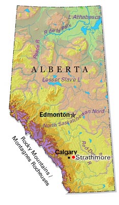
-
Article
Strathroy-Caradoc
During its early history Strathroy suffered a number of devastating fires. In 1868 a blaze wiped out a considerable portion of Strathroy's business section. Several fires in manufacturing plants in the late 1890s and an agricultural depression caused a period of economic downturn for the town.
"https://d2ttikhf7xbzbs.cloudfront.net/media/media/997b9858-a7a8-4f8a-8880-76bd7d7f9b96.jpg" // resources/views/front/categories/view.blade.php
https://d2ttikhf7xbzbs.cloudfront.net/media/media/997b9858-a7a8-4f8a-8880-76bd7d7f9b96.jpg
-
Article
Sturgeon Falls
Sturgeon Falls, Ontario, population centre, population 6,939 (2021 census), 6,916 (2016 census). Sturgeon Falls is located 5 km up the Sturgeon River from Lake Nipissing. It was incorporated as a town in 1895. After a failed court challenge aimed at maintaining a separate identity (1997), Sturgeon Falls is now the administrative centre for the provincially-mandated town of West Nipissing (incorporated 1990).
"https://development.thecanadianencyclopedia.ca/images/tce_placeholder.jpg?v=e9dca980c9bdb3aa11e832e7ea94f5d9" // resources/views/front/categories/view.blade.php
https://development.thecanadianencyclopedia.ca/images/tce_placeholder.jpg?v=e9dca980c9bdb3aa11e832e7ea94f5d9
-
Article
Summerland
Summerland, BC, incorporated as a district municipality in 1906, population 11 280 (2011c), 10 828 (2006c). The District of Summerland is located on the west bank of OKANAGAN LAKE in the southern interior of British Columbia between KELOWNA and PENTICTON.
"https://d2ttikhf7xbzbs.cloudfront.net/media/media/0244c898-89ec-490e-8fce-58f57b91df26.jpg" // resources/views/front/categories/view.blade.php
https://d2ttikhf7xbzbs.cloudfront.net/media/media/0244c898-89ec-490e-8fce-58f57b91df26.jpg
-
Article
Summerside
Beginning around 1910, the town experienced renewed prosperity as a fur-trading centre, stimulated by Sir Charles Dalton and Robert T. Oulton's successful breeding of silver foxes in captivity. In 1920 Summerside was established as the headquarters of the Canadian National Silver Fox Breeders' Assn.
"https://d2ttikhf7xbzbs.cloudfront.net/media/media/c92b22e5-2797-46d3-bd33-d318ecb6cc64.jpg" // resources/views/front/categories/view.blade.php
https://d2ttikhf7xbzbs.cloudfront.net/media/media/c92b22e5-2797-46d3-bd33-d318ecb6cc64.jpg
-
"https://d2ttikhf7xbzbs.cloudfront.net/media/media/a75c407d-aa04-450d-9516-94bdc0f4f3f3.jpg" // resources/views/front/categories/view.blade.php
https://d2ttikhf7xbzbs.cloudfront.net/media/media/a75c407d-aa04-450d-9516-94bdc0f4f3f3.jpg