Browse "Places"
-
Article
Pitt Meadows
Pitt Meadows, BC, incorporated as a city in 2007, population 17 736 (2011c), 15 623 (2006c). The City of Pitt Meadows is an agricultural community located in the lower Fraser Valley east of VANCOUVER on the north side of the FRASER RIVER at its junction with the Pitt River.
"https://development.thecanadianencyclopedia.ca/images/tce_placeholder.jpg?v=e9dca980c9bdb3aa11e832e7ea94f5d9" // resources/views/front/categories/view.blade.php
https://development.thecanadianencyclopedia.ca/images/tce_placeholder.jpg?v=e9dca980c9bdb3aa11e832e7ea94f5d9
-
Article
Music at Place des Arts
One of Canada's largest multidisciplinary arts complexes, Montreal's Place des Arts (PDA) grew from three halls in the 1960s to four in the 1970s and five in the 1990s. With the integration of the Musée d'art contemporain de Montréal (1992), the PDA become a major North American integrated centre for both the visual and performing arts. In 2011, a sixth hall the Mason symphonique, opened its doors. The complex also houses rehearsal halls, boutiques, underground parking, theatre storage facilities, restaurants, and office space.
"https://d2ttikhf7xbzbs.cloudfront.net/media/media/PlacedesArts_Credit_Caroline_Bergeron.jpg" // resources/views/front/categories/view.blade.php
https://d2ttikhf7xbzbs.cloudfront.net/media/media/PlacedesArts_Credit_Caroline_Bergeron.jpg
-
Article
Place Royale
By bringing a bust of the king to Québec in 1686, Champigny was acquiescing to the request Louis XIV made of his intendants the previous year to create "places royales" in his honour in the various provinces of his kingdom.
"https://d2ttikhf7xbzbs.cloudfront.net/media/media/4f37bed7-b7b9-44eb-abca-05fffb732fb5.jpg" // resources/views/front/categories/view.blade.php
https://d2ttikhf7xbzbs.cloudfront.net/media/media/4f37bed7-b7b9-44eb-abca-05fffb732fb5.jpg
-
Article
Placentia
Placentia, NL, incorporated as a town in 1945, population 3643 (2011c), 3898 (2006c). The Town of Placentia is located on PLACENTIA BAY on the west coast of the AVALON PENINSULA.
"https://development.thecanadianencyclopedia.ca/images/tce_placeholder.jpg?v=e9dca980c9bdb3aa11e832e7ea94f5d9" // resources/views/front/categories/view.blade.php
https://development.thecanadianencyclopedia.ca/images/tce_placeholder.jpg?v=e9dca980c9bdb3aa11e832e7ea94f5d9
-
Article
Placentia Bay
Placentia Bay, from the French plaisance (meaning a "pleasant place"), is a large, deep bay formed by Newfoundland's Burin Peninsula to the west, and the southwestern Avalon Peninsula to the east.
"https://d2ttikhf7xbzbs.cloudfront.net/media/media/1156688e-36f0-43f0-b71a-c95ed49e88d0.jpg" // resources/views/front/categories/view.blade.php
https://d2ttikhf7xbzbs.cloudfront.net/media/media/1156688e-36f0-43f0-b71a-c95ed49e88d0.jpg
-
Article
Plateau Hall/Auditorium le Plateau
Plateau Hall/Auditorium le Plateau. Montreal concert auditorium built in the early 1930s by the Catholic School Commission.of Montreal. Adjoining the school of the same name, it is situated on Calixa-Lavallée St, in the centre of Lafontaine Park.
"https://development.thecanadianencyclopedia.ca/images/tce_placeholder.jpg?v=e9dca980c9bdb3aa11e832e7ea94f5d9" // resources/views/front/categories/view.blade.php
https://development.thecanadianencyclopedia.ca/images/tce_placeholder.jpg?v=e9dca980c9bdb3aa11e832e7ea94f5d9
-
Article
Plessisville
Plessisville is named after Joseph-Octave Plessis, the eleventh bishop of Québec City. Plessisville was the first municipality developed in the Bois-Francs area. It had a rich, fertile soil ideal for agricultural development.
"https://d2ttikhf7xbzbs.cloudfront.net/media/media/396a361d-24d6-424a-b51f-b128a3b48bbd.jpg" // resources/views/front/categories/view.blade.php
https://d2ttikhf7xbzbs.cloudfront.net/media/media/396a361d-24d6-424a-b51f-b128a3b48bbd.jpg
-
Article
Point Amour Lighthouse
In 1858 the Point Amour Lighthouse was built to help sailors through the dangerous waters of the Strait of Belle Isle between Labrador and Newfoundland.
"https://development.thecanadianencyclopedia.ca/images/tce_placeholder.jpg?v=e9dca980c9bdb3aa11e832e7ea94f5d9" // resources/views/front/categories/view.blade.php
https://development.thecanadianencyclopedia.ca/images/tce_placeholder.jpg?v=e9dca980c9bdb3aa11e832e7ea94f5d9
-
Article
Point Pelee National Park
Point Pelee National Park (established 1918) is a protected area at the tip of Point Pelee, a long peninsula extending into the western end of Lake Erie, south of Leamington, Ontario. Middle Island — Canada’s southernmost piece of land located southwest of Point Pelee — was added to the park in 2000. At 15 km2, Point Pelee National Park is Canada’s second smallest national park. It’s also the southernmost tip of Canada’s mainland, located further south than northern California.
"https://d2ttikhf7xbzbs.cloudfront.net/media/new_article_images/25942993688_275b33c77b_o.jpg" // resources/views/front/categories/view.blade.php
https://d2ttikhf7xbzbs.cloudfront.net/media/new_article_images/25942993688_275b33c77b_o.jpg
-
Article
Pointe-au-Père
In 1663, the Jesuit priest Henri Nouvel landed on the south bank of the St Lawrence River and conducted the first mass. In 1696 this territory was the seigneurie de Lessard, granted to Pierre Lessard and Barbe Fortin, his wife.
"https://d2ttikhf7xbzbs.cloudfront.net/media/media/25f421c1-f50d-4f6f-9522-f72cc073a715.jpg" // resources/views/front/categories/view.blade.php
https://d2ttikhf7xbzbs.cloudfront.net/media/media/25f421c1-f50d-4f6f-9522-f72cc073a715.jpg
-
Article
Pointe-Claire
Pointe-Claire was first set up as a village municipality under the name of Saint-Joachim-de-la-Pointe-Claire in 1854. Its name was shortened when it was incorporated.
"https://development.thecanadianencyclopedia.ca/images/tce_placeholder.jpg?v=e9dca980c9bdb3aa11e832e7ea94f5d9" // resources/views/front/categories/view.blade.php
https://development.thecanadianencyclopedia.ca/images/tce_placeholder.jpg?v=e9dca980c9bdb3aa11e832e7ea94f5d9
-
Article
Pointe-du-Buisson Archaeological Sites
Pointe-du-Buisson is a small point of land (21 ha) extending into the waters of Lake St Louis (a widening of the St-Lawrence River) at the convergence of the Ottawa River.
"https://d2ttikhf7xbzbs.cloudfront.net/media/media/b8bf0f8e-3c7a-4b11-9fa4-efe4e14a1650.jpg" // resources/views/front/categories/view.blade.php
https://d2ttikhf7xbzbs.cloudfront.net/media/media/b8bf0f8e-3c7a-4b11-9fa4-efe4e14a1650.jpg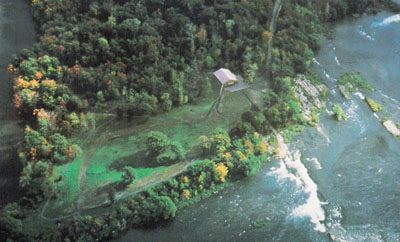
-
Article
Politics in British Columbia
The province of British Columbia has a majority New Democratic Party government, formed on 24 October 2020. The premier of the province is David Eby and the lieutenant-governor is Janet Austin. Its first premier, John Foster McCreight, was elected in 1871, after the province joined Confederation. Prior to Confederation, BC was a British colony, administered by a governor and a legislative assembly.
"https://d2ttikhf7xbzbs.cloudfront.net/media/new_article_images/PoliticsInBC/SirRichardMcBride_CityofVancouverArchives_LGN952.jpg" // resources/views/front/categories/view.blade.php
https://d2ttikhf7xbzbs.cloudfront.net/media/new_article_images/PoliticsInBC/SirRichardMcBride_CityofVancouverArchives_LGN952.jpg
-
Article
Politics in Newfoundland and Labrador
The province of Newfoundland and Labrador has a minority Liberal government, elected on 16 May 2019. The premier of the province is Andrew Furey and the Lieutenant Governor is Judy May Foote. Its first premier, Joey Smallwood, was elected in 1949, after the province joined Confederation. Prior to Confederation, Newfoundland was first a British colony, then beginning in 1907, a dominion of the British Empire. It has been governed in various ways throughout its history, beginning with naval law in the 1600s.
"https://d2ttikhf7xbzbs.cloudfront.net/media/media/f20cb6e1-b1bb-4a81-9c3b-acbd65f7feb8.jpg" // resources/views/front/categories/view.blade.php
https://d2ttikhf7xbzbs.cloudfront.net/media/media/f20cb6e1-b1bb-4a81-9c3b-acbd65f7feb8.jpg
-
Article
Ponoka
Ponoka, Alta, incorporated as a town in 1904, population 6773 (2011c), 6576 (2006c). The Town of Ponoka is located approximately 100 km south of Edmonton in rolling, rich parkbelt land. The Methodists established a mission to the Stoney at the nearby Samson Reserve in the late 1870s.
"https://development.thecanadianencyclopedia.ca/images/tce_placeholder.jpg?v=e9dca980c9bdb3aa11e832e7ea94f5d9" // resources/views/front/categories/view.blade.php
https://development.thecanadianencyclopedia.ca/images/tce_placeholder.jpg?v=e9dca980c9bdb3aa11e832e7ea94f5d9