Browse "Places"
-
Editorial
Editorial: The Arrival of Black Loyalists in Nova Scotia
The following article is an editorial written by The Canadian Encyclopedia staff. Editorials are not usually updated. “Freedom and a Farm.” The promise was exciting to the thousands of African Americans, most seeking to escape enslavement, who fought in British regiments during the American Revolutionary War (1775–83). Following the war, they joined tens of thousands of Loyalists — American refugees who had sided with the British. Between 80,000 and 100,000 Loyalists eventually fled the United States. About half came to British North America. The main waves arrived in 1783 and 1784. The territory that now includes the Maritime provinces became home to more than 30,000 Loyalists. Most of coastal Nova Scotia received Loyalist settlers, as did Cape Breton and Prince Edward Island (then called St. John’s Island).
"https://d2ttikhf7xbzbs.cloudfront.net/media/media/be13527b-b76d-408a-afca-30acbd4f7bfc.png" // resources/views/front/categories/view.blade.php
https://d2ttikhf7xbzbs.cloudfront.net/media/media/be13527b-b76d-408a-afca-30acbd4f7bfc.png
-
Article
Blainville
In 1673, in order to develop the young colony of New France, Governor Louis de Buade de Frontenac gave large concessions of land to administrators, priests and high-ranking soldiers who became seigneurs. The seigneurie des Mille-Îles was created north of the river that bears the same name.
"https://d2ttikhf7xbzbs.cloudfront.net/media/media/f10e3371-4bbb-40a2-b591-f640fdca2af3.jpg" // resources/views/front/categories/view.blade.php
https://d2ttikhf7xbzbs.cloudfront.net/media/media/f10e3371-4bbb-40a2-b591-f640fdca2af3.jpg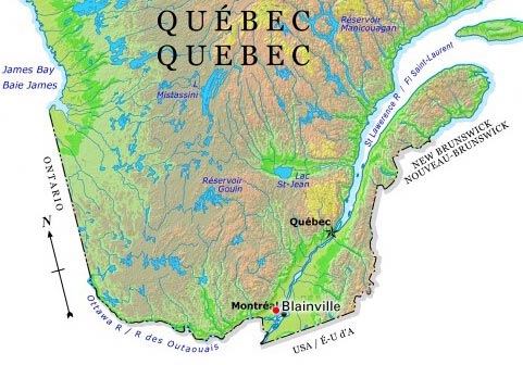
-
Article
Blanc-Sablon Archaeological Sites
The Blanc-Sablon area is located on Québec's eastern edge, close to the border with Labrador.
"https://d2ttikhf7xbzbs.cloudfront.net/media/media/43ea7f0d-1cb8-4765-8fe8-6a9bd647b147.jpg" // resources/views/front/categories/view.blade.php
https://d2ttikhf7xbzbs.cloudfront.net/media/media/43ea7f0d-1cb8-4765-8fe8-6a9bd647b147.jpg
-
Article
Blind River
Blind River, Ont, incorporated as a town in 1906, population 3549 (2011c), 3780 (2006c). The Town of Blind River is located at the mouth of the Mississagi River on the North Channel of Lake Huron, 132 km southeast of Sault Ste Marie.
"https://development.thecanadianencyclopedia.ca/images/tce_placeholder.jpg?v=e9dca980c9bdb3aa11e832e7ea94f5d9" // resources/views/front/categories/view.blade.php
https://development.thecanadianencyclopedia.ca/images/tce_placeholder.jpg?v=e9dca980c9bdb3aa11e832e7ea94f5d9
-
Article
Bloodvein River
Named, perhaps, for the red granite stripes running through the bedrock near its source, the Bloodvein River begins in the vast wilderness of the Canadian Shield, 600 km northwest of Thunder Bay, Ont, and 500 km northeast of Winnipeg.
"https://development.thecanadianencyclopedia.ca/images/tce_placeholder.jpg?v=e9dca980c9bdb3aa11e832e7ea94f5d9" // resources/views/front/categories/view.blade.php
https://development.thecanadianencyclopedia.ca/images/tce_placeholder.jpg?v=e9dca980c9bdb3aa11e832e7ea94f5d9
-
Article
Bloody Falls
Bloody Falls are rapids located about 15 km above the mouth of the Coppermine River in the central Arctic.
"https://d2ttikhf7xbzbs.cloudfront.net/media/media/ae69d3f2-aebe-4a53-b1a8-ddfebac57e3f.jpg" // resources/views/front/categories/view.blade.php
https://d2ttikhf7xbzbs.cloudfront.net/media/media/ae69d3f2-aebe-4a53-b1a8-ddfebac57e3f.jpg
-
Article
Blue Mountains
The Blue Mountains (Montagnes Bleues) is a 240 km long group of high hills along the Canada and United States border in the Eastern Townships.
"https://development.thecanadianencyclopedia.ca/images/tce_placeholder.jpg?v=e9dca980c9bdb3aa11e832e7ea94f5d9" // resources/views/front/categories/view.blade.php
https://development.thecanadianencyclopedia.ca/images/tce_placeholder.jpg?v=e9dca980c9bdb3aa11e832e7ea94f5d9
-
Article
Bluefish Caves
Bluefish Caves contain the oldest undisturbed archaeological evidence in Canada.
"https://d2ttikhf7xbzbs.cloudfront.net/media/media/b91c5592-6724-4e23-8a45-aa3a4ce223f0.jpg" // resources/views/front/categories/view.blade.php
https://d2ttikhf7xbzbs.cloudfront.net/media/media/b91c5592-6724-4e23-8a45-aa3a4ce223f0.jpg
-
Article
Bocabec Archaeological Site
The 1883 excavation of a portion of the Bocabec site by the Natural History Society of New Brunswick marked the beginning of systematic, scientific examinations of shell-bearing archaeological sites (see shell middens) in Canada.
"https://d2ttikhf7xbzbs.cloudfront.net/media/media/29f3aa50-f086-4d99-9f28-dbc389692cf9.jpg" // resources/views/front/categories/view.blade.php
https://d2ttikhf7xbzbs.cloudfront.net/media/media/29f3aa50-f086-4d99-9f28-dbc389692cf9.jpg
-
Article
Bois-des-Filion
Bois-des-Filion owes its name to Antoine Feuillon dit Filion, the French pioneer who settled there in 1684, and to the large maple grove located on the Filion family property.
"https://d2ttikhf7xbzbs.cloudfront.net/media/media/c3935abd-db71-4e62-bb4b-b6fa5fc7d2ed.jpg" // resources/views/front/categories/view.blade.php
https://d2ttikhf7xbzbs.cloudfront.net/media/media/c3935abd-db71-4e62-bb4b-b6fa5fc7d2ed.jpg
-
Article
Boisbriand
First set up as a municipality under the name of Sainte-Thérèse-Ouest in 1946, its name was changed in 1974. The name recalls Michel-Sidrac Dugué, Sieur de Boisbriand (1638-88), to whom was granted the seigneury des Mille-Îles in 1683.
"https://development.thecanadianencyclopedia.ca/images/tce_placeholder.jpg?v=e9dca980c9bdb3aa11e832e7ea94f5d9" // resources/views/front/categories/view.blade.php
https://development.thecanadianencyclopedia.ca/images/tce_placeholder.jpg?v=e9dca980c9bdb3aa11e832e7ea94f5d9
-
Article
Boissevain
The first homesteaders took up land in the area in the late 1870s and early 1880s, and in 1885 the CPR reached the townsite. By the early 1890s Boissevain was a thriving community with hotels, stores, farm implement dealers and a lumber yard.
"https://d2ttikhf7xbzbs.cloudfront.net/media/media/a2793534-9aca-4f3f-a8a3-00f3d75ac298.jpg" // resources/views/front/categories/view.blade.php
https://d2ttikhf7xbzbs.cloudfront.net/media/media/a2793534-9aca-4f3f-a8a3-00f3d75ac298.jpg
-
Article
Boîtes à chansons
Boîtes à chansons. Name given to the intimate rooms which sprang up in the mid-1950s outside the normal entertainment circuits and in which most young Quebec chansonniers made their start.
"https://development.thecanadianencyclopedia.ca/images/tce_placeholder.jpg?v=e9dca980c9bdb3aa11e832e7ea94f5d9" // resources/views/front/categories/view.blade.php
https://development.thecanadianencyclopedia.ca/images/tce_placeholder.jpg?v=e9dca980c9bdb3aa11e832e7ea94f5d9
-
Article
Bonar Law Historic Site
Bonar Law is a provincial historic site near Rexton, NB. The Right Honourable Andrew Bonar Law served briefly as Prime Minister of Great Britain in 1922-23.
"https://development.thecanadianencyclopedia.ca/images/tce_placeholder.jpg?v=e9dca980c9bdb3aa11e832e7ea94f5d9" // resources/views/front/categories/view.blade.php
https://development.thecanadianencyclopedia.ca/images/tce_placeholder.jpg?v=e9dca980c9bdb3aa11e832e7ea94f5d9
-
Article
Bonavista
Bonavista, NL, incorporated as a town in 1964, population 3589 (2011c), 3764 (2006c). The Town of Bonavista is located near Cape Bonavista on Newfoundland's northeast coast.
"https://development.thecanadianencyclopedia.ca/images/tce_placeholder.jpg?v=e9dca980c9bdb3aa11e832e7ea94f5d9" // resources/views/front/categories/view.blade.php
https://development.thecanadianencyclopedia.ca/images/tce_placeholder.jpg?v=e9dca980c9bdb3aa11e832e7ea94f5d9