Labrador
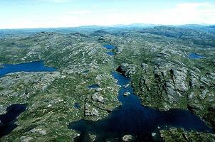
Labrador, mainland section of the province of Newfoundland, lies almost entirely north of the Island, 20 km across the Strait of Belle Isle, and some 800 km south of Greenland. The long (1125 km) Labrador coast is indented by innumerable fjords, bays and inlets, notably Hamilton Inlet (Lake Melville), which penetrates the rocky interior for over 250 km. Geologically, Labrador is part of the Canadian Shield, a massive granite plateau rising some 300 m from sea level to the interior watershed. Most of coastal and northern Labrador is bare rock and barren tundra, but river valleys south from Lake Melville and the deep interior contain valuable forest reserves.
The Torngat Mts of the far north rise in splendid isolation - the highest peaks east of the Rockies. Though in the same latitude as the British Isles, Labrador's forbidding terrain and extreme climate support only sparse settlement. The Labrador Current, sweeping south from arctic waters, chills the coast and clogs harbours with ice from Dec to May. The primary settlements are Forteau, Port Hope, Simpson, Cartwright, Rigolet, Makkovik, Postville, Hopedale and Nain south to north along the coast; North West River and Happy Valley-Goose Bay on Lake Melville; and Churchill Falls, Wabush and Labrador City in the interior.
History
The Labrador coast has been occupied for a very long time. Evidence of Maritime Archaic Native occupation, dating back at least 7000 years, has been found at L'Anse Amour Burial Site in the south. Labrador was likely the "Markland" of the Viking sagas, which described the anomalous silvery beaches near Groswater Bay. Basque fishermen established a great whale fishery, centered at Red Bay on the northeast coast of the Strait of Belle Isle, even before Jacques Cartier explored the coast in the early 16th century.
Maritime Archaic culture was displaced about 4000 years ago by southward expansion of Paleoeskimos from the Arctic, who were in turn displaced by the ancestors of the Montagnais-Naskapi and Inuit, Portuguese explorers were active along the coast and the name "Labrador," which was first applied to the coast of Greenland, likely derives from the Portuguese explorer João Fernandes, a lavrador or "landholder" in the Azores. Early European occupation was entirely focused on the coastal fishery and was fiercely opposed by the Inuit to the north and the Naskapi in the south. Control of the coast was contested by the British and French, but control by either was tenuous. In the early 19th century, thousands of New England fishermen and whalers descended on the coast annually.
The Labrador Boundary Dispute was one of the most celebrated legal cases in British colonial history. Though Newfoundland's claim to the watershed of all rivers flowing into the Atlantic Ocean is recognized in the Constitution Act, many Quebecers still consider Labrador part of "Nouveau-Québec."
Economy
Settlement was haphazard, begun by a few fishermen who stayed on each winter (called Liveyers), while thousands of "stationers" (those who fished from land bases in summer) and "floaters" (those who used schooners as their bases) came and went with the fishing season. George Cartwright established a business at Cape Charles in 1770 and persevered for 16 years. The Moravians set up a mission at Nain in 1771 that has been in continuous operation since. The Hudson's Bay Company established its first post at Rigolet in 1834, another at North West River in 1836 and a third at Cartwright. HBC employee John McLean explored the interior in 1839, but the fur trade remained marginal in Labrador.
In the 1890s geologist A.P. Low reported the massive iron-ore deposits of the interior and in 1937 and 1939 Finnish geographer V.A. Tanner compiled the most detailed designation of Labrador to date. The small coastal settlements of Labrador were among the most isolated, deprived and neglected in the world. With the exception of the Moravian mission at Nain, Labrador was without medical care, schools or adequate housing until the heroic efforts of Wilfred Grenfell in the 1890s. Grenfell and his associates established hospitals, schools, orphanages and co-ops - financed by fund-raising tours around the world.
The break with the traditional dependence on the fishery alone came during WWII when the airport at Goose Bay was built as a staging point for Ferry Command. It later continued as a USAF base and by the early 1950s was the second-busiest airport in the world. Happy Valley grew up nearby. Meanwhile the completion of the monumental Quebec North Shore and Labrador Ry (1954) opened the vast iron reserves of the interior, and BRINCO tapped the huge power of the Churchill River at Churchill Falls - the second-largest hydroelectric development in Canada.
In the early 1990s, 2 diamond prospectors found large concentrations of nickel, along with copper and cobalt, at Voisey Bay, near Nain. This led to a staking frenzy in the area from 5000-8000 claims in previous years to an estimated 200 000 claims in 1995.

 Share on Facebook
 Share on X
 Share by Email
 Share on Google Classroom


