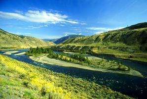
Thompson River, 489 km long, rises in the Cariboo district of the Rocky Mountains and flows south as the North Thompson River. It is joined at Kamloops by the South Thompson R from Shuswap Lk, and the 2 flow united, carrying their blue-green waters into the Fraser River at Lytton. The banks of the lower course are hilly and almost barren, except for sagebrush, and many of the spectacular terraces are used for cattle grazing and fodder crops. Both the CPR and CNR transcontinental lines follow the river from Kamloops to Lytton. Simon Fraser mistakenly believed that David Thompson had found the river, and named it for him.
-
- MLA 8TH EDITION
- . "Thompson River". The Canadian Encyclopedia, 04 March 2015, Historica Canada. development.thecanadianencyclopedia.ca/en/article/thompson-river. Accessed 22 November 2024.
- Copy
-
- APA 6TH EDITION
- (2015). Thompson River. In The Canadian Encyclopedia. Retrieved from https://development.thecanadianencyclopedia.ca/en/article/thompson-river
- Copy
-
- CHICAGO 17TH EDITION
- . "Thompson River." The Canadian Encyclopedia. Historica Canada. Article published February 07, 2006; Last Edited March 04, 2015.
- Copy
-
- TURABIAN 8TH EDITION
- The Canadian Encyclopedia, s.v. "Thompson River," by , Accessed November 22, 2024, https://development.thecanadianencyclopedia.ca/en/article/thompson-river
- Copy
Thank you for your submission
Our team will be reviewing your submission
and get back to you with any further questions.
Thanks for contributing to The Canadian Encyclopedia.
CloseArticle
Thompson River
Published Online February 7, 2006
Last Edited March 4, 2015
Thompson River, 489 km long, rises in the Cariboo district of the Rocky Mountains and flows south as the North Thompson River.