Share on Facebook
 Share on X
 Share by Email
 Share on Google Classroom


Cloud
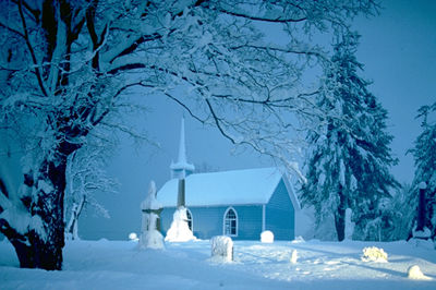
Cloud, visible suspension in the atmosphere composed of tiny water droplets or ICE crystals from about one to a few hundred micrometres in diameter. Clouds occur when moist air cools to its saturation point as a result of loss of heat through vertical ascent and expansion, by emission of infrared radiation or by mixing with cooler air. In Canada, the monthly mean cloud cover (the fraction of the sky covered by clouds) varies from about 0.5 on the Prairies to 0.8 or more on the West and East Coasts in winter.
Luke Howard, a British pharmacist, proposed the first cloud classification system in 1803 using Latin descriptive terms. The system continues in use today, having been adopted and adapted by the World Meteorological Organization. Clouds are named according to the nature of their vertical motion, their composition and their altitude or temperature. Two basic varieties are distinguished according to air motion. Heap clouds (cumulus family) result from local convection (rapid overturning) in an unstable atmosphere; layer clouds (stratus family) result from slow, widespread, vertical lifting or overturning. Nimbus signifies a precipitating cloud; cirrus, a high-level, ice-crystal cloud. A cloud that forms at the surface is called FOG; middle-level clouds (2-7 km above ground) are termed altus. Alone, in combination or with other adjectives, the terms stratus, cumulus, cirrus, nimbus and altus are used to describe the more than 100 cloud types that have been named.
Formation and Behaviour
Cloud droplets form on hygroscopic (moisture-retaining) particles, about 0.1-1.0 µm in diameter, called cloud condensation nuclei. Cloud droplet concentrations may reach 1000/cm3 and a liquid-water concentration of 0.1-10 g/m3 of air is typical. Cloud droplets fall through the air at a speed of only a few millimetres per second, being easily held aloft by vertical air currents of several centimetres to several metres per second. Thus clouds appear to float in the sky.Cloud droplets grow predominantly by condensation of water vapour when they are small and by collision and coalescence with each other when larger. In clouds with no ice (generally those warmer than -10°C to -15°C), RAIN occurs only if collision and coalescence produce millimetre-size raindrops before the cloud evaporates as a result of warming or mixing with its environment (the warm rain process). Each raindrop results from the coalescence of a million or more cloud droplets. Raindrops fall at a speed between about 4 m/s (for a 1mm diameter raindrop) to 9 m/s (for a 5mm diameter raindrop). Contrary to popular belief, large falling raindrops are not teardrop-shaped, but hamburger shaped, being flattened by aerodynamic pressure. Liquid cloud droplets do not freeze at 0°C like the water in ponds and lakes. Rather, because they are pure and tiny, they normally supercool to temperatures well below 0°C before freezing.
In clouds extending to altitudes where the temperature decreases below about -15°C, tiny ice nuclei initiate the freezing of some, but not all, of the supercooled droplets. Thus many clouds in midlatitudes consist of co-existing supercooled water droplets and ice crystals. In such clouds, the ice crystals grow rapidly by vapour deposition, while the nearby unfrozen droplets evaporate. The ice crystals may then aggregate into snowflakes or grow into snow pellets by sweeping out supercooled cloud droplets as they fall. Depending upon season and cloud vigour, snowflakes and snow pellets may reach the ground intact, may melt and fall as rain or may continue to grow into hailstones (see HAIL). This cold rain process is thought to be predominant in Canada.
Weather modification is an attempt to initiate the cold rain process in clouds deficient in ice crystals by seeding them with dry ice pellets or with silver iodide particles, which act as ice nuclei (see RAINMAKING). In warm clouds, seeding with hygroscopic particles (sea salt, for example) is used instead to try to enhance rainfall.
Viewed from a satellite, clouds of all types are seen to be organized into bands, clusters and swirling patterns, reflecting large-scale motions of the atmosphere. SATELLITE images of cloud organization are very helpful in WEATHER FORECASTING.
Basic Cloud Types
Role of Clouds
In addition to producing precipitation and thereby participating in the Earth's hydrological cycle, clouds play other important roles. By reflecting solar radiation, they keep the temperature of the atmosphere cooler than it would be without clouds. Because they absorb infrared radiation strongly and re-emit some of it back towards the surface, clouds are also important contributors to the atmospheric greenhouse effect, which warms the surface of the Earth (see GLOBAL WARMING). It is now thought that these 2 thermal effects of clouds counteract each other on a global scale in such a way as to produce a small overall cooling effect on the climate system. Cumulus cloud formation is important in the vertical mixing of heat, moisture and momentum from the surface into the atmosphere. Because of this vertical mixing, the temperature in the lower atmosphere generally decreases with height at a rate of between 6 and 10°C/km. Clouds are important crucibles for atmospheric chemistry, and cloud formation and precipitation help to cleanse the atmosphere of POLLUTION.
Scientists have developed software called numerical cloud models, which are used to simulate and visualize the growth and development of clouds and many of their features. These models are run on supercomputers. They can be tested with measurements made by instrumented aircraft which fly through clouds carrying instruments designed to count and size condensation and ice nuclei, cloud droplets and ice crystals, and raindrops, snowflakes and hailstones. Clouds and their precipitation are also studied remotely using satellite REMOTE SENSING and weather RADAR.
Cumulus Clouds
Cumulus clouds typically arise in the afternoon of sunny spring or summer days. They are generally tall with flat bases and rounded tops, sometimes described as resembling cauliflower or popcorn. After the sun has warmed the ground and begun to evaporate water from the surface (this heating and evaporation can be particularly strong over recently plowed fields), the air near the ground will become warm and moist, and hence lighter than its surroundings, and begin to rise. These invisible rising air parcels are the thermals that soaring birds and glider pilots use to ascend in the atmosphere (see BIRD FLIGHT and SOARING).
As the thermals rise, they expand and cool until they reach the saturation level. At this point, the water vapor, which is invisible, condenses spontaneously to form visible cloud droplets. This is the base of the cumulus cloud. The release of latent heat during condensation provides more energy for upward motion to the cloudy air and causes it to accelerate, producing an updraft of several metres per second. Eventually the rising cumulus enters a warmer layer of air, where it is heavier than its environment. The updraft then begins to slow down, finally stopping completely several kilometres above the cloud base. This entire process takes about half an hour, and the cumulus cloud will by now have produced a rain shower or a snow flurry. Later it may vanish without a trace, as the cloudy air mixes with its dry environment and the cloud droplets evaporate.
Cumulonimbus
Under conditions of very great atmospheric instability (occasioned by particularly warm and humid air trapped near the ground with cold, dry air aloft), a cumulus cloud can become extremely vigorous, with updrafts of several tens of metres per second penetrating upwards 10 km or more into the atmosphere, and being brought to a halt in its ascent only by the very stable air of the stratosphere. Such cumulus clouds are referred to as cumulonimbus and are usually accompanied by heavy rainfall, LIGHTNING and hail. Often they occur in clusters or lines spanning horizontal distances of 100 km or more.
Cumulonimbus clouds are readily recognized from a distance because of their anvil-like appearance. The anvil top is an extensive cloud of ice crystals that constitutes the "exhaust" of the cumulonimbus, forced to spread out horizontally by the stable stratosphere, and then carried downsteam by the very strong upper level winds. When a cumulonimbus cloud or cluster rotates, it may give rise to a TORNADO. In addition to rotation, telltale signs of possible, imminent tornado formation are a smooth shelf cloud or a ragged wall cloud that develops below the usually flat base of the cumulonimbus. Just before the tornado touches the ground, a descending cone-like funnel cloud may also be seen.
Altocumulus
Despite their name, altocumulus clouds are quite unlike ordinary cumulus clouds. They are puffy in appearance like young cumulus and are generally composed of water droplets rather than ice crystals, but they rarely exhibit much vertical development and hence seldom produce precipitation. If they do, it usually evaporates before reaching the ground. They are not formed by air that has risen from the surface. Instead they form in moist, unstable layers of air aloft, which may be the evaporated remnants of a cumulonimbus cloud. By convention, they are considered to occur from 2 to 7 km above ground.
Altocumulus form in a thin layer perhaps a kilometre or so thick. This cloudy layer becomes unstable as its base is heated by the absorption of infrared energy emitted by the warm ground. At the same time its top is cooled by the emission of infrared radiation to space and by evaporation. This leads to overturning in the layer and gives rise to a mottled pattern of cloudlets. If there is a wind shear through the layer (ie, a stronger wind at the top than at the bottom), these cloudlets become organized into herringboned cloudy rolls with clear air between them. Because altocumulus layers are thin, they do not reduce sunlight very much. However some of the infrared energy they absorb from the ground is re-emitted downwards, keeping the surface from cooling rapidly overnight.
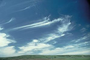
Cirrus
The highest and coldest widely occurring clouds are cirrus, and these consist entirely of ice crystals. Seen from afar, ice crystals in cirrus clouds give them a fibrous, feathery or hairlike appearance (cirrus means a curl of hair). The ice crystals in them are tiny; they fall slowly (a few tens of centimetres per second) and they do not evaporate quickly. Consequently, cirrus clouds change slowly and can persist for many hours. Cirrus clouds often occur in the vicinity of the subtropical jet stream, a river of fast-moving air at an altitude of about 10 km with speeds up to 250 km/h. When the precipitating cirrus ice crystals fall into more slowly moving air below the jet stream, they trail behind their parent cloud in long streaks called mare's tails. Cirrus clouds are perhaps the most beautiful of all clouds, because the ice crystals in them often give rise to colorful haloes, sun dogs, arcs and other optical effects, caused by refraction of light in ice crystal prisms. A veil of cirrus clouds (cirrostratus) may be the precursor of deteriorating weather, since it often occurs ahead of lower, precipitating clouds.
Albedo
Because clouds are composed of such large numbers of tiny water particles, they are very good scatterers of sunlight and are said to have a high albedo. The droplets in a small cumulus cloud have a total surface area of about 1000 km2. Thus even a small cloud reflects 90% or more of the incident sunlight, making it appear brilliantly white when seen from above or from the side. Viewed from below, however, clouds appear dark, because most of the sunlight that enters them has already been scattered back to space or absorbed by the cloud droplets.