Share on Facebook
 Share on X
 Share by Email
 Share on Google Classroom
The Western Interior Seaway refers to the ancient inland sea that covered the interior of North America during the Cretaceous. At its greatest extent, the seaway covered a length of about 5,000 km, connecting the present-day Arctic Ocean with the Gulf of Mexico, and divided the North American continent into two land masses, Laramidia and Appalachia. The marine life that inhabited the Western Interior Seaway included plants such as algae, microscopic life such as radiolarians, invertebrates such as ammonites, belemnites, squid, crabs, snails, clams and shrimp, and vertebrates such as fish, sharks, rays, skates, seabirds, turtles, crocodiles and the extinct marine reptiles, mosasaurs and plesiosaurs. Today, many of the natural resources mined in the western interior of North America, such as coal, petroleum products and bentonite clay, are a result of particular environments created by the Western Interior Seaway.
How Was the Western Interior Seaway Formed?
Formation of the Western Interior Seaway began over 150 million years ago, during the Jurassic, when the Sevier orogeny mountain building event led to the development of a foreland basin in the western interior of North America. Two main tectonic processes are largely responsible for the enormous size of the western interior basin: 1) flexural subsidence, or a dip in the Earth’s crust due to orogenic loading (mountain-building) along the west coast of the continent, and 2) dynamic subsidence, or a dip in the Earth’s crust caused by the subduction of the Farallon oceanic plate beneath the westward moving North American continental plate, creating a downward pull in mantle convection beneath the western interior basin.
The spatial evolution of the North American orogenic system occurred over four distinct stages.
First, oceanic plate subduction occurred, increasing magma activity and foreland basin development during the Late Jurassic.
Second, flexural loading and dynamic subsidence processes resulted in the expansion of the Western Interior Seaway during the Early and Late Cretaceous.
Third, the angle of the subducting oceanic plate became shallower during the Late Cretaceous and led to increased volcanic activity between 80 and 90 million years ago.
Fourth, several uplift events caused by the Laramide orogeny during the Late Cretaceous and Paleogene, between 80 and 40 million years ago, resulted in the disruption of the foreland basin and, ultimately, the disappearance of the Western Interior Seaway.
Did you know?
The Western Interior Seaway has no direct modern analogue on present-day Earth. Although several large inland seas exist today, such as Hudson Bay and the Baltic Sea, none are comparable in size to the ancient Western Interior Seaway. In addition to its size, another unique quality of the Western Interior Seaway is that it connected two water masses in very different climate zones: polar waters from the present-day Arctic Ocean and subtropical waters from the modern Gulf of Mexico.

How Did the Western Interior Seaway Disappear?
Significant uplift events of the North American Cordillera caused by the Laramide orogeny between 80 and 40 million years ago led to the recession and disappearance of the Western Interior Seaway near the end of the Cretaceous. After more than 30 million years of connecting oceanic waters continuously to the north and intermittently to the south beginning around 105 million years ago, the Western Interior Seaway lost its ocean connections around 70 million years ago. The Cannonball Sea, a Cenozoic Era remnant of the Western Interior Seaway representing the last marine incursion into the western interior of North America, likely had a connection with the Atlantic Ocean sometime between 56 and 66 million years ago.

Physical Features
The Western Interior Seaway’s estimated maximum length is around 5,000 km, and its estimated maximum width is 1,500–2,000 km. The maximum depth of the seaway may have been over 600 m, though the average water depth throughout most of the seaway is estimated to be around 200 m.
The Earth’s surface experienced some of the warmest sustained temperatures during the Late Cretaceous, when the Western Interior Seaway existed. The warmest interval experienced during mid-Cretaceous time is referred to as the mid-Cretaceous Thermal Maximum (KTM) or the Cenomanian-Turonian Thermal Maximum. Recent research indicates that maximum global sea-surface temperatures of more than 30°C at low and lower mid-latitudes were experienced during the Cenomanian-Turonian interval (97–90 million years ago). Average bottom seawater temperature for the central portion of the Western Interior Seaway, which would be in present-day Saskatchewan and Manitoba, was approximately 25°C during most of the Late Cretaceous. During the KTM, very warm bottom-water temperatures of 28–34°C have been reported for the southwest margin of the Western Interior Seaway.
Ecosystems
The Western Interior Seaway hosted a variety of marine life, including both familiar organisms that have close relatives still living today and less familiar organisms that became extinct during the end-Cretaceous extinction event.

Photosynthetic organisms included microscopic plant life in the forms of algae, including organic-shelled dinoflagellates, calcium carbonate-shelled coccolithophores, foraminifera with shells of multiple chemical compositions, silica-shelled diatoms, and radiolarians that had symbiotic relationships with alga. The chalky-shelled coccolithophores were largely responsible for the numerous and thick chalk and calcareous mudstone deposits around the globe for which the Cretaceous was named (from Latin cretaceus “chalk-like”).

Invertebrate life of the Western Interior Seaway included many groups with modern relatives, including crustacean, molluscs and annelids.
Vertebrate life of the Western Interior Seaway included many familiar marine groups still living today, such as fish, sharks and turtles, as well as less familiar groups that are now extinct, such as the mosasaurs and plesiosaurs. Fish were the most numerous and diverse of the vertebrate groups to inhabit the seaway, consisting of many ray-finned fish and cartilaginous fish, more commonly known as sharks, rays and skates. The largest vertebrates to inhabit the seaway consisted of the large bony fish Xiphactinus audax, with a maximum body length of more than 5 m, the mosasaurs Mosasaurus hoffmani and Tylosaurus pembenensis, with maximum body length estimates of 17 m and 12–15 m respectively, and the elasmosaurid plesiosaur Albertonectes vanderveldei, with a body length of more than 11 m.
Did you know?
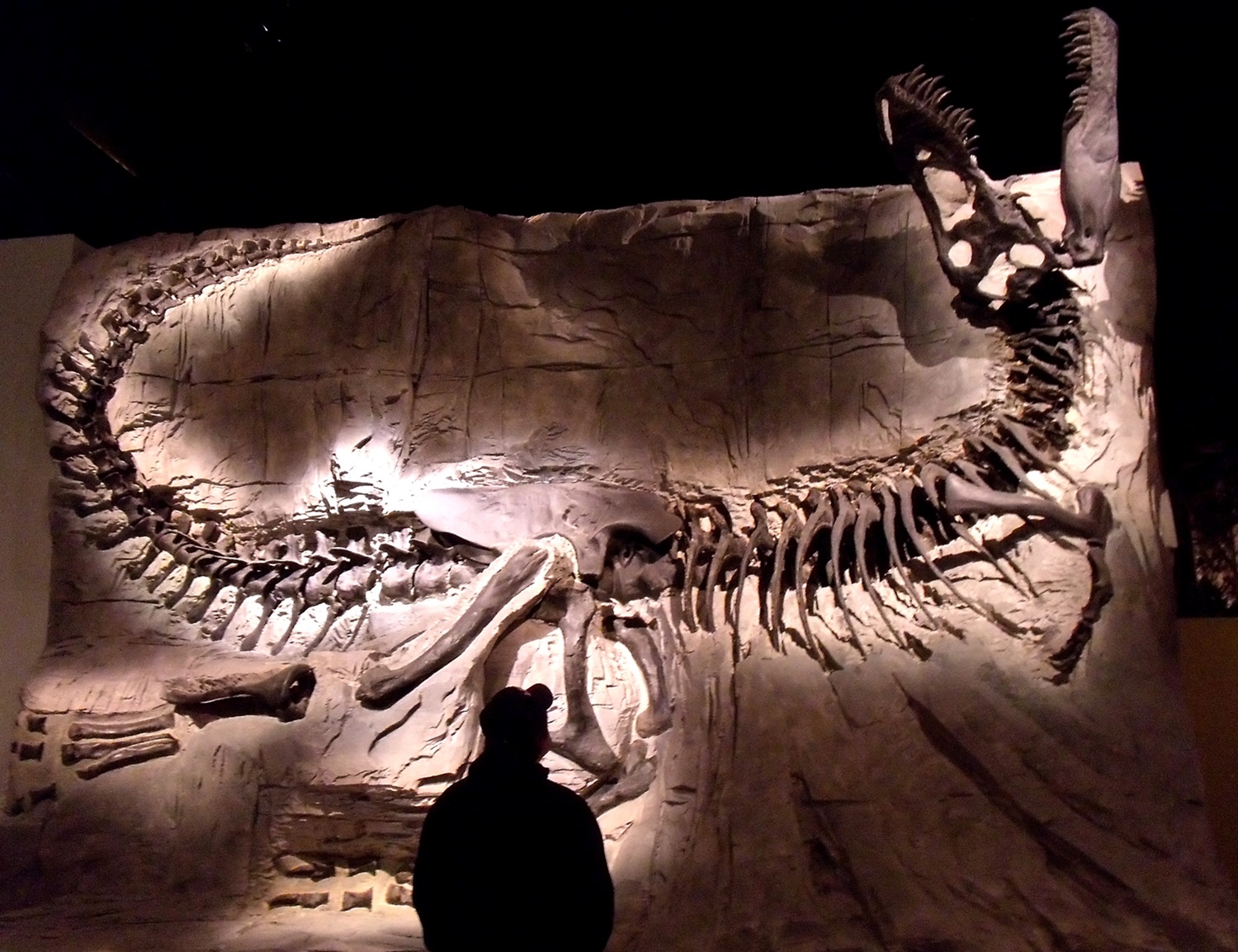
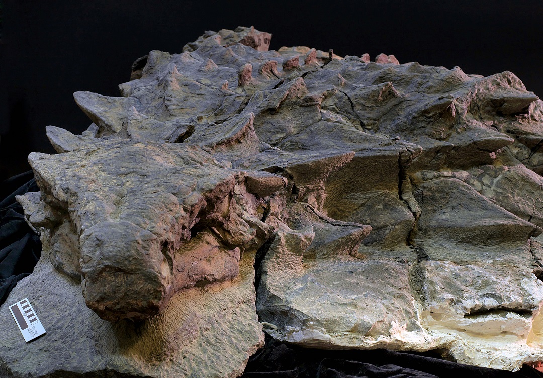
The marine deposits of the Western Interior Seaway also contain fossils of terrestrial life representing land-dwelling animal and plant remains that were transported from land to sea after death. The most common terrestrial fossil in Western Interior Seaway deposits is petrified wood, including wood from bald cypress trees, though nearly complete fossilized dinosaur skeletons have been found in certain areas, such as southern and central Alberta. Perhaps the most famous and best-preserved dinosaur fossil ever discovered in Canada, the Suncor mine nodosaur Borealopelta markmitchelli on display in Drumheller, Alberta, was buried and preserved on the Western Interior Seaway seafloor approximately 110 million years ago. Fossil occurrences of dinosaurs and other terrestrial life in marine deposits can have extreme scientific value since they offer a rare glimpse into neighbouring terrestrial ecosystems during periods of elevated sea levels and when preservation of terrestrial deposits and remains of terrestrial life were less common.

Impact on Modern Geology and Geography
Cretaceous bedrock formed from Western Interior Seaway seabed deposits hosts natural resources of many forms. The most notable natural resources include coal, natural gas, crude oil, bitumen and bentonite. The distribution of these natural resources can mainly be attributed to the tectonic processes of the Sevier and Laramide orogenies, sea level changes and regional climate.
Coastal plains adjacent to the seaway were ideal environments for hosting peatlands, which, following their burial and compaction, led to the formation of coal deposits. In Canada, some of the largest Cretaceous coal deposits are in present-day British Columbia, Alberta and southern Saskatchewan, where extensive coastal plains existed along the west coast of the Western Interior Seaway during the Cretaceous.
The Cretaceous bedrock of the western interior of North America is made up of several thick, marine organic-carbon-rich, carbonate rock units which have acted as petroleum sources and hosts for some modern crude oil, bitumen and natural gas accumulations. In the United States, these rock units (in order from oldest to youngest) include the Graneros Shale, Greenhorn, Carlile and Niobrara formations of Utah, Colorado and Kansas. In Canada, they include the coeval (time-equivalent) Belle Fourche, Second White Specks, Carlile, Niobrara and Milk River formations of southeastern Alberta and Saskatchewan and the Ashville, Favel and Carlile formations of southwestern Manitoba.
Bentonite, volcanic ash that has been chemically altered to clay by seawater, is a commercially valuable resource used as a purifying agent for oils and wine, for drilling mud for wells and for pelletizing iron ore, among many other applications. Bentonite has been mined, and continues to be mined, from Cretaceous deposits in Western Canada and the western interior United States.
The relatively flat topography of the Canadian Prairies and the western interior of the United States can mostly be attributed to the relatively recent advance and retreat of multiple continental ice sheets during the Pleistocene Epoch (11.7 thousand to 2.6 million years ago), such as the Laurentide ice sheet. However, the sediment deposited by the Western Interior Seaway more than 60 million years earlier significantly contributed to the fairly level surface of the present-day interior of North America by filling the Western Interior Seaway with large amounts of sediment eroded from the Rocky Mountains to the west and, to a lesser extent, the Canadian Shield to the east.
In Canada, three geographic features that show some of the largest and most iconic exposures of Cretaceous bedrock representative of the Western Interior Seaway are the Manitoba escarpment in southwest Manitoba and east-central Saskatchewan, and the Horton and Anderson rivers on the Anderson Plain in Northwest Territories.
Did you know?
Coal deposits formed from coastal plain peatlands adjacent to the Western Interior Seaway played a significant role in the early economic history of Canada. The Geological Survey of Canada, one of Canada’s oldest scientific organizations, founded in Montreal in 1842, began with the primary motives of mapping and evaluating economic natural resources that were considered to have strong commercial potential at the time: mainly gold, iron and coal. Early exploration for, and discovery and production of, coal deposits across Western Canada led to the formation of many mining towns and provided fuel for heating settlers’ homes, as well as for the railway transportation and steel production industries.